

indicate the presence of softer material, which is probably a partially or completely
molten product (See Chap. 2). This type of seismic area is also called a Low
Velocity Zone (LVZ). An extensive seismic experiment recorded data along a
stretch 30–40 km long on each side of the East Pacific ridge axis across the
northern EPR at 12°50
0 N (McClain et al. 1985) and also at 9°28
0 –9°35
0 N
(Rosendahl et al. 1976; Detrick et al. 1987). The presence of a narrow Low
Velocity Zone (\5 km wide) located in the upper (1.2–2.4 km deep) part of the
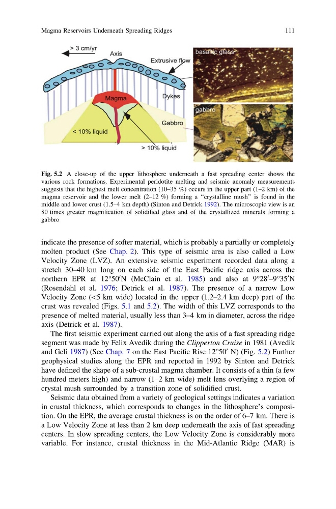
crust was revealed (Figs. 5.1 and 5.2). The width of this LVZ corresponds to the
presence of melted material, usually less than 3–4 km in diameter, across the ridge
axis (Detrick et al. 1987).
The first seismic experiment carried out along the axis of a fast spreading ridge
segment was made by Felix Avedik during the Clipperton Cruise in 1981 (Avedik
and Geli 1987) (See Chap. 7 on the East Pacific Rise 12°50
0 N) (Fig. 5.2) Further
geophysical studies along the EPR and reported in 1992 by Sinton and Detrick
have defined the shape of a sub-crustal magma chamber. It consists of a thin (a few
hundred meters high) and narrow (1–2 km wide) melt lens overlying a region of
crystal mush surrounded by a transition zone of solidified crust.
Seismic data obtained from a variety of geological settings indicates a variation
in crustal thickness, which corresponds to changes in the lithosphere’s composition. On the EPR, the average crustal thickness is on the order of 6–7 km. There is
a Low Velocity Zone at less than 2 km deep underneath the axis of fast spreading
centers. In slow spreading centers, the Low Velocity Zone is considerably more
variable. For instance, crustal thickness in the Mid-Atlantic Ridge (MAR) is
Fig. 5.2 A close-up of the upper lithosphere underneath a fast spreading center shows the
various rock formations. Experimental peridotite melting and seismic anomaly measurements
suggests that the highest melt concentration (10–35 %) occurs in the upper part (1–2 km) of the
magma reservoir and the lower melt (2–12 %) forming a ‘‘crystalline mush’’ is found in the
middle and lower crust (1.5–4 km depth) (Sinton and Detrick 1992). The microscopic view is an
80 times greater magnification of solidified glass and of the crystallized minerals forming a
gabbro
Magma Reservoirs Underneath Spreading Ridges
111
molten product (See Chap. 2). This type of seismic area is also called a Low
Velocity Zone (LVZ). An extensive seismic experiment recorded data along a
stretch 30–40 km long on each side of the East Pacific ridge axis across the
northern EPR at 12°50
0 N (McClain et al. 1985) and also at 9°28
0 –9°35
0 N
(Rosendahl et al. 1976; Detrick et al. 1987). The presence of a narrow Low
Velocity Zone (\5 km wide) located in the upper (1.2–2.4 km deep) part of the
crust was revealed (Figs. 5.1 and 5.2). The width of this LVZ corresponds to the
presence of melted material, usually less than 3–4 km in diameter, across the ridge
axis (Detrick et al. 1987).
The first seismic experiment carried out along the axis of a fast spreading ridge
segment was made by Felix Avedik during the Clipperton Cruise in 1981 (Avedik
and Geli 1987) (See Chap. 7 on the East Pacific Rise 12°50
0 N) (Fig. 5.2) Further
geophysical studies along the EPR and reported in 1992 by Sinton and Detrick
have defined the shape of a sub-crustal magma chamber. It consists of a thin (a few
hundred meters high) and narrow (1–2 km wide) melt lens overlying a region of
crystal mush surrounded by a transition zone of solidified crust.
Seismic data obtained from a variety of geological settings indicates a variation
in crustal thickness, which corresponds to changes in the lithosphere’s composition. On the EPR, the average crustal thickness is on the order of 6–7 km. There is
a Low Velocity Zone at less than 2 km deep underneath the axis of fast spreading
centers. In slow spreading centers, the Low Velocity Zone is considerably more
variable. For instance, crustal thickness in the Mid-Atlantic Ridge (MAR) is
Fig. 5.2 A close-up of the upper lithosphere underneath a fast spreading center shows the
various rock formations. Experimental peridotite melting and seismic anomaly measurements
suggests that the highest melt concentration (10–35 %) occurs in the upper part (1–2 km) of the
magma reservoir and the lower melt (2–12 %) forming a ‘‘crystalline mush’’ is found in the
middle and lower crust (1.5–4 km depth) (Sinton and Detrick 1992). The microscopic view is an
80 times greater magnification of solidified glass and of the crystallized minerals forming a
gabbro
Magma Reservoirs Underneath Spreading Ridges
111