

78
R. Romeiser et al.
(a)
(b)
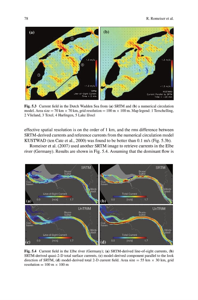
Fig. 5.3 Current field in the Dutch Wadden Sea from (a) SRTM and (b) a numerical circulation
model. Area size = 70 km × 70 km, grid resolution = 100 m × 100 m. Map legend: 1 Terschelling,
2 Vlieland, 3 Texel, 4 Harlingen, 5 Lake IJssel
effective spatial resolution is on the order of 1 km, and the rms difference between
SRTM-derived currents and reference currents from the numerical circulation model
KUSTWAD (ten Cate et al., 2000) was found to be better than 0.1 m/s (Fig. 5.3b).
Romeiser et al. (2007) used another SRTM image to retrieve currents in the Elbe
river (Germany). Results are shown in Fig. 5.4. Assuming that the dominant flow is
)
d
(
)
c
(
(b)
(a)
Fig. 5.4 Current field in the Elbe river (Germany); (a) SRTM-derived line-of-sight currents, (b)
SRTM-derived quasi-2-D total surface currents, (c) model-derived component parallel to the look
direction of SRTM, (d) model-derived total 2-D current field. Area size = 55 km × 30 km, grid
resolution = 100 m × 100 m
R. Romeiser et al.
(a)
(b)
Fig. 5.3 Current field in the Dutch Wadden Sea from (a) SRTM and (b) a numerical circulation
model. Area size = 70 km × 70 km, grid resolution = 100 m × 100 m. Map legend: 1 Terschelling,
2 Vlieland, 3 Texel, 4 Harlingen, 5 Lake IJssel
effective spatial resolution is on the order of 1 km, and the rms difference between
SRTM-derived currents and reference currents from the numerical circulation model
KUSTWAD (ten Cate et al., 2000) was found to be better than 0.1 m/s (Fig. 5.3b).
Romeiser et al. (2007) used another SRTM image to retrieve currents in the Elbe
river (Germany). Results are shown in Fig. 5.4. Assuming that the dominant flow is
)
d
(
)
c
(
(b)
(a)
Fig. 5.4 Current field in the Elbe river (Germany); (a) SRTM-derived line-of-sight currents, (b)
SRTM-derived quasi-2-D total surface currents, (c) model-derived component parallel to the look
direction of SRTM, (d) model-derived total 2-D current field. Area size = 55 km × 30 km, grid
resolution = 100 m × 100 m