

28
C.L. Gentemann et al.
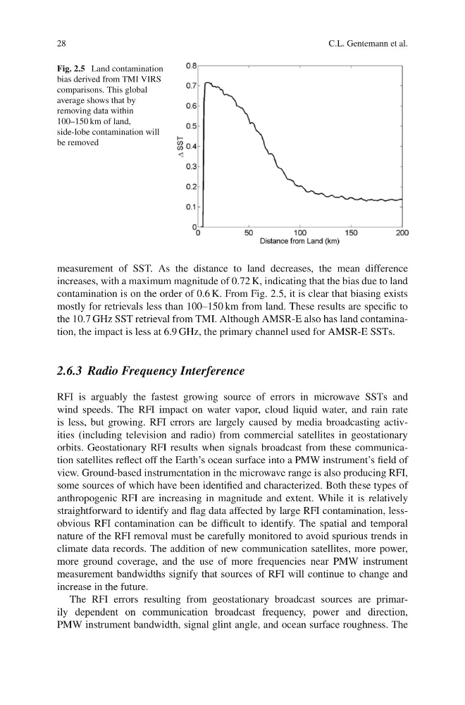
Fig. 2.5 Land contamination
bias derived from TMI VIRS
comparisons. This global
average shows that by
removing data within
100–150 km of land,
side-lobe contamination will
be removed
measurement of SST. As the distance to land decreases, the mean difference
increases, with a maximum magnitude of 0.72 K, indicating that the bias due to land
contamination is on the order of 0.6 K. From Fig. 2.5, it is clear that biasing exists
mostly for retrievals less than 100–150 km from land. These results are specific to
the 10.7 GHz SST retrieval from TMI. Although AMSR-E also has land contamination, the impact is less at 6.9 GHz, the primary channel used for AMSR-E SSTs.
2.6.3 Radio Frequency Interference
RFI is arguably the fastest growing source of errors in microwave SSTs and
wind speeds. The RFI impact on water vapor, cloud liquid water, and rain rate
is less, but growing. RFI errors are largely caused by media broadcasting activities (including television and radio) from commercial satellites in geostationary
orbits. Geostationary RFI results when signals broadcast from these communication satellites reflect off the Earth’s ocean surface into a PMW instrument’s field of
view. Ground-based instrumentation in the microwave range is also producing RFI,
some sources of which have been identified and characterized. Both these types of
anthropogenic RFI are increasing in magnitude and extent. While it is relatively
straightforward to identify and flag data affected by large RFI contamination, lessobvious RFI contamination can be difficult to identify. The spatial and temporal
nature of the RFI removal must be carefully monitored to avoid spurious trends in
climate data records. The addition of new communication satellites, more power,
more ground coverage, and the use of more frequencies near PMW instrument
measurement bandwidths signify that sources of RFI will continue to change and
increase in the future.
The RFI errors resulting from geostationary broadcast sources are primarily dependent on communication broadcast frequency, power and direction,
PMW instrument bandwidth, signal glint angle, and ocean surface roughness. The
C.L. Gentemann et al.
Fig. 2.5 Land contamination
bias derived from TMI VIRS
comparisons. This global
average shows that by
removing data within
100–150 km of land,
side-lobe contamination will
be removed
measurement of SST. As the distance to land decreases, the mean difference
increases, with a maximum magnitude of 0.72 K, indicating that the bias due to land
contamination is on the order of 0.6 K. From Fig. 2.5, it is clear that biasing exists
mostly for retrievals less than 100–150 km from land. These results are specific to
the 10.7 GHz SST retrieval from TMI. Although AMSR-E also has land contamination, the impact is less at 6.9 GHz, the primary channel used for AMSR-E SSTs.
2.6.3 Radio Frequency Interference
RFI is arguably the fastest growing source of errors in microwave SSTs and
wind speeds. The RFI impact on water vapor, cloud liquid water, and rain rate
is less, but growing. RFI errors are largely caused by media broadcasting activities (including television and radio) from commercial satellites in geostationary
orbits. Geostationary RFI results when signals broadcast from these communication satellites reflect off the Earth’s ocean surface into a PMW instrument’s field of
view. Ground-based instrumentation in the microwave range is also producing RFI,
some sources of which have been identified and characterized. Both these types of
anthropogenic RFI are increasing in magnitude and extent. While it is relatively
straightforward to identify and flag data affected by large RFI contamination, lessobvious RFI contamination can be difficult to identify. The spatial and temporal
nature of the RFI removal must be carefully monitored to avoid spurious trends in
climate data records. The addition of new communication satellites, more power,
more ground coverage, and the use of more frequencies near PMW instrument
measurement bandwidths signify that sources of RFI will continue to change and
increase in the future.
The RFI errors resulting from geostationary broadcast sources are primarily dependent on communication broadcast frequency, power and direction,
PMW instrument bandwidth, signal glint angle, and ocean surface roughness. The