

356
S. Sathyendranath and T. Platt
status, such that it becomes important to recognise the dynamic nature of the boundaries of ecosystems (Platt and Sathyendranath, 1999). The concept of ecological
provinces of the ocean, developed initially as an aid to remote sensing of primary production (Longhurst, 2007), has proved extremely useful in this context,
and methods have now emerged that use remote sensing to map the boundaries of
ecological provinces of the ocean at scales that are relevant to the problem at hand
(Devred et al., 2007).
Remote sensing of ocean colour probes the phytoplankton population in the
aquatic environment. But recent studies have shown how the phenology in the phytoplankton dynamics can be linked to processes at higher trophic levels, such that
ocean colour is becoming an important tool in various fisheries applications, ranging from understanding fish recruitment to streamlining fishing operations (IOCCG,
2009). With the advent of methods to study phytoplankton functional types, and
with better understanding of how to link what is observed at the level of phytoplankton to what is happening at the higher trophic levels, ocean-colour is beginning to
contribute to some discussions of marine biodiversity.
Secondary products and applications based on them are likely to continue to
grow in the future. But it is worth considering whether the most interesting and
novel application of remote sensing of ocean colour in the near future might not
be in the arena of high-seas governance and implementation of marine policy and
law. The concept of straddling stocks of commercial fish is well established, and the
implications for setting fisheries policies and settling fishing disputes have been the
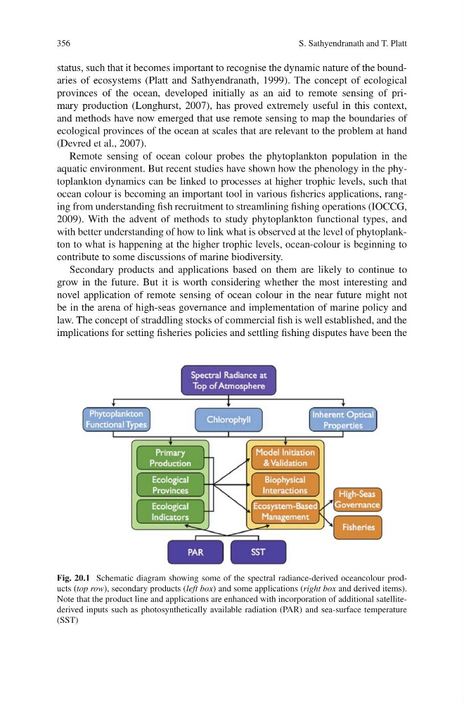
Fig. 20.1 Schematic diagram showing some of the spectral radiance-derived oceancolour products (top row), secondary products (left box) and some applications (right box and derived items).
Note that the product line and applications are enhanced with incorporation of additional satellitederived inputs such as photosynthetically available radiation (PAR) and sea-surface temperature
(SST)
S. Sathyendranath and T. Platt
status, such that it becomes important to recognise the dynamic nature of the boundaries of ecosystems (Platt and Sathyendranath, 1999). The concept of ecological
provinces of the ocean, developed initially as an aid to remote sensing of primary production (Longhurst, 2007), has proved extremely useful in this context,
and methods have now emerged that use remote sensing to map the boundaries of
ecological provinces of the ocean at scales that are relevant to the problem at hand
(Devred et al., 2007).
Remote sensing of ocean colour probes the phytoplankton population in the
aquatic environment. But recent studies have shown how the phenology in the phytoplankton dynamics can be linked to processes at higher trophic levels, such that
ocean colour is becoming an important tool in various fisheries applications, ranging from understanding fish recruitment to streamlining fishing operations (IOCCG,
2009). With the advent of methods to study phytoplankton functional types, and
with better understanding of how to link what is observed at the level of phytoplankton to what is happening at the higher trophic levels, ocean-colour is beginning to
contribute to some discussions of marine biodiversity.
Secondary products and applications based on them are likely to continue to
grow in the future. But it is worth considering whether the most interesting and
novel application of remote sensing of ocean colour in the near future might not
be in the arena of high-seas governance and implementation of marine policy and
law. The concept of straddling stocks of commercial fish is well established, and the
implications for setting fisheries policies and settling fishing disputes have been the
Fig. 20.1 Schematic diagram showing some of the spectral radiance-derived oceancolour products (top row), secondary products (left box) and some applications (right box and derived items).
Note that the product line and applications are enhanced with incorporation of additional satellitederived inputs such as photosynthetically available radiation (PAR) and sea-surface temperature
(SST)