

190
W.H.F. Smith
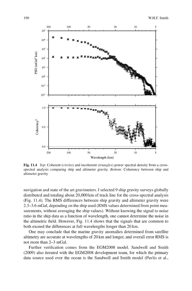
Fig. 11.4 Top: Coherent (circles) and incoherent (triangles) power spectral density from a crossspectral analysis comparing ship and altimeter gravity. Bottom: Coherency between ship and
altimeter gravity
navigation and state of the art gravimeters. I selected 9 ship gravity surveys globally
distributed and totaling about 20,000 km of track line for the cross-spectral analysis
(Fig. 11.4). The RMS differences between ship gravity and altimeter gravity were
2.3–3.6 mGal, depending on the ship used (RMS values determined from point measurements, without averaging the ship values). Without knowing the signal to noise
ratio in the ship data as a function of wavelength, one cannot determine the noise in
the altimetric field. However, Fig. 11.4 shows that the signals that are common to
both exceed the differences at full wavelengths longer than 20 km.
One may conclude that the marine gravity anomalies determined from satellite
altimetry are accurate at wavelengths of 20 km and longer, and overall error RMS is
not more than 2–3 mGal.
Further verification comes from the EGM2008 model. Sandwell and Smith
(2009) also iterated with the EGM2008 development team, for which the primary
data source used over the ocean is the Sandwell and Smith model (Pavlis et al.,
W.H.F. Smith
Fig. 11.4 Top: Coherent (circles) and incoherent (triangles) power spectral density from a crossspectral analysis comparing ship and altimeter gravity. Bottom: Coherency between ship and
altimeter gravity
navigation and state of the art gravimeters. I selected 9 ship gravity surveys globally
distributed and totaling about 20,000 km of track line for the cross-spectral analysis
(Fig. 11.4). The RMS differences between ship gravity and altimeter gravity were
2.3–3.6 mGal, depending on the ship used (RMS values determined from point measurements, without averaging the ship values). Without knowing the signal to noise
ratio in the ship data as a function of wavelength, one cannot determine the noise in
the altimetric field. However, Fig. 11.4 shows that the signals that are common to
both exceed the differences at full wavelengths longer than 20 km.
One may conclude that the marine gravity anomalies determined from satellite
altimetry are accurate at wavelengths of 20 km and longer, and overall error RMS is
not more than 2–3 mGal.
Further verification comes from the EGM2008 model. Sandwell and Smith
(2009) also iterated with the EGM2008 development team, for which the primary
data source used over the ocean is the Sandwell and Smith model (Pavlis et al.,