

166
M.-H. Rio
the altimetric height η a mean profile computed over a given period of time P. Under
the assumption of a stationary geoid, the residual quantity is the sea level anomaly
h = η relative to the time period P. The routine computation and exploitation of
the Sea level anomalies has led to numerous advances in our knowledge of the ocean
mesoscale (Fu and Cazenave, 2001).
In order to reconstruct the full dynamical signal from the SLA, the missing quantity is the Mean Dynamic Topography, i.e., the average over the period P of the sea
level above the geoid. Up to a given spatial scale, governed by the geoid model
accuracy, the Mean Dynamic Topography can be derived by subtracting the geoid
from an altimetric Mean Sea Surface. This is the so-called “direct method”, whose
actual applicability has been greatly improved since the very first altimetric missions, as will be described in Section 10.2 of the present chapter. However, in order
to retrieve the shortest spatial scales of the Mean Dynamic Topography, and therefore compute the ocean absolute dynamic topography with sufficient accuracy, a
number of methods have been developed which are further described in Section
10.3. In Section 10.4, we will make a (non exhaustive) review of scientific advances
that have been made possible by the use of these Mean Dynamic Topography estimates and in Section 10.5 we will finally discuss the potential and limits of the use
of future GOCE data.
10.2 Twenty Years of Geoid Improvements and Its Impact
for MDT Determination
Since the very first global geoid model computation, based on the analysis of satellite’s orbit perturbation, important technological and conceptual steps have been
made for computing the Earth gravity field from space leading to the launch of gravity dedicated space missions as CHAMP (2000), GRACE (2002) and more recently
GOCE (2009).
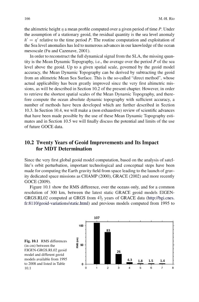
Figure 10.1 show the RMS difference, over the oceans only, and for a common
resolution of 300 km, between the latest static GRACE geoid models EIGENGRGS.RL02 computed at GRGS from 4
1
/ 2 years of GRACE data (http://bgi.cnes.
fr:8110/geoid-variations/static.html) and previous models computed from 1995 to
Fig. 10.1 RMS differences
(in cm) between the
EIGEN-GRGS.RL02 geoid
model and different geoid
models available from 1995
to 2008 and listed in Table
10.1
M.-H. Rio
the altimetric height η a mean profile computed over a given period of time P. Under
the assumption of a stationary geoid, the residual quantity is the sea level anomaly
h = η relative to the time period P. The routine computation and exploitation of
the Sea level anomalies has led to numerous advances in our knowledge of the ocean
mesoscale (Fu and Cazenave, 2001).
In order to reconstruct the full dynamical signal from the SLA, the missing quantity is the Mean Dynamic Topography, i.e., the average over the period P of the sea
level above the geoid. Up to a given spatial scale, governed by the geoid model
accuracy, the Mean Dynamic Topography can be derived by subtracting the geoid
from an altimetric Mean Sea Surface. This is the so-called “direct method”, whose
actual applicability has been greatly improved since the very first altimetric missions, as will be described in Section 10.2 of the present chapter. However, in order
to retrieve the shortest spatial scales of the Mean Dynamic Topography, and therefore compute the ocean absolute dynamic topography with sufficient accuracy, a
number of methods have been developed which are further described in Section
10.3. In Section 10.4, we will make a (non exhaustive) review of scientific advances
that have been made possible by the use of these Mean Dynamic Topography estimates and in Section 10.5 we will finally discuss the potential and limits of the use
of future GOCE data.
10.2 Twenty Years of Geoid Improvements and Its Impact
for MDT Determination
Since the very first global geoid model computation, based on the analysis of satellite’s orbit perturbation, important technological and conceptual steps have been
made for computing the Earth gravity field from space leading to the launch of gravity dedicated space missions as CHAMP (2000), GRACE (2002) and more recently
GOCE (2009).
Figure 10.1 show the RMS difference, over the oceans only, and for a common
resolution of 300 km, between the latest static GRACE geoid models EIGENGRGS.RL02 computed at GRGS from 4
1
/ 2 years of GRACE data (http://bgi.cnes.
fr:8110/geoid-variations/static.html) and previous models computed from 1995 to
Fig. 10.1 RMS differences
(in cm) between the
EIGEN-GRGS.RL02 geoid
model and different geoid
models available from 1995
to 2008 and listed in Table
10.1