

8 Perspectives on Oil Spill Detection Using Synthetic Aperture Radar
137
the final product quality. A number of these issues yield an increase of the false positives, others introduce “non-exploitable” areas within the image leading to potential
false negatives in the detection process.
Some SAR image particularities, well known to SAR engineers but perhaps less
so to the downstream service providers, can cause serious problems with the service
product, such as azimuth and range ambiguities giving rise to false ship detections.
In such cases, the SAR image may be in accordance with specifications, but the
impact of some image artifacts on the final product is still problematic, e.g. when
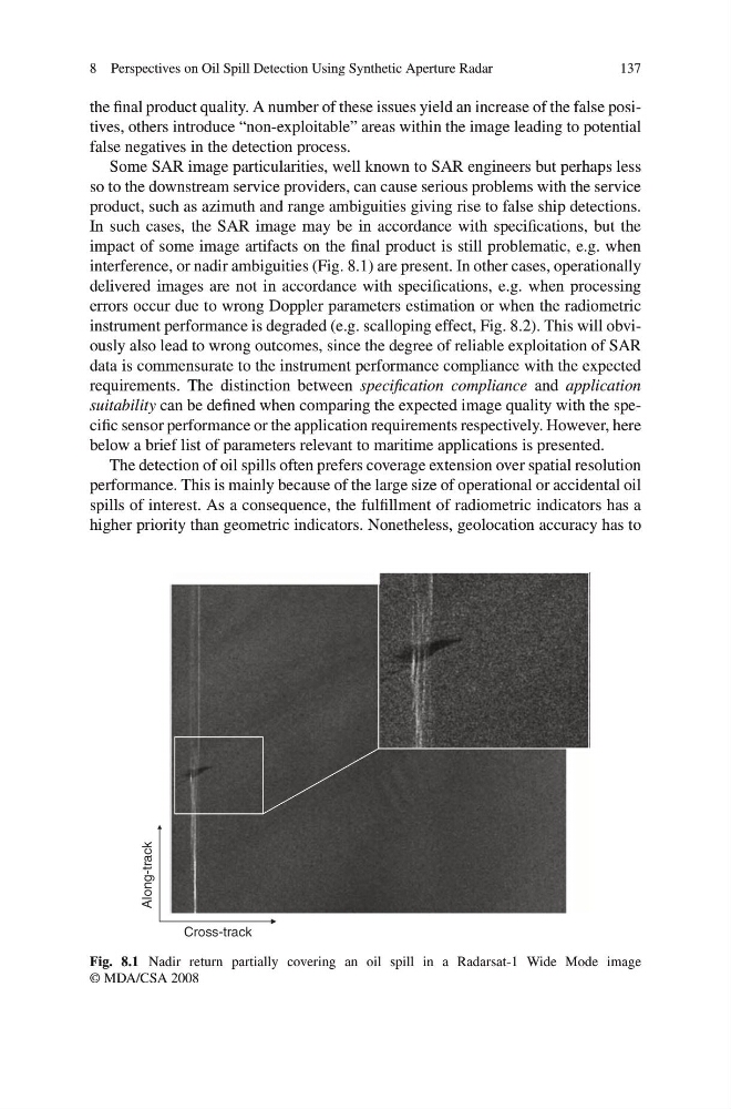
interference, or nadir ambiguities (Fig. 8.1) are present. In other cases, operationally
delivered images are not in accordance with specifications, e.g. when processing
errors occur due to wrong Doppler parameters estimation or when the radiometric
instrument performance is degraded (e.g. scalloping effect, Fig. 8.2). This will obviously also lead to wrong outcomes, since the degree of reliable exploitation of SAR
data is commensurate to the instrument performance compliance with the expected
requirements. The distinction between specification compliance and application
suitability can be defined when comparing the expected image quality with the specific sensor performance or the application requirements respectively. However, here
below a brief list of parameters relevant to maritime applications is presented.
The detection of oil spills often prefers coverage extension over spatial resolution
performance. This is mainly because of the large size of operational or accidental oil
spills of interest. As a consequence, the fulfillment of radiometric indicators has a
higher priority than geometric indicators. Nonetheless, geolocation accuracy has to
Cross-track
Along-track
Fig. 8.1 Nadir return partially covering an oil spill in a Radarsat-1 Wide Mode image
© MDA/CSA 2008
137
the final product quality. A number of these issues yield an increase of the false positives, others introduce “non-exploitable” areas within the image leading to potential
false negatives in the detection process.
Some SAR image particularities, well known to SAR engineers but perhaps less
so to the downstream service providers, can cause serious problems with the service
product, such as azimuth and range ambiguities giving rise to false ship detections.
In such cases, the SAR image may be in accordance with specifications, but the
impact of some image artifacts on the final product is still problematic, e.g. when
interference, or nadir ambiguities (Fig. 8.1) are present. In other cases, operationally
delivered images are not in accordance with specifications, e.g. when processing
errors occur due to wrong Doppler parameters estimation or when the radiometric
instrument performance is degraded (e.g. scalloping effect, Fig. 8.2). This will obviously also lead to wrong outcomes, since the degree of reliable exploitation of SAR
data is commensurate to the instrument performance compliance with the expected
requirements. The distinction between specification compliance and application
suitability can be defined when comparing the expected image quality with the specific sensor performance or the application requirements respectively. However, here
below a brief list of parameters relevant to maritime applications is presented.
The detection of oil spills often prefers coverage extension over spatial resolution
performance. This is mainly because of the large size of operational or accidental oil
spills of interest. As a consequence, the fulfillment of radiometric indicators has a
higher priority than geometric indicators. Nonetheless, geolocation accuracy has to
Cross-track
Along-track
Fig. 8.1 Nadir return partially covering an oil spill in a Radarsat-1 Wide Mode image
© MDA/CSA 2008