

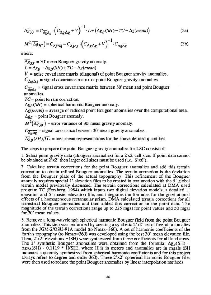
.1g 30 , = C"AgAg . ( C .1g.1g + V) -1. L + (.1g B (SH) - TC + .1g(mean))
M 2 (.1g 30 ,) = C!J.gAg - C"AgIlg· (C.1g.1g + V )-1. C AgAg
where:
.1g 30 , = 30' mean Bouguer gravity anomaly.
L = .1g B - .1g B (SH) + TC - .1g(mean)
V = noise covariance matrix (diagonal) of point Bouguer gravity anomalies.
C .1g.1g = signal covariance matrix of point Bouguer gravity anomalies.
C"Ag1lg = signal cross covariance matrix between 30' mean and point Bouguer
anomalies.
TC = point terrain correction .
.1g B (SH) = spherical harmonic Bouguer anomaly .
(3a)
(3b)
.1g(mean) = average of reduced point Bouguer anomalies over the computational area .
.1g B = point Bouguer anomaly.
M 2 ( .1g 30') = error variance of 30' mean gravity anomaly.
C"Ag Ilg = signal covariance between 30' mean gravity anomalies .
.1g B (SH),TC = area-mean representations for the above defined quantities.
The steps to prepare the point Bouguer gravity anomalies for LSC consist of:
1. Select point gravity data (Bouguer anomalies) for a 2'x2' cell size. If point data cannot
be obtained at 2'x2' then larger cell sizes must be used (i.e., 6'x6').
2. Calculate terrain corrections for the point Bouguer anomalies and add this terrain
correction to obtain refined Bouguer anomalies. The terrain correction is the deviation
from the Bouguer plate of the actual topography. This refinement of the Bouguer
anomaly requires special l' elevation files to be created in conjunction with the 5' global
terrain model previously discussed. The terrain corrections calculated at DMA used
program TC (Forsberg, 1984) which inputs two digital elevation models, a detailed l'
elevation and 5' master elevation file, and integrates the formulas for the gravitational
effects of a homogeneous rectangular prism. DMA calculated terrain corrections for all
terrestrial Bouguer anomalies and then added this correction to the point data. The
magnitude of the terrain corrections range up to 225 mgal for point values and 50 mgal
for 30' mean values.
3. Remove a long-wavelength spherical harmonic Bouguer field from the point Bouguer
anomalies. This step was performed by creating a synthetic 2'x2' set of free-air anomalies
from the JGM-2/0SU-91A model (to Nmax=360). A set of harmonic coefficients of the
Earth's topography (to Nmax=360) was developed using the best 30' mean elevation file.
Then, 2 'x2' elevations H(SH) were synthesized from these coefficients for all land areas.
The 2' synthetic Bouguer anomalies were obtained from the formula: .1gB(SH) =
.1gpA(SH) - 0.1119 * H(SH), where H is in meters and anomalies are in mgals (SH
indicates a quantity synthesized from spherical harmonic coefficients and for this project
always refers to degree and order 360). These 2'x2' spherical harmonic Bouguer files
were then used to reduce the point Bouguer anomalies by linear interpolation methods.
86
M 2 (.1g 30 ,) = C!J.gAg - C"AgIlg· (C.1g.1g + V )-1. C AgAg
where:
.1g 30 , = 30' mean Bouguer gravity anomaly.
L = .1g B - .1g B (SH) + TC - .1g(mean)
V = noise covariance matrix (diagonal) of point Bouguer gravity anomalies.
C .1g.1g = signal covariance matrix of point Bouguer gravity anomalies.
C"Ag1lg = signal cross covariance matrix between 30' mean and point Bouguer
anomalies.
TC = point terrain correction .
.1g B (SH) = spherical harmonic Bouguer anomaly .
(3a)
(3b)
.1g(mean) = average of reduced point Bouguer anomalies over the computational area .
.1g B = point Bouguer anomaly.
M 2 ( .1g 30') = error variance of 30' mean gravity anomaly.
C"Ag Ilg = signal covariance between 30' mean gravity anomalies .
.1g B (SH),TC = area-mean representations for the above defined quantities.
The steps to prepare the point Bouguer gravity anomalies for LSC consist of:
1. Select point gravity data (Bouguer anomalies) for a 2'x2' cell size. If point data cannot
be obtained at 2'x2' then larger cell sizes must be used (i.e., 6'x6').
2. Calculate terrain corrections for the point Bouguer anomalies and add this terrain
correction to obtain refined Bouguer anomalies. The terrain correction is the deviation
from the Bouguer plate of the actual topography. This refinement of the Bouguer
anomaly requires special l' elevation files to be created in conjunction with the 5' global
terrain model previously discussed. The terrain corrections calculated at DMA used
program TC (Forsberg, 1984) which inputs two digital elevation models, a detailed l'
elevation and 5' master elevation file, and integrates the formulas for the gravitational
effects of a homogeneous rectangular prism. DMA calculated terrain corrections for all
terrestrial Bouguer anomalies and then added this correction to the point data. The
magnitude of the terrain corrections range up to 225 mgal for point values and 50 mgal
for 30' mean values.
3. Remove a long-wavelength spherical harmonic Bouguer field from the point Bouguer
anomalies. This step was performed by creating a synthetic 2'x2' set of free-air anomalies
from the JGM-2/0SU-91A model (to Nmax=360). A set of harmonic coefficients of the
Earth's topography (to Nmax=360) was developed using the best 30' mean elevation file.
Then, 2 'x2' elevations H(SH) were synthesized from these coefficients for all land areas.
The 2' synthetic Bouguer anomalies were obtained from the formula: .1gB(SH) =
.1gpA(SH) - 0.1119 * H(SH), where H is in meters and anomalies are in mgals (SH
indicates a quantity synthesized from spherical harmonic coefficients and for this project
always refers to degree and order 360). These 2'x2' spherical harmonic Bouguer files
were then used to reduce the point Bouguer anomalies by linear interpolation methods.
86