

GFZ95A GRAVITY FIELD MODEL
The model, obtained by the procedure and the input data sets, described in the previous
section is named GFZ95A. For quality assessment different tests are performed. All those
tests represent only a small spot of the overall quality, which in general is very difficult
to estimate. For comparisons, the Ohio State University OSU9lA model, which is also
complete to degree and order 360 is taken (Rapp R.H. et al (1991).
For testing the long wavelength features, a good independent test is the quality of orbital
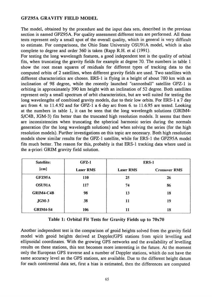
fits, when truncating the gravity fields for example at degree 70. The numbers in table 1
show the root mean squares of residuals for different types of tracking data to the
computed orbits of 2 satellites, when different gravity fields are used. Two satellites with
different characteristics are chosen. ERS-1 is flying in a height of about 780 km with an
inclination of 98 degree, while the recently launched "cannonball" satellite GFZ-1 is
orbiting in approximately 390 km height with an inclination of 52 degree. Both satellites
represent only a small spectrum of orbit characteristics, but are well suited for testing the
long wavelengths of combined gravity models, due to their low orbits. For ERS-1 a 7 day
arc from 4. to 11.4.92 and for GFZ-1 a 6 day arc from 6. to 11.6.95 are tested. Looking
at the numbers in table 1, it can be seen that the long wavelength solutions (GRIM4S/C4B, JGM-3) fits better than the truncated high resolution models. It seems that there
are inconsistencies when truncating the spherical harmonic series during the normals
generation (for the long wavelength solutions) and when solving the series (for the high
resolution models). Further investigations on this topic are necessary. Both high resolution
models show similar results for the GFZ-1 satellite, while for ERS-1 the GFZ95A model
fits much better. The reason for this, probably is that ERS-I tracking data where used in
the a-priori GRIM gravity field solution.
Satellite:
GFZ-l
ERS-l
[em]
Laser RMS
Laser RMS
Crossover RMS
GFZ95A
110
25
26
OSU91A
117
74
86
GRIM4-C4B
98
13
18
JGM-3
38
11
19
GRIM4-S4
106
11
18
Table 1: Orbital Fit Tests for Gravity Fields up to 70x70
Another independent test is the comparison of geoid heights solved from the gravity field
model with geoid heights derived at Doppler/GPS stations from spirit levelling and
ellipsoidal coordinates. With the growing GPS networks and the availability of levelling
results on these stations, this test becomes more interesting in the future. At the moment
only the European GPS traverse and a number of Doppler stations, which do not have the
same accuracy level as the GPS stations, are available. Due to the different height datum
for each continental data set, first a bias is estimated, then the differences are computed
65
The model, obtained by the procedure and the input data sets, described in the previous
section is named GFZ95A. For quality assessment different tests are performed. All those
tests represent only a small spot of the overall quality, which in general is very difficult
to estimate. For comparisons, the Ohio State University OSU9lA model, which is also
complete to degree and order 360 is taken (Rapp R.H. et al (1991).
For testing the long wavelength features, a good independent test is the quality of orbital
fits, when truncating the gravity fields for example at degree 70. The numbers in table 1
show the root mean squares of residuals for different types of tracking data to the
computed orbits of 2 satellites, when different gravity fields are used. Two satellites with
different characteristics are chosen. ERS-1 is flying in a height of about 780 km with an
inclination of 98 degree, while the recently launched "cannonball" satellite GFZ-1 is
orbiting in approximately 390 km height with an inclination of 52 degree. Both satellites
represent only a small spectrum of orbit characteristics, but are well suited for testing the
long wavelengths of combined gravity models, due to their low orbits. For ERS-1 a 7 day
arc from 4. to 11.4.92 and for GFZ-1 a 6 day arc from 6. to 11.6.95 are tested. Looking
at the numbers in table 1, it can be seen that the long wavelength solutions (GRIM4S/C4B, JGM-3) fits better than the truncated high resolution models. It seems that there
are inconsistencies when truncating the spherical harmonic series during the normals
generation (for the long wavelength solutions) and when solving the series (for the high
resolution models). Further investigations on this topic are necessary. Both high resolution
models show similar results for the GFZ-1 satellite, while for ERS-1 the GFZ95A model
fits much better. The reason for this, probably is that ERS-I tracking data where used in
the a-priori GRIM gravity field solution.
Satellite:
GFZ-l
ERS-l
[em]
Laser RMS
Laser RMS
Crossover RMS
GFZ95A
110
25
26
OSU91A
117
74
86
GRIM4-C4B
98
13
18
JGM-3
38
11
19
GRIM4-S4
106
11
18
Table 1: Orbital Fit Tests for Gravity Fields up to 70x70
Another independent test is the comparison of geoid heights solved from the gravity field
model with geoid heights derived at Doppler/GPS stations from spirit levelling and
ellipsoidal coordinates. With the growing GPS networks and the availability of levelling
results on these stations, this test becomes more interesting in the future. At the moment
only the European GPS traverse and a number of Doppler stations, which do not have the
same accuracy level as the GPS stations, are available. Due to the different height datum
for each continental data set, first a bias is estimated, then the differences are computed
65