

Investigation of Methods for Global Gravity Field Recovery
from the Dense ERS-l Geodetic Mission Altimetry
o Ba Andersen and P Knudsen (Kort- og Matrikelstyrelsen, Copenhagen NY,
Denmark. E-mail: oa@kms.min.dk and pk@krns.min.dk)
C C Tscheming (Geofysisk Dept., University of Copenhagen, Copenhagen 0,
Denmark, E-mail: cct@osiris.gfy.ku.dk)
Abstract. A number of different methods for gravity field prediction from altimetry
were investig:ated in an area of the Greenland-Iceland-Norweg:ian sea. The
~
~
investigation was carried out in an area with a relatively small oceanographic signal.
The methods investigated were gravity field prediction using inverse Stokes method
implemented using FFT and least squares collocation (LSC). The LSC procedure was
investigated using different numbers of altimeter data and different procedures. These
were gravity field prediction from direct altimetric observations and gravity field
prediction using altimeter-derived along-track deflections of the vertical.
For the derivation of the global marine gravity field we decided to use inverse
Stokes method implemented using FFT as it gives virtually the same result as would
have been obtained using LSC directly. However we are missing the associated errorestimates which are obtained using LSC. These may, however, be estimated from the
error-estimates obtained in the test area, by scaling the error-estimate using the ration
between the local gravity variation and the value in the test area.
Introduction.
Since the completion of the
geodetic phase of the ERS-l satellite a
global data set of high quality with a
very homogeneous distribution has
been available. In areas where good
ship-gravity is available, we then have
the possibility of testing gravity field
prediction procedures as a function of
the method and the data density used
in the calculations. Such tests have
earlier been carried out using satellite
altimetry by, e.g. Rapp (1985, 1986).
In Zhang & Blais (1995) results using
Fast Fourier Transformation methods
(FFT) and least-squares collocation
(LSC) (Moritz, 1980) are compared,
and it is concluded that the two
68.0
66.0
64.0
62.0
60.0
·)0.0
-5.0
01>
5.0
10.0
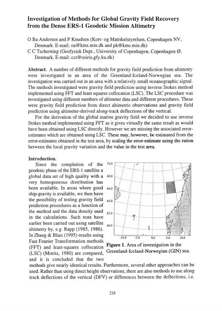
Figure 1. Area of investigation in the
Greenland-Iceland-Norwegian (GIN) sea.
methods give nearly identical results. Furthermore, several other approaches can be
used. Rather than using direct height observations, there are also methods to use along
track deflections of the vertical (DFV) or differences between the deflections, i.e.
218
from the Dense ERS-l Geodetic Mission Altimetry
o Ba Andersen and P Knudsen (Kort- og Matrikelstyrelsen, Copenhagen NY,
Denmark. E-mail: oa@kms.min.dk and pk@krns.min.dk)
C C Tscheming (Geofysisk Dept., University of Copenhagen, Copenhagen 0,
Denmark, E-mail: cct@osiris.gfy.ku.dk)
Abstract. A number of different methods for gravity field prediction from altimetry
were investig:ated in an area of the Greenland-Iceland-Norweg:ian sea. The
~
~
investigation was carried out in an area with a relatively small oceanographic signal.
The methods investigated were gravity field prediction using inverse Stokes method
implemented using FFT and least squares collocation (LSC). The LSC procedure was
investigated using different numbers of altimeter data and different procedures. These
were gravity field prediction from direct altimetric observations and gravity field
prediction using altimeter-derived along-track deflections of the vertical.
For the derivation of the global marine gravity field we decided to use inverse
Stokes method implemented using FFT as it gives virtually the same result as would
have been obtained using LSC directly. However we are missing the associated errorestimates which are obtained using LSC. These may, however, be estimated from the
error-estimates obtained in the test area, by scaling the error-estimate using the ration
between the local gravity variation and the value in the test area.
Introduction.
Since the completion of the
geodetic phase of the ERS-l satellite a
global data set of high quality with a
very homogeneous distribution has
been available. In areas where good
ship-gravity is available, we then have
the possibility of testing gravity field
prediction procedures as a function of
the method and the data density used
in the calculations. Such tests have
earlier been carried out using satellite
altimetry by, e.g. Rapp (1985, 1986).
In Zhang & Blais (1995) results using
Fast Fourier Transformation methods
(FFT) and least-squares collocation
(LSC) (Moritz, 1980) are compared,
and it is concluded that the two
68.0
66.0
64.0
62.0
60.0
·)0.0
-5.0
01>
5.0
10.0
Figure 1. Area of investigation in the
Greenland-Iceland-Norwegian (GIN) sea.
methods give nearly identical results. Furthermore, several other approaches can be
used. Rather than using direct height observations, there are also methods to use along
track deflections of the vertical (DFV) or differences between the deflections, i.e.
218