

40
3 The Oceanographic Context
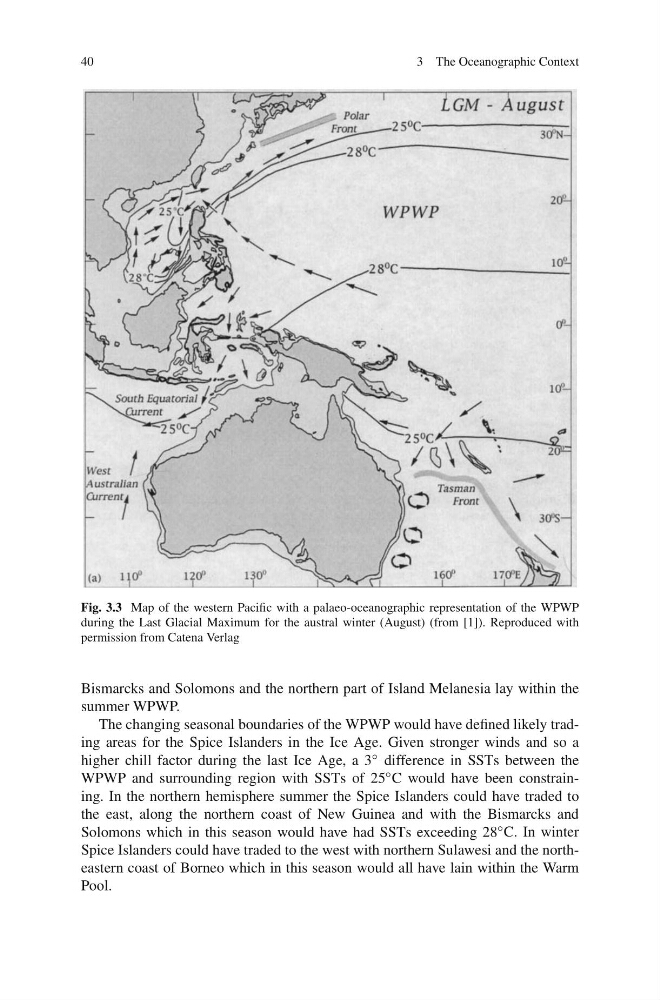
Fig. 3.3 Map of the western Pacific with a palaeo-oceanographic representation of the WPWP
during the Last Glacial Maximum for the austral winter (August) (from [1]). Reproduced with
permission from Catena Verlag
Bismarcks and Solomons and the northern part of Island Melanesia lay within the
summer WPWP.
The changing seasonal boundaries of the WPWP would have defined likely trading areas for the Spice Islanders in the Ice Age. Given stronger winds and so a
higher chill factor during the last Ice Age, a 3 ◦ difference in SSTs between the
WPWP and surrounding region with SSTs of 25 ◦ C would have been constraining. In the northern hemisphere summer the Spice Islanders could have traded to
the east, along the northern coast of New Guinea and with the Bismarcks and
Solomons which in this season would have had SSTs exceeding 28 ◦ C. In winter
Spice Islanders could have traded to the west with northern Sulawesi and the northeastern coast of Borneo which in this season would all have lain within the Warm
Pool.
3 The Oceanographic Context
Fig. 3.3 Map of the western Pacific with a palaeo-oceanographic representation of the WPWP
during the Last Glacial Maximum for the austral winter (August) (from [1]). Reproduced with
permission from Catena Verlag
Bismarcks and Solomons and the northern part of Island Melanesia lay within the
summer WPWP.
The changing seasonal boundaries of the WPWP would have defined likely trading areas for the Spice Islanders in the Ice Age. Given stronger winds and so a
higher chill factor during the last Ice Age, a 3 ◦ difference in SSTs between the
WPWP and surrounding region with SSTs of 25 ◦ C would have been constraining. In the northern hemisphere summer the Spice Islanders could have traded to
the east, along the northern coast of New Guinea and with the Bismarcks and
Solomons which in this season would have had SSTs exceeding 28 ◦ C. In winter
Spice Islanders could have traded to the west with northern Sulawesi and the northeastern coast of Borneo which in this season would all have lain within the Warm
Pool.