

38
3 The Oceanographic Context
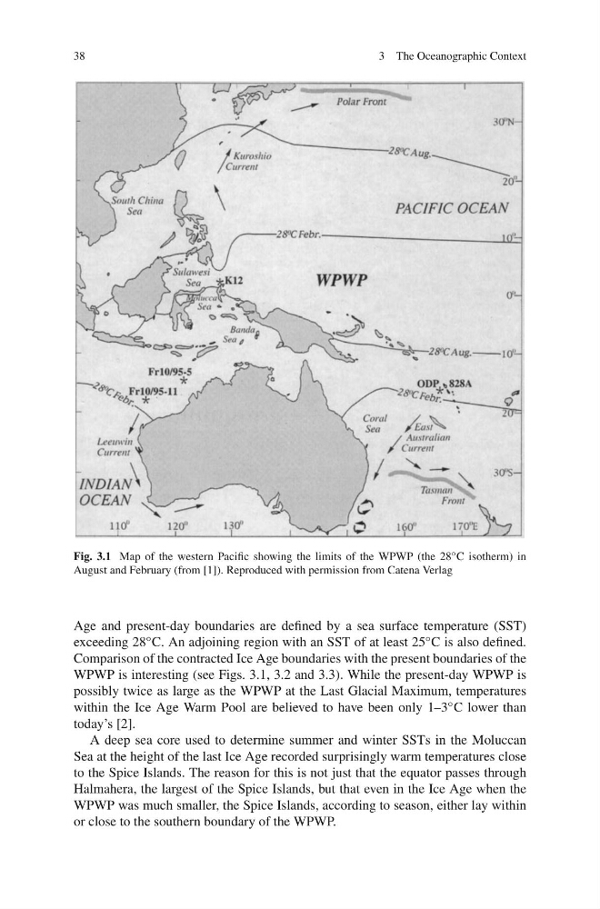
Fig. 3.1 Map of the western Pacific showing the limits of the WPWP (the 28 ◦ C isotherm) in
August and February (from [1]). Reproduced with permission from Catena Verlag
Age and present-day boundaries are defined by a sea surface temperature (SST)
exceeding 28 ◦ C. An adjoining region with an SST of at least 25 ◦ C is also defined.
Comparison of the contracted Ice Age boundaries with the present boundaries of the
WPWP is interesting (see Figs. 3.1, 3.2 and 3.3). While the present-day WPWP is
possibly twice as large as the WPWP at the Last Glacial Maximum, temperatures
within the Ice Age Warm Pool are believed to have been only 1–3 ◦ C lower than
today’s [2].
A deep sea core used to determine summer and winter SSTs in the Moluccan
Sea at the height of the last Ice Age recorded surprisingly warm temperatures close
to the Spice Islands. The reason for this is not just that the equator passes through
Halmahera, the largest of the Spice Islands, but that even in the Ice Age when the
WPWP was much smaller, the Spice Islands, according to season, either lay within
or close to the southern boundary of the WPWP.
3 The Oceanographic Context
Fig. 3.1 Map of the western Pacific showing the limits of the WPWP (the 28 ◦ C isotherm) in
August and February (from [1]). Reproduced with permission from Catena Verlag
Age and present-day boundaries are defined by a sea surface temperature (SST)
exceeding 28 ◦ C. An adjoining region with an SST of at least 25 ◦ C is also defined.
Comparison of the contracted Ice Age boundaries with the present boundaries of the
WPWP is interesting (see Figs. 3.1, 3.2 and 3.3). While the present-day WPWP is
possibly twice as large as the WPWP at the Last Glacial Maximum, temperatures
within the Ice Age Warm Pool are believed to have been only 1–3 ◦ C lower than
today’s [2].
A deep sea core used to determine summer and winter SSTs in the Moluccan
Sea at the height of the last Ice Age recorded surprisingly warm temperatures close
to the Spice Islands. The reason for this is not just that the equator passes through
Halmahera, the largest of the Spice Islands, but that even in the Ice Age when the
WPWP was much smaller, the Spice Islands, according to season, either lay within
or close to the southern boundary of the WPWP.