

662
Land-Ocean Systems in the Siberian Arctic: Dynamics and History
50 m
ID
( CO
. . .
80m
1.2 km - - - - - - - - -... ~
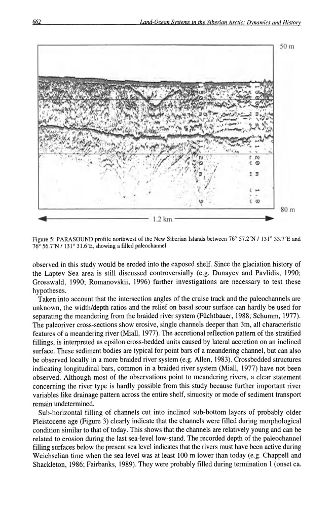
Figure 5: PARASOUND profile northwest of the New Siberian Islands between 76° 57 .2'N I 131 ° 33.7'E and
76° 56.7'N 1131 ° 31.6 'E, showing a filled paleochannel
observed in this study would be eroded into the exposed shelf. Since the glaciation history of
the Laptev Sea area is still discussed controversially (e.g . Dunayev and Pavlidis, 1990;
Grosswald, 1990; Romanovskii, 1996) further investigations are necessary to test these
hypotheses.
Taken into account that the intersection angles of the cruise track and the paleochannels are
unknown, the width/depth ratios and the relief on basal scour surface can hardly be used for
separating the meandering from the braided river system (Ftichtbauer, 1988; Schumm, 1977).
The paleoriver cross-sections show erosive, single channels deeper than 3m, all characteristic
features of a meandering river (Miall, 1977). The accretional reflection pattern of the stratified
fillings, is interpreted as epsilon cross-bedded units caused by lateral accretion on an inclined
surface. These sediment bodies are typical for point bars of a meandering channel, but can also
be observed locally in a more braided river system (e.g. Allen, 1983). Crossbedded structures
indicating longitudinal bars, common in a braided river system (Miall, 1977) have not been
observed. Although most of the observations point to meandering rivers, a clear statement
concerning the river type is hardly possible from this study because further important river
variables like drainage pattern across the entire shelf, sinuosity or mode of sediment transport
remain undetermined.
Sub-horizontal filling of channels cut into inclined sub-bottom layers of probably older
Pleistocene age (Figure 3) clearly indicate that the channels were filled during morphological
condition similar to that of today. This shows that the channels are relatively young and can be
related to erosion during the last sea-level low-stand. The recorded depth of the paleochannel
filling surfaces below the present sea level indicates that the rivers must have been active during
Weichselian time when the sea level was at least 100 m lower than today (e.g. Chappell and
Shackleton, 1986; Fairbanks, 1989). They were probably filled during termination 1 (onset ca.
Land-Ocean Systems in the Siberian Arctic: Dynamics and History
50 m
ID
( CO
. . .
80m
1.2 km - - - - - - - - -... ~
Figure 5: PARASOUND profile northwest of the New Siberian Islands between 76° 57 .2'N I 131 ° 33.7'E and
76° 56.7'N 1131 ° 31.6 'E, showing a filled paleochannel
observed in this study would be eroded into the exposed shelf. Since the glaciation history of
the Laptev Sea area is still discussed controversially (e.g . Dunayev and Pavlidis, 1990;
Grosswald, 1990; Romanovskii, 1996) further investigations are necessary to test these
hypotheses.
Taken into account that the intersection angles of the cruise track and the paleochannels are
unknown, the width/depth ratios and the relief on basal scour surface can hardly be used for
separating the meandering from the braided river system (Ftichtbauer, 1988; Schumm, 1977).
The paleoriver cross-sections show erosive, single channels deeper than 3m, all characteristic
features of a meandering river (Miall, 1977). The accretional reflection pattern of the stratified
fillings, is interpreted as epsilon cross-bedded units caused by lateral accretion on an inclined
surface. These sediment bodies are typical for point bars of a meandering channel, but can also
be observed locally in a more braided river system (e.g. Allen, 1983). Crossbedded structures
indicating longitudinal bars, common in a braided river system (Miall, 1977) have not been
observed. Although most of the observations point to meandering rivers, a clear statement
concerning the river type is hardly possible from this study because further important river
variables like drainage pattern across the entire shelf, sinuosity or mode of sediment transport
remain undetermined.
Sub-horizontal filling of channels cut into inclined sub-bottom layers of probably older
Pleistocene age (Figure 3) clearly indicate that the channels were filled during morphological
condition similar to that of today. This shows that the channels are relatively young and can be
related to erosion during the last sea-level low-stand. The recorded depth of the paleochannel
filling surfaces below the present sea level indicates that the rivers must have been active during
Weichselian time when the sea level was at least 100 m lower than today (e.g. Chappell and
Shackleton, 1986; Fairbanks, 1989). They were probably filled during termination 1 (onset ca.