

660
Land-Ocean Systems in the Siberian Arctic: Dynamics and History
50 m
80m
... ~------------ 2.8 km - - - - - - - - --1 ...
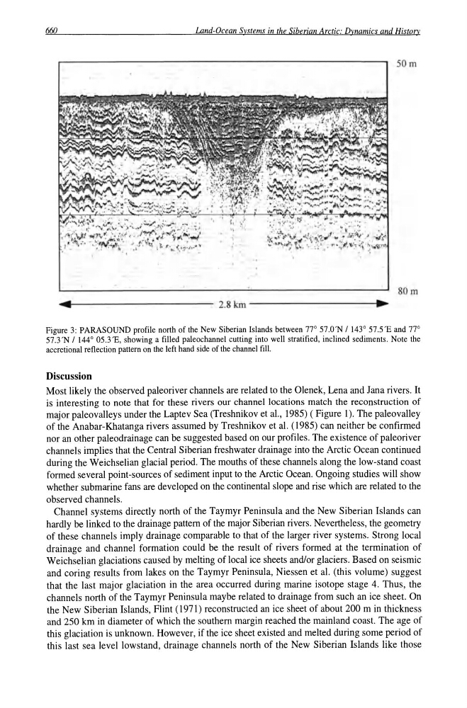
Figure 3: PARASOUND profile north of the New Siberian Islands between 77° 57.0'N / 143° 57.5'E and 77°
57.3 'N / 144 0 05.3'E, showing a filled paleochannel cutting into well stratified, inclined sediments. Note the
accretional reflection pattern on the left hand side of the channel fill.
Discussion
Most likely the observed paleoriver channels are related to the Olenek, Lena and Jana rivers. It
is interesting to note that for these rivers our channel locations match the reconstruction of
major paleovalleys under the Laptev Sea (Treshnikov et aI., 1985) ( Figure 1). The paleovalley
of the Anabar-Khatanga rivers assumed by Treshnikov et al. (1985) can neither be confirmed
nor an other paleodrainage can be suggested based on our profiles. The existence of paleoriver
channels implies that the Central Siberian freshwater drainage into the Arctic Ocean continued
during the Weichselian glacial period. The mouths of these channels along the low-stand coast
formed several point-sources of sediment input to the Arctic Ocean. Ongoing studies will show
whether submarine fans are developed on the continental slope and rise which are related to the
observed channels.
Channel systems directly north of the Taymyr Peninsula and the New Siberian Islands can
hardly be linked to the drainage pattern of the major Siberian rivers. Nevertheless, the geometry
of these channels imply drainage comparable to that of the larger river systems. Strong local
drainage and channel formation could be the result of rivers formed at the termination of
Weichselian glaciations caused by melting of local ice sheets andlor glaciers. Based on seismic
and coring results from lakes on the Taymyr Peninsula, Niessen et al. (this volume) suggest
that the last major glaciation in the area occurred during marine isotope stage 4. Thus, the
channels north of the Taymyr Peninsula maybe related to drainage from such an ice sheet. On
the New Siberian Islands, Flint (1971) reconstructed an ice sheet of about 200 m in thickness
and 250 km in diameter of which the southern margin reached the mainland coast. The age of
this glaciation is unknown. However, if the ice sheet existed and melted during some period of
this last sea level lowstand, drainage channels north of the New Siberian Islands like those
Land-Ocean Systems in the Siberian Arctic: Dynamics and History
50 m
80m
... ~------------ 2.8 km - - - - - - - - --1 ...
Figure 3: PARASOUND profile north of the New Siberian Islands between 77° 57.0'N / 143° 57.5'E and 77°
57.3 'N / 144 0 05.3'E, showing a filled paleochannel cutting into well stratified, inclined sediments. Note the
accretional reflection pattern on the left hand side of the channel fill.
Discussion
Most likely the observed paleoriver channels are related to the Olenek, Lena and Jana rivers. It
is interesting to note that for these rivers our channel locations match the reconstruction of
major paleovalleys under the Laptev Sea (Treshnikov et aI., 1985) ( Figure 1). The paleovalley
of the Anabar-Khatanga rivers assumed by Treshnikov et al. (1985) can neither be confirmed
nor an other paleodrainage can be suggested based on our profiles. The existence of paleoriver
channels implies that the Central Siberian freshwater drainage into the Arctic Ocean continued
during the Weichselian glacial period. The mouths of these channels along the low-stand coast
formed several point-sources of sediment input to the Arctic Ocean. Ongoing studies will show
whether submarine fans are developed on the continental slope and rise which are related to the
observed channels.
Channel systems directly north of the Taymyr Peninsula and the New Siberian Islands can
hardly be linked to the drainage pattern of the major Siberian rivers. Nevertheless, the geometry
of these channels imply drainage comparable to that of the larger river systems. Strong local
drainage and channel formation could be the result of rivers formed at the termination of
Weichselian glaciations caused by melting of local ice sheets andlor glaciers. Based on seismic
and coring results from lakes on the Taymyr Peninsula, Niessen et al. (this volume) suggest
that the last major glaciation in the area occurred during marine isotope stage 4. Thus, the
channels north of the Taymyr Peninsula maybe related to drainage from such an ice sheet. On
the New Siberian Islands, Flint (1971) reconstructed an ice sheet of about 200 m in thickness
and 250 km in diameter of which the southern margin reached the mainland coast. The age of
this glaciation is unknown. However, if the ice sheet existed and melted during some period of
this last sea level lowstand, drainage channels north of the New Siberian Islands like those