

Niessen et al: High-Resolution Seismic Stratigraphy of Lake Sediments on the Taymyr Peninsula
453
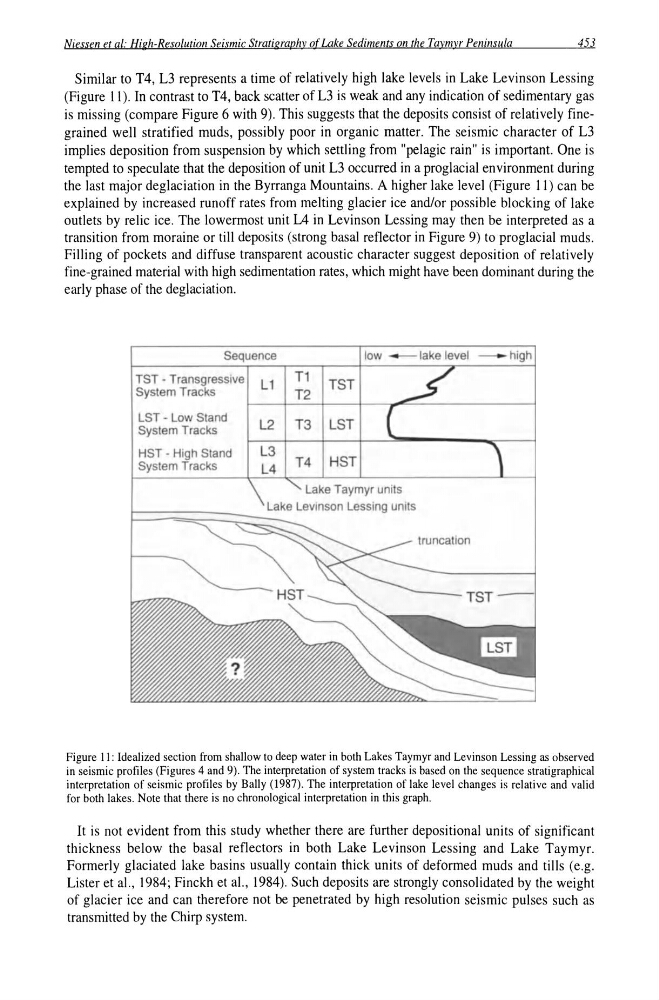
Similar to T4, L3 represents a time of relatively high lake levels in Lake Levinson Lessing
(Figure II). In contrast to T4, back scatter of L3 is weak and any indication of sedimentary gas
is missing (compare Figure 6 with 9). This suggests that the deposits consist of relatively finegrained well stratified muds, possibly poor in organic matter. The seismic character of L3
implies deposition from suspension by which settling from "pelagic rain" is important. One is
tempted to speculate that the deposition of unit L3 occurred in a proglacial environment during
the last major deglaciation in the Byrranga Mountains. A higher lake level (Figure 11) can be
explained by increased runoff rates from melting glacier ice and/or possible blocking of lake
outlets by relic ice. The lowermost unit L4 in Levinson Lessing may then be interpreted as a
transition from moraine or till deposits (strong basal reflector in Figure 9) to proglacial muds.
Filling of pockets and diffuse transparent acoustic character suggest deposition of relatively
fine-grained material with high sedimentation rates, which might have been dominant during the
early phase of the deglaciation.
LST - Low Stand
System Tracks
HST - High Stand
System Tracks
L2
L3
T3 LST
T4 HST
Lake Taymyr units
TST
Figure 11: Idealized section from shallow to deep water in both Lakes Taymyr and Levinson Lessing as observed
in seismic profiles (Figures 4 and 9). The interpretation of system tracks is based on the sequence stratigraphical
interpretation of seismic profiles by Bally (1987). The interpretation of lake level changes is relative and valid
for both lakes. Note that there is no chronological interpretation in this graph.
It is not evident from this study whether there are further depositional units of significant
thickness below the basal reflectors in both Lake Levinson Lessing and Lake Taymyr.
Formerly glaciated lake basins usually contain thick units of deformed muds and tills (e.g.
Lister et aI. , 1984; Finckh et aI., 1984). Such deposits are strongly consolidated by the weight
of glacier ice and can therefore not be penetrated by high resolution seismic pulses such as
transmitted by the Chirp system.
453
Similar to T4, L3 represents a time of relatively high lake levels in Lake Levinson Lessing
(Figure II). In contrast to T4, back scatter of L3 is weak and any indication of sedimentary gas
is missing (compare Figure 6 with 9). This suggests that the deposits consist of relatively finegrained well stratified muds, possibly poor in organic matter. The seismic character of L3
implies deposition from suspension by which settling from "pelagic rain" is important. One is
tempted to speculate that the deposition of unit L3 occurred in a proglacial environment during
the last major deglaciation in the Byrranga Mountains. A higher lake level (Figure 11) can be
explained by increased runoff rates from melting glacier ice and/or possible blocking of lake
outlets by relic ice. The lowermost unit L4 in Levinson Lessing may then be interpreted as a
transition from moraine or till deposits (strong basal reflector in Figure 9) to proglacial muds.
Filling of pockets and diffuse transparent acoustic character suggest deposition of relatively
fine-grained material with high sedimentation rates, which might have been dominant during the
early phase of the deglaciation.
LST - Low Stand
System Tracks
HST - High Stand
System Tracks
L2
L3
T3 LST
T4 HST
Lake Taymyr units
TST
Figure 11: Idealized section from shallow to deep water in both Lakes Taymyr and Levinson Lessing as observed
in seismic profiles (Figures 4 and 9). The interpretation of system tracks is based on the sequence stratigraphical
interpretation of seismic profiles by Bally (1987). The interpretation of lake level changes is relative and valid
for both lakes. Note that there is no chronological interpretation in this graph.
It is not evident from this study whether there are further depositional units of significant
thickness below the basal reflectors in both Lake Levinson Lessing and Lake Taymyr.
Formerly glaciated lake basins usually contain thick units of deformed muds and tills (e.g.
Lister et aI. , 1984; Finckh et aI., 1984). Such deposits are strongly consolidated by the weight
of glacier ice and can therefore not be penetrated by high resolution seismic pulses such as
transmitted by the Chirp system.