

Niessen et al: High-Resolution Seismic Stratigranhy of'Lake Sediments on the Taymyr Peninsula
439
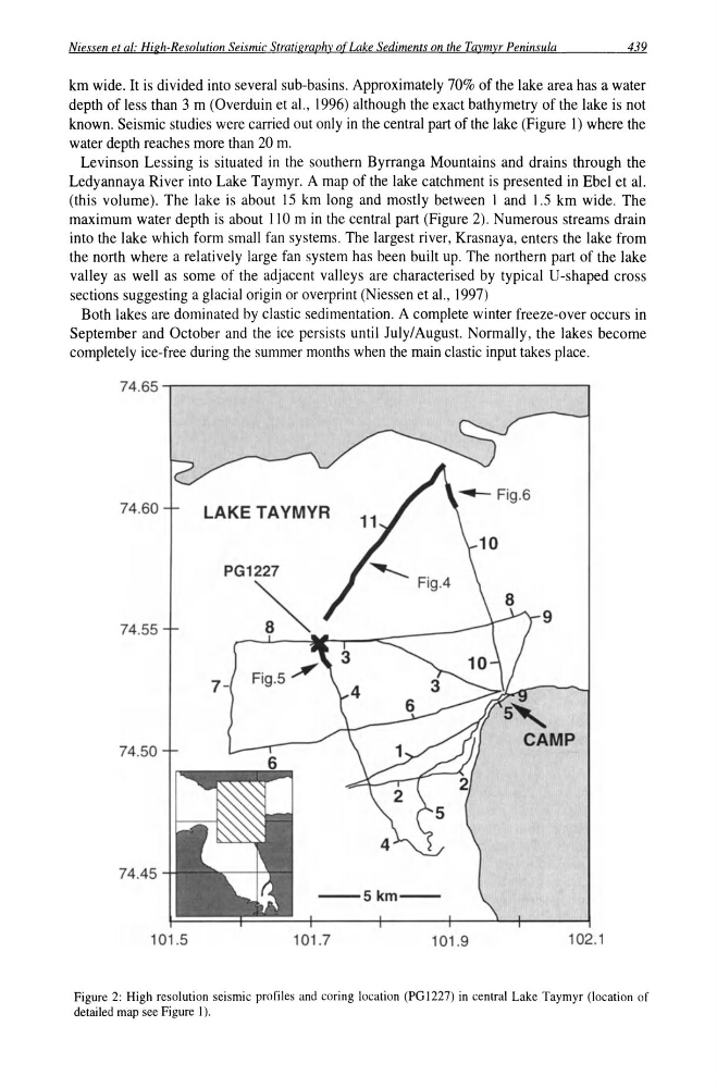
km wide. It is divided into several sub-basins. Approximately 70% of the lake area has a water
depth of less than 3 m (Overduin et a!., 1996) although the exact bathymetry of the lake is not
known. Seismic studies were carried out only in the central part of the lake (Figure 1) where the
water depth reaches more than 20 m.
Levinson Lessing is situated in the southern Byrranga Mountains and drains through the
Ledyannaya River into Lake Taymyr. A map of the lake catchment is presented in Ebel et al.
(this volume). The lake is about 15 km long and mostly between 1 and 1.5 km wide. The
maximum water depth is about 110m in the central part (Figure 2). Numerous streams drain
into the lake which form small fan systems. The largest river, Krasnaya, enters the lake from
the north where a relatively large fan system has been built up. The northern part of the lake
valley as well as some of the adjacent valleys are characterised by typical U-shaped cross
sections suggesting a glacial origin or overprint (Niessen et a!., 1997)
Both lakes are dominated by clastic sedimentation. A complete winter freeze-over occurs in
September and October and the ice persists until July/August. Normally, the lakes become
completely ice-free during the summer months when the main clastic input takes place.
7 4 . 6 5 , . - - - - - - - - - - - - - - - - - - - - - - ,
74.60
LAKE TAYMYR
74.55
74.50
74.45
- 5 k m -
101.5
101.7
101.9
102.1
Figure 2: High resolution seismic profiles and coring location (PG 1227) in central Lake Taymyr (location of
detailed map see Figure I).
439
km wide. It is divided into several sub-basins. Approximately 70% of the lake area has a water
depth of less than 3 m (Overduin et a!., 1996) although the exact bathymetry of the lake is not
known. Seismic studies were carried out only in the central part of the lake (Figure 1) where the
water depth reaches more than 20 m.
Levinson Lessing is situated in the southern Byrranga Mountains and drains through the
Ledyannaya River into Lake Taymyr. A map of the lake catchment is presented in Ebel et al.
(this volume). The lake is about 15 km long and mostly between 1 and 1.5 km wide. The
maximum water depth is about 110m in the central part (Figure 2). Numerous streams drain
into the lake which form small fan systems. The largest river, Krasnaya, enters the lake from
the north where a relatively large fan system has been built up. The northern part of the lake
valley as well as some of the adjacent valleys are characterised by typical U-shaped cross
sections suggesting a glacial origin or overprint (Niessen et a!., 1997)
Both lakes are dominated by clastic sedimentation. A complete winter freeze-over occurs in
September and October and the ice persists until July/August. Normally, the lakes become
completely ice-free during the summer months when the main clastic input takes place.
7 4 . 6 5 , . - - - - - - - - - - - - - - - - - - - - - - ,
74.60
LAKE TAYMYR
74.55
74.50
74.45
- 5 k m -
101.5
101.7
101.9
102.1
Figure 2: High resolution seismic profiles and coring location (PG 1227) in central Lake Taymyr (location of
detailed map see Figure I).