

426
Land-Ocean Systems in the Siberian Arctic: Dynamics and History
characteristics during spring and summer are shown. The lower pH values in the upper 10
meters observed in the beginning of July are caused by acidic meltwater from snow seeping
through the ice cover and from melting of the lake ice itself at the ice/water-interface. Oxygen
supersaturation occurs in the still stagnant waterbody when phytoplancton production, initiated
by increasing light availability due to higher solar radiation and the improving transparency of
the exposed ice cover, starts at the end of June. The minor inverse thermal gradient observed in
spring time is due to the cooling effect of the ice cover and ceases just after melting of the lake
ice is complete in August.
-10
Last Glacial Maximum
~ mitWrun variant
~ rrJ8)OtJUn V81fanr
o mountain g/acfB1S
~
,
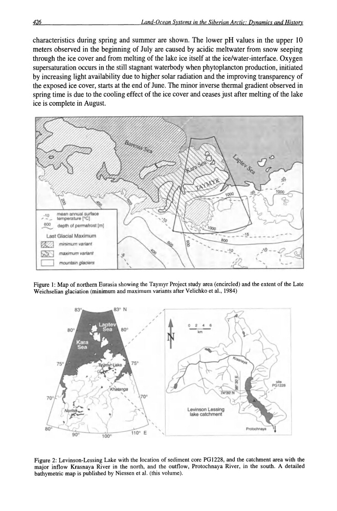
Figure I: Map of northern Eurasia showing the Taymyr Project study area (encircled) and the extent of the Late
Weichselian glaciation (minimum and maximum variants after Velichko et ai., 1984)
, ,
o 2 • e
kin
Levinson Lesslng
lake catchment
Figure 2: Levinson-Lessing Lake with the location of sediment core PG1228, and the catchment area with the
major inflow Krasnaya River in the north, and the outflow, Protochnaya River, in the south. A detailed
bathymetric map is published by Niessen et al. (this volume).
Land-Ocean Systems in the Siberian Arctic: Dynamics and History
characteristics during spring and summer are shown. The lower pH values in the upper 10
meters observed in the beginning of July are caused by acidic meltwater from snow seeping
through the ice cover and from melting of the lake ice itself at the ice/water-interface. Oxygen
supersaturation occurs in the still stagnant waterbody when phytoplancton production, initiated
by increasing light availability due to higher solar radiation and the improving transparency of
the exposed ice cover, starts at the end of June. The minor inverse thermal gradient observed in
spring time is due to the cooling effect of the ice cover and ceases just after melting of the lake
ice is complete in August.
-10
Last Glacial Maximum
~ mitWrun variant
~ rrJ8)OtJUn V81fanr
o mountain g/acfB1S
~
,
Figure I: Map of northern Eurasia showing the Taymyr Project study area (encircled) and the extent of the Late
Weichselian glaciation (minimum and maximum variants after Velichko et ai., 1984)
, ,
o 2 • e
kin
Levinson Lesslng
lake catchment
Figure 2: Levinson-Lessing Lake with the location of sediment core PG1228, and the catchment area with the
major inflow Krasnaya River in the north, and the outflow, Protochnaya River, in the south. A detailed
bathymetric map is published by Niessen et al. (this volume).