

408
Land-Ocean SYstems in the Siberian Arctic: Dynamics and History
results supply new information concerning the temporal and spatial variations in the position
and extent of vegetation zones since Middle Weichselian time. The influence of climate
variability on these variations is studied by comparing the palynological results with ice core
data from Severnaya Zemlya.
High-arctic
: Tundra :
," ,"." .".','::.:: :' A~cli~' ::::
:: Tundra :::
::::::::::::::::::
90'
100'
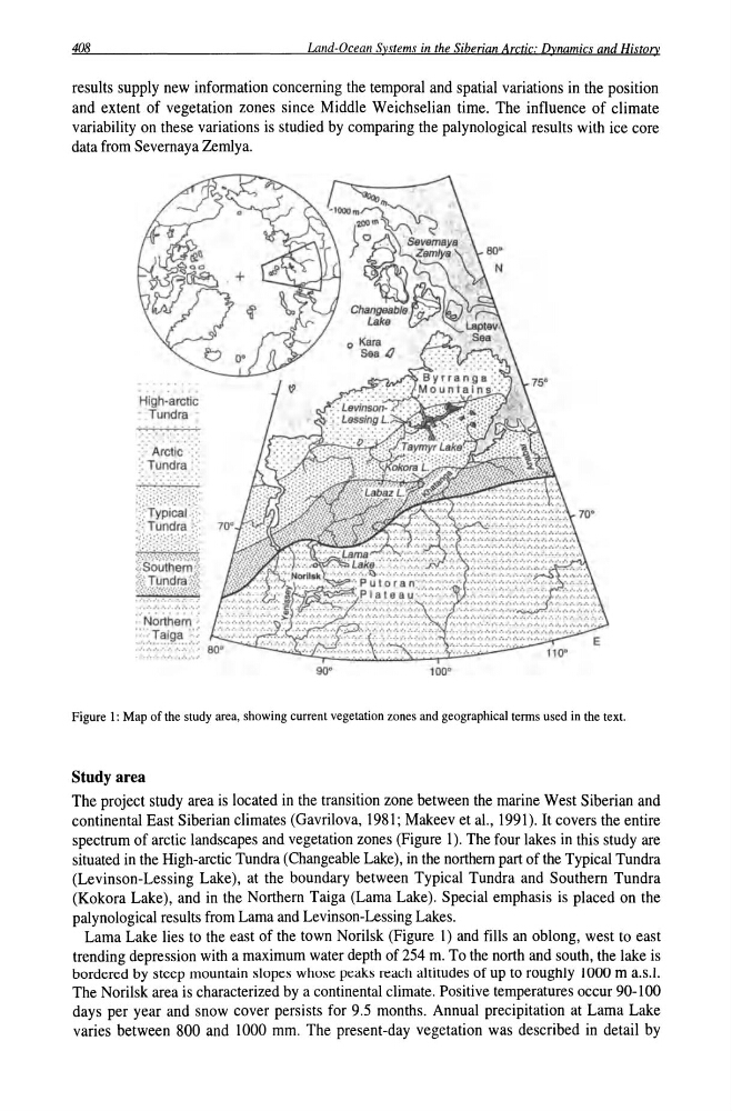
Figure 1: Map of the study area, showing current vegetation zones and geographical terms used in the text.
Study area
The project study area is located in the transition zone between the marine West Siberian and
continental East Siberian climates (Gavrilova, 1981; Makeev et ai., 1991). It covers the entire
spectrum of arctic landscapes and vegetation zones (Figure 1). The four lakes in this study are
situated in the High-arctic Tundra (Changeable Lake), in the northern part of the Typical Tundra
(Levinson-Lessing Lake), at the boundary between Typical Tundra and Southern Tundra
(Kokora Lake), and in the Northern Taiga (Lama Lake). Special emphasis is placed on the
palynological results from Lama and Levinson-Lessing Lakes.
Lama Lake lies to the east of the town Norilsk (Figure 1) and fills an oblong, west to east
trending depression with a maximum water depth of 254 m. To the north and south, the lake is
bordered by steep mountain slopes whose peaks reach altitudes of up to roughly 1000 m a.s.!.
The Norilsk area is characterized by a continental climate. Positive temperatures occur 90-100
days per year and snow cover persists for 9.5 months. Annual precipitation at Lama Lake
varies between 800 and 1000 mm. The present-day vegetation was described in detail by
Land-Ocean SYstems in the Siberian Arctic: Dynamics and History
results supply new information concerning the temporal and spatial variations in the position
and extent of vegetation zones since Middle Weichselian time. The influence of climate
variability on these variations is studied by comparing the palynological results with ice core
data from Severnaya Zemlya.
High-arctic
: Tundra :
," ,"." .".','::.:: :' A~cli~' ::::
:: Tundra :::
::::::::::::::::::
90'
100'
Figure 1: Map of the study area, showing current vegetation zones and geographical terms used in the text.
Study area
The project study area is located in the transition zone between the marine West Siberian and
continental East Siberian climates (Gavrilova, 1981; Makeev et ai., 1991). It covers the entire
spectrum of arctic landscapes and vegetation zones (Figure 1). The four lakes in this study are
situated in the High-arctic Tundra (Changeable Lake), in the northern part of the Typical Tundra
(Levinson-Lessing Lake), at the boundary between Typical Tundra and Southern Tundra
(Kokora Lake), and in the Northern Taiga (Lama Lake). Special emphasis is placed on the
palynological results from Lama and Levinson-Lessing Lakes.
Lama Lake lies to the east of the town Norilsk (Figure 1) and fills an oblong, west to east
trending depression with a maximum water depth of 254 m. To the north and south, the lake is
bordered by steep mountain slopes whose peaks reach altitudes of up to roughly 1000 m a.s.!.
The Norilsk area is characterized by a continental climate. Positive temperatures occur 90-100
days per year and snow cover persists for 9.5 months. Annual precipitation at Lama Lake
varies between 800 and 1000 mm. The present-day vegetation was described in detail by