

252
Land-Ocean Systems in the Siberian Arctic: Dynamics and History
To advance our understanding of the processes connected to the river breakup and peakstream flow in the Siberian Arctic the multidisciplinary Transdrift IV expedition started in
spring of 1996 (Kassens, 1996). Primary investigation areas were the Bykovskaya distributary
and the Laptev Sea off the major river outlets ( i.e. Bykovskaya, Trofimovskaya mouths).
75r---------------~------------------------------~
74
73
72
120
125
as
c
QI
....I
73·
72
Buor-Khaya( \
bay
J ~
~j
130
135 E
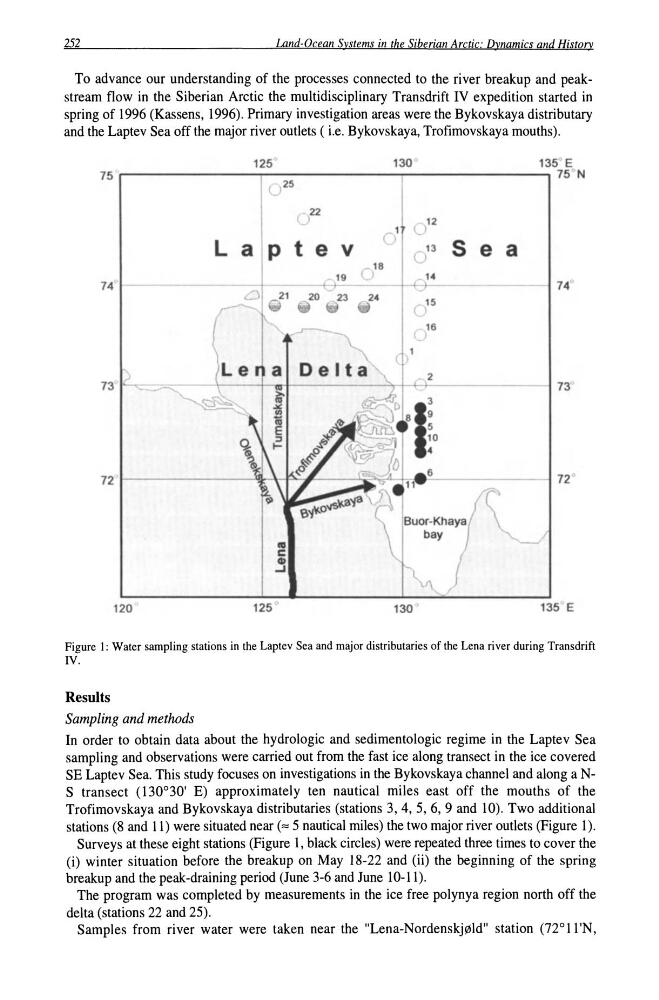
Figure 1: Water sampling stations in the Laptev Sea and major distributaries of the Lena river during Transdrift
IV.
Results
Sampling and methods
In order to obtain data about the hydrologic and sedimentologic regime in the Laptev Sea
sampling and observations were carried out from the fast ice along transect in the ice covered
SE Laptev Sea. This study focuses on investigations in the Bykovskaya channel and along a NS transect (130°30' E) approximately ten nautical miles east off the mouths of the
Trofimovskaya and Bykovskaya distributaries (stations 3, 4, 5, 6, 9 and 10). Two additional
stations (8 and 11) were situated near (z 5 nautical miles) the two major river outlets (Figure 1).
Surveys at these eight stations (Figure 1, black circles) were repeated three times to cover the
(i) winter situation before the breakup on May 18-22 and (ii) the beginning of the spring
breakup and the peak-draining period (June 3-6 and June 10-11).
The program was completed by measurements in the ice free polynya region north off the
delta (stations 22 and 25).
Samples from river water were taken near the "Lena-Nordenskjpld" station (72°11 'N,
Land-Ocean Systems in the Siberian Arctic: Dynamics and History
To advance our understanding of the processes connected to the river breakup and peakstream flow in the Siberian Arctic the multidisciplinary Transdrift IV expedition started in
spring of 1996 (Kassens, 1996). Primary investigation areas were the Bykovskaya distributary
and the Laptev Sea off the major river outlets ( i.e. Bykovskaya, Trofimovskaya mouths).
75r---------------~------------------------------~
74
73
72
120
125
as
c
QI
....I
73·
72
Buor-Khaya( \
bay
J ~
~j
130
135 E
Figure 1: Water sampling stations in the Laptev Sea and major distributaries of the Lena river during Transdrift
IV.
Results
Sampling and methods
In order to obtain data about the hydrologic and sedimentologic regime in the Laptev Sea
sampling and observations were carried out from the fast ice along transect in the ice covered
SE Laptev Sea. This study focuses on investigations in the Bykovskaya channel and along a NS transect (130°30' E) approximately ten nautical miles east off the mouths of the
Trofimovskaya and Bykovskaya distributaries (stations 3, 4, 5, 6, 9 and 10). Two additional
stations (8 and 11) were situated near (z 5 nautical miles) the two major river outlets (Figure 1).
Surveys at these eight stations (Figure 1, black circles) were repeated three times to cover the
(i) winter situation before the breakup on May 18-22 and (ii) the beginning of the spring
breakup and the peak-draining period (June 3-6 and June 10-11).
The program was completed by measurements in the ice free polynya region north off the
delta (stations 22 and 25).
Samples from river water were taken near the "Lena-Nordenskjpld" station (72°11 'N,