

proportion of dikes reach the seafloor and erupt to the
north resulting in greater magmatic overprinting. This is
consistent with a break in the axial magma lens and
magma compositions that become more mafic to the north
of this discontinuity. Thus, it appears that the AST provides a visible record of the frequency of eruptions, which
tend to infill a consistently growing graben.
Summary
The axial summit trough is a common feature along the
ridge crest of fast- and intermediate-spreading rate ridges
and is present along slower-spreading but magma-rich
ridges. The trough forms from deformation due to shallowly intruded dikes, with deformation accumulating over
many years, but the graben dimensions are modified by
narrow AST
no AST
wide AST
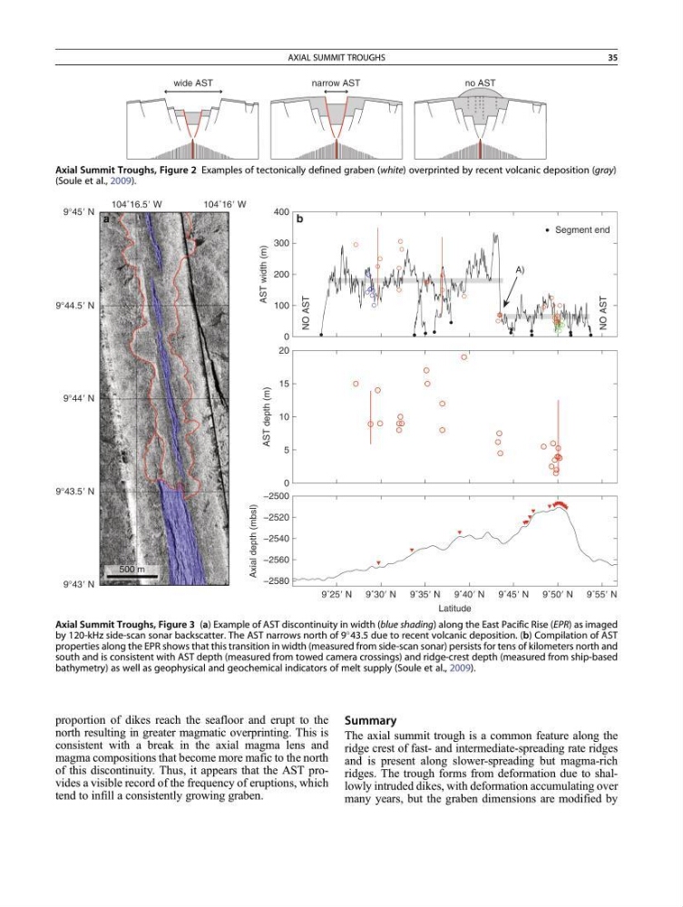
Axial Summit Troughs, Figure 2 Examples of tectonically defined graben (white) overprinted by recent volcanic deposition (gray)
(Soule et al., 2009).
0
100
200
300
400
AST width (m)
NO AST
NO AST
0
5
10
15
20
AST depth (m)
Segment end
9˚25Ј N
9˚30Ј N
9˚35Ј N
9˚40Ј N
9˚45Ј N
9˚50Ј N
9˚55Ј N
−2580
−2560
−2540
−2520
−2500
Axial depth (mbsl)
Latitude
104˚16Ј W
104˚16.5Ј W
9°45Ј N
9°44Ј N
9°43Ј N
9°43.5Ј N
9°44.5Ј N
500 m
A)
a
b
Axial Summit Troughs, Figure 3 (a) Example of AST discontinuity in width (blue shading) along the East Pacific Rise (EPR) as imaged
by 120-kHz side-scan sonar backscatter. The AST narrows north of 9
43.5 due to recent volcanic deposition. (b) Compilation of AST
properties along the EPR shows that this transition in width (measured from side-scan sonar) persists for tens of kilometers north and
south and is consistent with AST depth (measured from towed camera crossings) and ridge-crest depth (measured from ship-based
bathymetry) as well as geophysical and geochemical indicators of melt supply (Soule et al., 2009).
AXIAL SUMMIT TROUGHS
35
north resulting in greater magmatic overprinting. This is
consistent with a break in the axial magma lens and
magma compositions that become more mafic to the north
of this discontinuity. Thus, it appears that the AST provides a visible record of the frequency of eruptions, which
tend to infill a consistently growing graben.
Summary
The axial summit trough is a common feature along the
ridge crest of fast- and intermediate-spreading rate ridges
and is present along slower-spreading but magma-rich
ridges. The trough forms from deformation due to shallowly intruded dikes, with deformation accumulating over
many years, but the graben dimensions are modified by
narrow AST
no AST
wide AST
Axial Summit Troughs, Figure 2 Examples of tectonically defined graben (white) overprinted by recent volcanic deposition (gray)
(Soule et al., 2009).
0
100
200
300
400
AST width (m)
NO AST
NO AST
0
5
10
15
20
AST depth (m)
Segment end
9˚25Ј N
9˚30Ј N
9˚35Ј N
9˚40Ј N
9˚45Ј N
9˚50Ј N
9˚55Ј N
−2580
−2560
−2540
−2520
−2500
Axial depth (mbsl)
Latitude
104˚16Ј W
104˚16.5Ј W
9°45Ј N
9°44Ј N
9°43Ј N
9°43.5Ј N
9°44.5Ј N
500 m
A)
a
b
Axial Summit Troughs, Figure 3 (a) Example of AST discontinuity in width (blue shading) along the East Pacific Rise (EPR) as imaged
by 120-kHz side-scan sonar backscatter. The AST narrows north of 9
43.5 due to recent volcanic deposition. (b) Compilation of AST
properties along the EPR shows that this transition in width (measured from side-scan sonar) persists for tens of kilometers north and
south and is consistent with AST depth (measured from towed camera crossings) and ridge-crest depth (measured from ship-based
bathymetry) as well as geophysical and geochemical indicators of melt supply (Soule et al., 2009).
AXIAL SUMMIT TROUGHS
35