

Development of the axial summit trough
The AST is a volcanically modified tectonic graben. The
graben forms in response to deformation above magmatic
dikes originating at the axial magma lens located 1–3 km
beneath the ridge crest (Chadwick and Embley, 1998;
Fornari et al., 1998). Models of dike intrusion into a
homogeneous elastic medium with physical properties
similar to oceanic crust produce horizontal stresses at the
seafloor, which reach their maximum at distances from
the dike centerline of ~1.5 times the depth to the dike tip
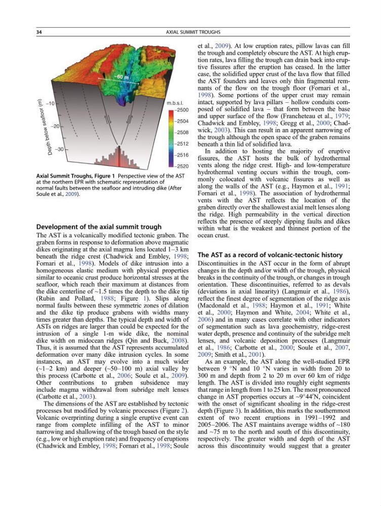
(Rubin and Pollard, 1988; Figure 1). Slips along
normal faults between these symmetric zones of dilation
and the dike tip produce grabens with widths many
times greater than depths. The typical depth and width of
ASTs on ridges are larger than could be expected for the
intrusion of a single 1-m wide dike, the nominal
dike width on midocean ridges (Qin and Buck, 2008).
Thus, it is assumed that the AST represents accumulated
deformation over many dike intrusion cycles. In some
instances, an AST may evolve into a much wider
(~1–2 km) and deeper (~50–100 m) axial valley by
this process (Carbotte et al., 2006; Soule et al., 2009).
Other contributions to graben subsidence may
include magma withdrawal from subridge melt lenses
(Carbotte et al., 2003).
The dimensions of the AST are established by tectonic
processes but modified by volcanic processes (Figure 2).
Volcanic overprinting during a single eruptive event can
range from complete infilling of the AST to minor
narrowing and shallowing of the trough based on the style
(e.g., low or high eruption rate) and frequency of eruptions
(Chadwick and Embley, 1998; Fornari et al., 1998; Soule
et al., 2009). At low eruption rates, pillow lavas can fill
the trough and completely obscure the AST. At high eruption rates, lava filling the trough can drain back into eruptive fissures after the eruption has ceased. In the latter
case, the solidified upper crust of the lava flow that filled
the AST founders and leaves only thin fragmental remnants of the flow on the trough floor (Fornari et al.,
1998). Some portions of the upper crust may remain
intact, supported by lava pillars – hollow conduits composed of solidified lava – that form between the base
and upper surface of the flow (Francheteau et al., 1979;
Chadwick and Embley, 1998; Gregg et al., 2000; Chadwick, 2003). This can result in an apparent narrowing of
the trough although the open space of the graben remains
beneath a thin lid of solidified lava.
In addition to hosting the majority of eruptive
fissures, the AST hosts the bulk of hydrothermal
vents along the ridge crest. High- and low-temperature
hydrothermal venting occurs within the trough, commonly colocated with volcanic fissures as well as
along the walls of the AST (e.g., Haymon et al., 1991;
Fornari et al., 1998). The association of hydrothermal
vents with the AST reflects the location of the
graben directly over the shallowest axial melt lenses along
the ridge. High permeability in the vertical direction
reflects the presence of steeply dipping faults and dikes
within what is the weakest and thinnest portion of the
ocean crust.
The AST as a record of volcanic-tectonic history
Discontinuities in the AST occur in the form of abrupt
changes in the depth and/or width of the trough, physical
breaks in the continuity of the trough, or changes in trough
orientation. These discontinuities, referred to as devals
(deviations in axial linearity) (Langmuir et al., 1986),
reflect the finest degree of segmentation of the ridge axis
(Macdonald et al., 1988; Haymon et al., 1991; White
et al., 2000; Haymon and White, 2004; White et al.,
2006) and in many cases correlate with other indicators
of segmentation such as lava geochemistry, ridge-crest
water depth, presence and continuity of the subridge melt
lenses, and volcanic deposition processes (Langmuir
et al., 1986; Carbotte et al., 2000; Soule et al., 2007,
2009; Smith et al., 2001).
As an example, the AST along the well-studied EPR
between 9
N and 10
N varies in width from 20 to
300 m and depth from 2 to 20 m over 60 km of ridge
length. The AST is divided into roughly eight segments
that range in length from 1 to 25 km. The most pronounced
change in AST properties occurs at ~9
44
0 N, coincident
with the onset of significant shoaling in the ridge-crest
depth (Figure 3). In addition, this marks the southernmost
extent of two recent eruptions in 1991–1992 and
2005–2006. The AST maintains average widths of ~180
and ~75 m to the north and south of this discontinuity,
respectively. The greater width and depth of the AST
across this discontinuity would suggest that a greater
−30
−20
−10
−2500
−2504
−2508
−2512
−2516
−2520
D
ep
th
be
lo
w
se
af
lo
or
(m
)
m.b.s.l.
~60 m
Axial Summit Troughs, Figure 1 Perspective view of the AST
at the northern EPR with schematic representation of
normal faults between the seafloor and intruding dike (After
Soule et al., 2009).
34
AXIAL SUMMIT TROUGHS
The AST is a volcanically modified tectonic graben. The
graben forms in response to deformation above magmatic
dikes originating at the axial magma lens located 1–3 km
beneath the ridge crest (Chadwick and Embley, 1998;
Fornari et al., 1998). Models of dike intrusion into a
homogeneous elastic medium with physical properties
similar to oceanic crust produce horizontal stresses at the
seafloor, which reach their maximum at distances from
the dike centerline of ~1.5 times the depth to the dike tip
(Rubin and Pollard, 1988; Figure 1). Slips along
normal faults between these symmetric zones of dilation
and the dike tip produce grabens with widths many
times greater than depths. The typical depth and width of
ASTs on ridges are larger than could be expected for the
intrusion of a single 1-m wide dike, the nominal
dike width on midocean ridges (Qin and Buck, 2008).
Thus, it is assumed that the AST represents accumulated
deformation over many dike intrusion cycles. In some
instances, an AST may evolve into a much wider
(~1–2 km) and deeper (~50–100 m) axial valley by
this process (Carbotte et al., 2006; Soule et al., 2009).
Other contributions to graben subsidence may
include magma withdrawal from subridge melt lenses
(Carbotte et al., 2003).
The dimensions of the AST are established by tectonic
processes but modified by volcanic processes (Figure 2).
Volcanic overprinting during a single eruptive event can
range from complete infilling of the AST to minor
narrowing and shallowing of the trough based on the style
(e.g., low or high eruption rate) and frequency of eruptions
(Chadwick and Embley, 1998; Fornari et al., 1998; Soule
et al., 2009). At low eruption rates, pillow lavas can fill
the trough and completely obscure the AST. At high eruption rates, lava filling the trough can drain back into eruptive fissures after the eruption has ceased. In the latter
case, the solidified upper crust of the lava flow that filled
the AST founders and leaves only thin fragmental remnants of the flow on the trough floor (Fornari et al.,
1998). Some portions of the upper crust may remain
intact, supported by lava pillars – hollow conduits composed of solidified lava – that form between the base
and upper surface of the flow (Francheteau et al., 1979;
Chadwick and Embley, 1998; Gregg et al., 2000; Chadwick, 2003). This can result in an apparent narrowing of
the trough although the open space of the graben remains
beneath a thin lid of solidified lava.
In addition to hosting the majority of eruptive
fissures, the AST hosts the bulk of hydrothermal
vents along the ridge crest. High- and low-temperature
hydrothermal venting occurs within the trough, commonly colocated with volcanic fissures as well as
along the walls of the AST (e.g., Haymon et al., 1991;
Fornari et al., 1998). The association of hydrothermal
vents with the AST reflects the location of the
graben directly over the shallowest axial melt lenses along
the ridge. High permeability in the vertical direction
reflects the presence of steeply dipping faults and dikes
within what is the weakest and thinnest portion of the
ocean crust.
The AST as a record of volcanic-tectonic history
Discontinuities in the AST occur in the form of abrupt
changes in the depth and/or width of the trough, physical
breaks in the continuity of the trough, or changes in trough
orientation. These discontinuities, referred to as devals
(deviations in axial linearity) (Langmuir et al., 1986),
reflect the finest degree of segmentation of the ridge axis
(Macdonald et al., 1988; Haymon et al., 1991; White
et al., 2000; Haymon and White, 2004; White et al.,
2006) and in many cases correlate with other indicators
of segmentation such as lava geochemistry, ridge-crest
water depth, presence and continuity of the subridge melt
lenses, and volcanic deposition processes (Langmuir
et al., 1986; Carbotte et al., 2000; Soule et al., 2007,
2009; Smith et al., 2001).
As an example, the AST along the well-studied EPR
between 9
N and 10
N varies in width from 20 to
300 m and depth from 2 to 20 m over 60 km of ridge
length. The AST is divided into roughly eight segments
that range in length from 1 to 25 km. The most pronounced
change in AST properties occurs at ~9
44
0 N, coincident
with the onset of significant shoaling in the ridge-crest
depth (Figure 3). In addition, this marks the southernmost
extent of two recent eruptions in 1991–1992 and
2005–2006. The AST maintains average widths of ~180
and ~75 m to the north and south of this discontinuity,
respectively. The greater width and depth of the AST
across this discontinuity would suggest that a greater
−30
−20
−10
−2500
−2504
−2508
−2512
−2516
−2520
D
ep
th
be
lo
w
se
af
lo
or
(m
)
m.b.s.l.
~60 m
Axial Summit Troughs, Figure 1 Perspective view of the AST
at the northern EPR with schematic representation of
normal faults between the seafloor and intruding dike (After
Soule et al., 2009).
34
AXIAL SUMMIT TROUGHS