

paleo-bathymetries presented here, spanning the period
from the early Jurassic (200 Ma) to present day, focus on
the physiogeography of the main ocean basins, i.e.,
mid-ocean ridges, their flanks, and abyssal plains, but
exclude detailed depth estimates of passive continental
margins and submerged continental plateaus and
microcontinents. These depths in these regions are difficult to derive as they require a global compilation of well
and seismic data to reconstruct the regional tectonic subsidence and sedimentary history, in areas where data coverage is generally sparse.
200 Ma
At 200 Ma, the supercontinent Pangaea is still intact and is
surrounded by the Panthalassa “super-ocean” and the
Tethys ocean basin (Figure 3a). Panthalassa primarily
consists of ocean floor that formed by seafloor spreading
between the Izanagi, Farallon, and Phoenix plates. The
Cache Creek Ocean exists along the northeastern margin
of Panthalassa, adjacent to the North American continent.
This smaller ocean basin owes its name to the Cache
Creek Terrane, a mid-Paleozoic to mid-Jurassic oceanic
terrane with exotic Permian Tethyan faunas in limestone
blocks and long-lived island edifices (Nelson and
Mihalynuk, 1993; Mihalynuk et al., 1994). At this time,
the Tethys Ocean is divided into the northern paleoTethys, a narrow abyssal seaway, which is a remnant of a
once vast ocean basin whose mid-ocean ridge was previously subducted, and the southern meso-Tethys, which
formed by means of a number of continental blocks and
slivers rifting off northern Gondwanaland, separating the
paleo- from the meso-Tethys by a continental barrier
0
200
400
600
800
1000
1200
−15˚
−10˚
−5˚
0˚
5˚
10˚
15˚
0
500
1000
1500
2000
2500
−8000
−4000
0
Depth[m]
LIP only
Surrounding
seafloor
and LIP
LIP only
Surrounding
seafloor
and LIP
LIP only
Surrounding
seafloor
and LIP
Ontong Java Plateau
Agulhas Plateau
Broken Ridge
0
100
200
300
400
No. Values in 5mx5m Area
90˚
−35˚
−30˚
−25˚
−20˚
0
200
400
600
800
1000
1200
1400
No. Values in 5mx5m Area
Depth[m]
0
100
200
300
400
No. Values in 5mx5m Area
20˚
−45˚
−40˚
−35˚
0
200
400
600
800
No. Values in 5mx5m Area
−8000
Depth[m]
30˚
100˚
−4000
0
−8000
−4000
0
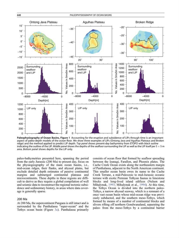
Paleophysiography of Ocean Basins, Figure 1 Accounting for the eruption and subsidence of LIPs through time is an important
aspect of paleo-depth models of the ocean floor. We show three examples of LIPs (Ontong Java and Agulhas Plateaus and Broken
ridge) and the method applied to predict LIP depth. Top panel shows present-day bathymetry from ETOPO with black outline
indicating the outline of the LIP. Middle panel shows the depths of the seafloor surrounding the LIP as well as the LIP itself per 5 Â 5 m
area. Bottom panel shows depths for the LIP only.
640
PALEOPHYSIOGRAPHY OF OCEAN BASINS