

scientists are required to synthesize the results from different disciplines in order to prove, alter, or disprove the
hypotheses they conceived. This characteristic norm of
an ocean drilling expedition, in which an international
team of scientists works around the clock for about
2 months isolated from land, offers a unique experience
to each scientist. The drillships (Chikyu and JOIDES Resolution) are equipped with laboratory equipments for shipboard scientists to conduct core sample analyses to
complete a preliminary report before returning ashore. It
is a collective, concerted, and concentrated effort for the
team on board often having to deal with contingencies
on the spot under the pressure of time.
As a drill core (typically 9.5 m long) is recovered from
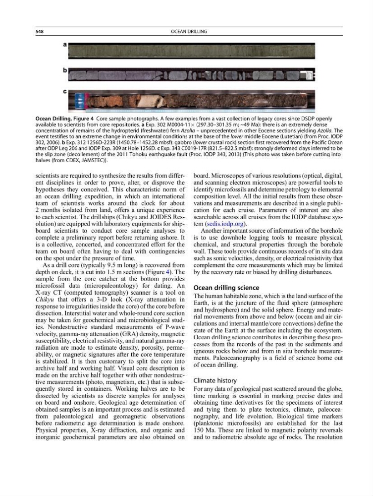
depth on deck, it is cut into 1.5 m sections (Figure 4). The
sample from the core catcher at the bottom provides
microfossil data (micropaleontology) for dating. An
X-ray CT (computed tomography) scanner is a tool on
Chikyu that offers a 3-D look (X-ray attenuation in
response to irregularities inside the core) of the core before
dissection. Interstitial water and whole-round core section
may be taken for geochemical and microbiological studies. Nondestructive standard measurements of P-wave
velocity, gamma-ray attenuation (GRA) density, magnetic
susceptibility, electrical resistivity, and natural gamma-ray
radiation are made to estimate density, porosity, permeability, or magnetic signatures after the core temperature
is stabilized. It is then customary to split the core into
archive half and working half. Visual core description is
made on the archive half together with other nondestructive measurements (photo, magnetism, etc.) that is subsequently stored in containers. Working halves are to be
dissected by scientists as discrete samples for analyses
on board and onshore. Geological age determination of
obtained samples is an important process and is estimated
from paleontological and geomagnetic observations
before radiometric age determination is made onshore.
Physical properties, X-ray diffraction, and organic and
inorganic geochemical parameters are also obtained on
board. Microscopes of various resolutions (optical, digital,
and scanning electron microscopes) are powerful tools to
identify microfossils and determine petrology to elemental
composition level. All the initial results from these observations and measurements are described in a single publication for each cruise. Parameters of interest are also
searchable across all cruises from the IODP database system (sedis.iodp.org).
Another important source of information of the borehole
is to use downhole logging tools to measure physical,
chemical, and structural properties through the borehole
wall. These tools provide continuous records of in situ data
such as sonic velocities, density, or electrical resistivity that
complement the core measurements which may be limited
by the recovery rate or biased by drilling disturbances.
Ocean drilling science
The human habitable zone, which is the land surface of the
Earth, is at the juncture of the fluid sphere (atmosphere
and hydrosphere) and the solid sphere. Energy and material movements from above and below (ocean and air circulations and internal mantle/core convections) define the
state of the Earth at the surface including the ecosystem.
Ocean drilling science contributes in describing these processes from the records of the past in the sediments and
igneous rocks below and from in situ borehole measurements. Paleoceanography is a field of science borne out
of ocean drilling.
Climate history
For any data of geological past scattered around the globe,
time marking is essential in marking precise dates and
obtaining time derivatives for the specimens of interest
and tying them to plate tectonics, climate, paleoceanography, and life evolution. Biological time markers
(planktonic microfossils) are established for the last
150 Ma. These are linked to magnetic polarity reversals
and to radiometric absolute age of rocks. The resolution
Ocean Drilling, Figure 4 Core sample photographs. A few examples from a vast collection of legacy cores since DSDP openly
available to scientists from core repositories. a Exp. 302 M0004-11Â (297.30–301.35 m; ~49 Ma): there is an extremely dense
concentration of remains of the hydropterid (freshwater) fern Azolla – unprecedented in other Eocene sections yielding Azolla. The
event testifies to an extreme change in environmental conditions at the base of the lower middle Eocene (Lutetian) (from Proc. IODP
302, 2006). b Exp. 312 1256D-223R (1450.78–1452.28 mbsf): gabbro (lower crustal rock) section first recovered from the Pacific Ocean
after ODP Leg 206 and IODP Exp. 309 at Hole 1256D. c Exp. 343 C0019-17R (821.5–822.5 mbsf): strongly deformed clays inferred to be
the slip zone (decollement) of the 2011 Tohoku earthquake fault (Proc. IODP 343, 2013) (This photo was taken before cutting into
halves (from CDEX, JAMSTEC)).
548
OCEAN DRILLING