

masses collide during continuous subduction, they
eventually merge. Telescoping of the two plates and the
buoyancy of the subducting continent eventually leads to
a standstill of subduction within the collision zone.
The oceanic part of the subducting plate tears off and continues to drop down, a process referred to as “slab
breakoff.” Continent-continent collisions ultimately result
in the formation of mountain ranges like the Himalayas or
the Alps.
Structure and topography of plate margin systems
with subduction zones
Systems of convergent plate boundaries are characterized
by a distinct topographic and geologic subdivision.
Although the plate boundary itself is only represented by
a line at the surface, commonly within a deep-sea trench,
a zone several hundreds of kilometers wide is formed by
processes which are related to subduction. The volcanic
zone above the subduction zone, in many cases expressed
as an island arc, is the dominating element of this plate
boundary system. We use arc as shorthand for the terms
volcanic arc or magmatic zone. The arc is the point of
reference for the convergent boundary that is usually
divided into three parallel zones: from the trench to the
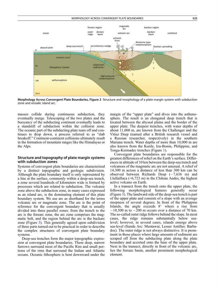
arc is the forearc zone, the arc zone comprises the magmatic belt, and the region behind the arc is the backarc
zone (Figure 3). This generally agreed upon subdivision
of three parts turned out to be practical in order to describe
the complex structures of convergent plate boundary
systems.
Deep-sea trenches form the major topographic expression at convergent plate boundaries. These deep, narrow
furrows surround most of the Pacific Rim and small portions of the rims that surround the Indian and Atlantic
oceans. Oceanic lithosphere is bent downward under the
margin of the “upper plate” and dives into the asthenosphere. The result is an elongated deep trench that is
located between the abyssal plains and the border of the
upper plate. The deepest trenches, with water depths of
about 11,000 m, are known from the Challenger and the
Vitiaz Deep (named after a British research vessel and
a Russian researcher, respectively) in the southern
Mariana trench. Water depths of more than 10,000 m are
also known from the Kurile, Izu-Bonin, Philippine, and
Tonga-Kermadec trenches (Figure 1).
Convergent plate boundaries are responsible for the
greatest differences of relief on the Earth’s surface. Differences in altitude of 10 km between the deep-sea trench and
volcanoes of the magmatic arc are not unusual. A relief of
14,300 m across a distance of less than 300 km can be
observed between Richards Deep (À7,636 m) and
Llullaillaca (+6,723 m) in the Chilean Andes, the highest
active volcano on Earth.
In a transect from the trench onto the upper plate, the
following morphological features generally occur
(Figure 3). The landward side of the deep-sea trench is part
of the upper plate and consists of a slope with an average
steepness of several degrees. In front of the Philippine
Islands, the angle exceeds 8
where a rise from
À10,500 m to À200 m occurs over a distance of 70 km.
The so-called outer ridge follows behind the slope. In most
cases, the ridge remains substantially below sealevel; however, in several cases, islands emerge above
sea-level (Sunda Arc: Mentawai; Lesser Antilles: Barbados). The outer ridge is not always distinctive. It is prominent in those places where large amounts of sediment are
scraped off from the subducting plate along the plate
boundary and accreted onto the base of the upper plate.
Next in the transect, directly in front of the volcanic arc,
lies the forearc basin, another prominent morphological
element.
Morphology Across Convergent Plate Boundaries, Figure 3 Structure and morphology of a plate margin system with subduction
zone and ensialic island arc.
MORPHOLOGY ACROSS CONVERGENT PLATE BOUNDARIES
525