

plate to the west along a twin zone of rifting in East Africa
(Figure 2b).
The northern terminus of the rift in the Afar area is
locally 155 m below sea-level and influenced by periodic
marine incursions that have led to evaporite deposits.
As the rift progressively opens, marine incursions will
progress further and further to the south along the rift axis
and converting the rift from a nonmarine to a marine basin
(Figure 2b).
The cross section in A and B from Saria et al. (2014)
shows the typical structure of East Africa with either a
half-graben structure or a full-graben structure. In inland
areas of the African continent, the rift fills are removed
from marine influence and remain continental.
Failed rift basins: basins formed by stretching
The West Siberian basin is a large failed rift system formed
by rifting during the Permian–Triassic period as the result
of a failed breakup of the northern Eurasia continent
(Mann et al., 2003). As with many failed rifts, the West
Siberian basin forms a multi-branched zone of rifting
extending hundreds of kilometers into a continental area
where fault-bounded rifts narrow and eventually
terminate.
Much of the rifted areas are overlain by a thick and less
faulted sag basin filled by marine sedimentary rocks. The
thickness of the sag basin is controlled by thermal subsidence that produces a large, bowl-shaped marine sedimentary basin overlying the underlying and elongate, parallel
rifts (Figure 3a). The sag basin is relatively symmetrical
with respect to the location of the underlying rifts that
again reflects its origin by thermal subsidence (Figure 3a).
Widespread volcanic rocks related to the lithospheric
thinning during the rifting event are present both on the
eastern rift flank and underlying the sag basin as shown
in the stippled pattern on the cross section in Figure 3b
(Reichow et al., 2002).
Collision-related basins: basins formed by flexure
Some of the largest marine and nonmarine basins formed
on continental crust are foreland basins produced by the
downward flexing of the edge of a continent in response
to the overthrusting and loading by a colliding continent,
arc, or terrane. The northern margin of the South American continent in the countries of Colombia, Venezuela,
and Trinidad provides an excellent regional example of
the continental flexure of the continental crust of the South
American plate beneath the diachronously colliding
“Great Arc of the Caribbean” (Escalona and Mann 2011)
(Figure 4). Foreland basins in this area are highly asymmetrical with the deeper edge of the foreland basin controlled by thrust faults of the colliding arc block in the
north near the coast of the Caribbean Sea and the more
gently sloping edge of the basin in the south controlled
by the flexed area of continental crust.
Marine rocks in foreland basins like the eastern Venezuelan basin were deposited during the underfilled stage
of basin development when thrusting and depression of
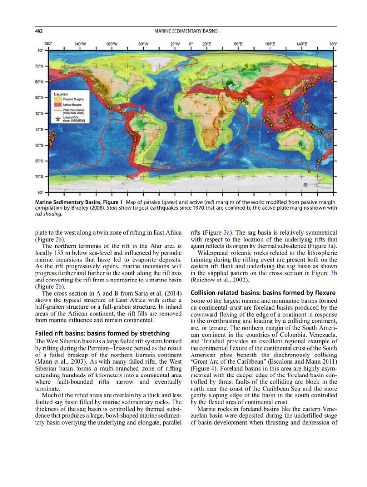
Marine Sedimentary Basins, Figure 1 Map of passive (green) and active (red) margins of the world modified from passive margin
compilation by Bradley (2008). Stars show largest earthquakes since 1970 that are confined to the active plate margins shown with
red shading.
482
MARINE SEDIMENTARY BASINS
(Figure 2b).
The northern terminus of the rift in the Afar area is
locally 155 m below sea-level and influenced by periodic
marine incursions that have led to evaporite deposits.
As the rift progressively opens, marine incursions will
progress further and further to the south along the rift axis
and converting the rift from a nonmarine to a marine basin
(Figure 2b).
The cross section in A and B from Saria et al. (2014)
shows the typical structure of East Africa with either a
half-graben structure or a full-graben structure. In inland
areas of the African continent, the rift fills are removed
from marine influence and remain continental.
Failed rift basins: basins formed by stretching
The West Siberian basin is a large failed rift system formed
by rifting during the Permian–Triassic period as the result
of a failed breakup of the northern Eurasia continent
(Mann et al., 2003). As with many failed rifts, the West
Siberian basin forms a multi-branched zone of rifting
extending hundreds of kilometers into a continental area
where fault-bounded rifts narrow and eventually
terminate.
Much of the rifted areas are overlain by a thick and less
faulted sag basin filled by marine sedimentary rocks. The
thickness of the sag basin is controlled by thermal subsidence that produces a large, bowl-shaped marine sedimentary basin overlying the underlying and elongate, parallel
rifts (Figure 3a). The sag basin is relatively symmetrical
with respect to the location of the underlying rifts that
again reflects its origin by thermal subsidence (Figure 3a).
Widespread volcanic rocks related to the lithospheric
thinning during the rifting event are present both on the
eastern rift flank and underlying the sag basin as shown
in the stippled pattern on the cross section in Figure 3b
(Reichow et al., 2002).
Collision-related basins: basins formed by flexure
Some of the largest marine and nonmarine basins formed
on continental crust are foreland basins produced by the
downward flexing of the edge of a continent in response
to the overthrusting and loading by a colliding continent,
arc, or terrane. The northern margin of the South American continent in the countries of Colombia, Venezuela,
and Trinidad provides an excellent regional example of
the continental flexure of the continental crust of the South
American plate beneath the diachronously colliding
“Great Arc of the Caribbean” (Escalona and Mann 2011)
(Figure 4). Foreland basins in this area are highly asymmetrical with the deeper edge of the foreland basin controlled by thrust faults of the colliding arc block in the
north near the coast of the Caribbean Sea and the more
gently sloping edge of the basin in the south controlled
by the flexed area of continental crust.
Marine rocks in foreland basins like the eastern Venezuelan basin were deposited during the underfilled stage
of basin development when thrusting and depression of
Marine Sedimentary Basins, Figure 1 Map of passive (green) and active (red) margins of the world modified from passive margin
compilation by Bradley (2008). Stars show largest earthquakes since 1970 that are confined to the active plate margins shown with
red shading.
482
MARINE SEDIMENTARY BASINS