

the Mid-Atlantic Ridge. The profile across the abyssal
plain between points B and C is 1,100 km long. Over this
distance, the difference in elevation is 600 m,
corresponding to a mean slope gradient of less than
0.04
, similar to shelf areas. In contrast, the continental
margins stand out with slope gradients in the range of
1–10
(in places up to 30
). The flanks of the mid-ocean
ridges show gradients of 10–20
; some seamounts stand
out as steep edifices with slopes as steep as 40
. The profile across the abyssal plain between points B and C is
1,100 km long. Over this distance, the difference in elevation is 600 m, corresponding to a mean slope gradient of
less than 0.04
. Figure 3 summarizes this information in
the form of a slope gradient map.
Sedimentation
Abyssal plains receive sediments in the form of erosional
detritus of the continents and as shell fragments of
planktonic animals and algae that live in the upper water
column of the open sea. These components form the main
constituents of the typical deep-sea or pelagic sediments in
varying relative proportions. The growth of the sediment
cover in time (the rate of sedimentation) is generally low
over abyssal plains (on the order of some cm growth in
thickness/ka), as compared to continental margins where
sedimentation rates are generally higher by a factor of
100–1,000. Given such low sedimentation rates, on abyssal plain accumulates a sediment cover of some hundred
meters. The mean thickness of the sediment cover of
abyssal plains is 450 m (Whittaker et al., 2013).
Two reasons account for the comparatively low sedimentation rate: first, the abyssal plains are largely cut off
from the main source of sedimentary particles, the erosion
of the continents. A large part of sediments that are
transported to the sea in rivers are deposited on the shelf
regions of the continents during global high stands of the
sea-level (when the shelf regions around continents are
wide). River-transported sediments surpass this “sediment
trap” easily only when rivers directly connect to submarine canyon systems, or when the shelf is narrow, or episodically at sea-level low stands or when turbidites are
shaken off. Wind transport of very fine-grained erosional
detritus (dust) is an important constituent of abyssal plain
sedimentation to the leeward side of arid regions with a
constant wind regime (such as offshore the Saharan coast
of Western Africa (Morocco, Mauretania)). Erosional detritus of larger grain size (gravel) is brought into the oceans at
high latitudes released by melting icebergs (dropstones).
Second, the bioproductivity (density of primary production) of the open seas is low in general (with the exception of zones of equatorial upwelling) because of limited
nutrient availability. Low bioproductivity results in little
and seasonally variable fallout of shell fragments and
organic material from the photic zone. In addition, only a
fraction of that export of material from the photic zone
ever reaches the seafloor, as the major part gets dissolved
or recycled in the water column. This is specifically true
for calcareous fragments that become chemically unstable
in the deep sea. The water depth underneath of which no
calcareous material is preserved in marine sediments is
called the carbonate compensation depth (CCD).
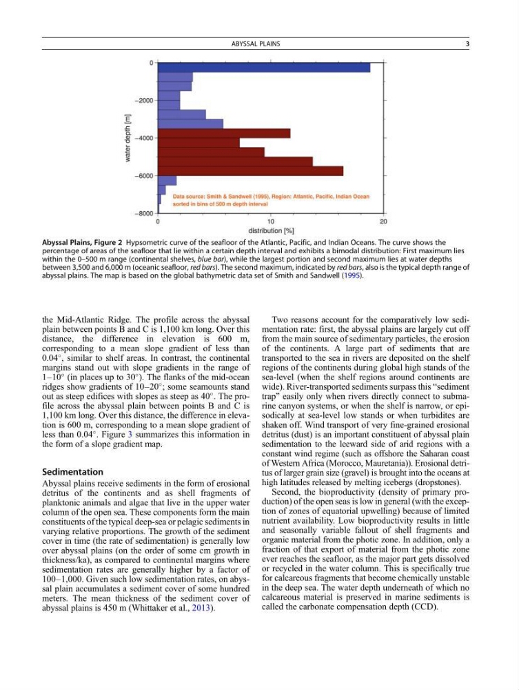
Abyssal Plains, Figure 2 Hypsometric curve of the seafloor of the Atlantic, Pacific, and Indian Oceans. The curve shows the
percentage of areas of the seafloor that lie within a certain depth interval and exhibits a bimodal distribution: First maximum lies
within the 0–500 m range (continental shelves, blue bar), while the largest portion and second maximum lies at water depths
between 3,500 and 6,000 m (oceanic seafloor, red bars). The second maximum, indicated by red bars, also is the typical depth range of
abyssal plains. The map is based on the global bathymetric data set of Smith and Sandwell (1995).
ABYSSAL PLAINS
3
plain between points B and C is 1,100 km long. Over this
distance, the difference in elevation is 600 m,
corresponding to a mean slope gradient of less than
0.04
, similar to shelf areas. In contrast, the continental
margins stand out with slope gradients in the range of
1–10
(in places up to 30
). The flanks of the mid-ocean
ridges show gradients of 10–20
; some seamounts stand
out as steep edifices with slopes as steep as 40
. The profile across the abyssal plain between points B and C is
1,100 km long. Over this distance, the difference in elevation is 600 m, corresponding to a mean slope gradient of
less than 0.04
. Figure 3 summarizes this information in
the form of a slope gradient map.
Sedimentation
Abyssal plains receive sediments in the form of erosional
detritus of the continents and as shell fragments of
planktonic animals and algae that live in the upper water
column of the open sea. These components form the main
constituents of the typical deep-sea or pelagic sediments in
varying relative proportions. The growth of the sediment
cover in time (the rate of sedimentation) is generally low
over abyssal plains (on the order of some cm growth in
thickness/ka), as compared to continental margins where
sedimentation rates are generally higher by a factor of
100–1,000. Given such low sedimentation rates, on abyssal plain accumulates a sediment cover of some hundred
meters. The mean thickness of the sediment cover of
abyssal plains is 450 m (Whittaker et al., 2013).
Two reasons account for the comparatively low sedimentation rate: first, the abyssal plains are largely cut off
from the main source of sedimentary particles, the erosion
of the continents. A large part of sediments that are
transported to the sea in rivers are deposited on the shelf
regions of the continents during global high stands of the
sea-level (when the shelf regions around continents are
wide). River-transported sediments surpass this “sediment
trap” easily only when rivers directly connect to submarine canyon systems, or when the shelf is narrow, or episodically at sea-level low stands or when turbidites are
shaken off. Wind transport of very fine-grained erosional
detritus (dust) is an important constituent of abyssal plain
sedimentation to the leeward side of arid regions with a
constant wind regime (such as offshore the Saharan coast
of Western Africa (Morocco, Mauretania)). Erosional detritus of larger grain size (gravel) is brought into the oceans at
high latitudes released by melting icebergs (dropstones).
Second, the bioproductivity (density of primary production) of the open seas is low in general (with the exception of zones of equatorial upwelling) because of limited
nutrient availability. Low bioproductivity results in little
and seasonally variable fallout of shell fragments and
organic material from the photic zone. In addition, only a
fraction of that export of material from the photic zone
ever reaches the seafloor, as the major part gets dissolved
or recycled in the water column. This is specifically true
for calcareous fragments that become chemically unstable
in the deep sea. The water depth underneath of which no
calcareous material is preserved in marine sediments is
called the carbonate compensation depth (CCD).
Abyssal Plains, Figure 2 Hypsometric curve of the seafloor of the Atlantic, Pacific, and Indian Oceans. The curve shows the
percentage of areas of the seafloor that lie within a certain depth interval and exhibits a bimodal distribution: First maximum lies
within the 0–500 m range (continental shelves, blue bar), while the largest portion and second maximum lies at water depths
between 3,500 and 6,000 m (oceanic seafloor, red bars). The second maximum, indicated by red bars, also is the typical depth range of
abyssal plains. The map is based on the global bathymetric data set of Smith and Sandwell (1995).
ABYSSAL PLAINS
3