

5. A disturbance must exist over a sufficiently broad
ocean surface to allow Coriolis acceleration to produce
horizontal trajectories that move toward a closed
circulation.
6. Since vertical wind shear can disrupt the organized
energy flow that drives a hurricane (heat taken from
the ocean surface by evaporation carried vertically
where it is released by condensation), such shear can
inhibit the formation and/or strengthening of tropical
cyclones.
Anatomy of a tropical cyclone
Tropical cyclogenesis is initiated by large areas of convection developing in warm ocean regions around the world.
Organized synoptic-scale motions (spatial scales in the
range of 10–100 s of km and temporal scales in the range
of hours to days) are typically required to initiate cyclogenesis. Features such as easterly waves, stationary fronts,
or broad areas of atmospheric divergence represent types
of disturbances which can create such organized convection. Rising air within a large area of convection begins
to create generally decreased pressures, which, in turn,
draws near-surface air from surrounding areas into the
low-pressure region. The speed of air moving over the
ocean surface directly influences the transfer rate of moisture; thus the vertical motions create a feedback which
increases the amount of heat transferred into the overriding air passing into the region of low pressure, i.e., the
faster the air moves the more moisture it accumulates.
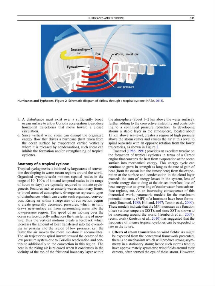
The air trajectories spiral inward toward the center of the
low pressure system due to Coriolis acceleration and contribute additionally to the convection in this region. The
heat in the rising air is released when it condenses in the
vicinity of the top of the frictional boundary layer within
the atmosphere (about 1–2 km above the water surface),
further adding to the convective instability and contributing to a continued pressure reduction. In developing
storms a stable layer in the atmosphere, located about
15 km above sea-level, creates a region of high pressure
above the storm center and causes the air at this level to
spiral outwards with an opposite rotation from the lower
trajectories, as shown in Figure 2.
Emanuel (1986, 1991) provides an excellent treatise on
the formation of tropical cyclones in terms of a Carnot
engine that converts the heat from evaporation at the ocean
surface into mechanical energy. This energy cycle can
continue to grow in strength as long as the rate of gain of
heat (from the ocean into the atmosphere) from the evaporation at the surface and condensation in the cloud layer
exceeds the sum of energy losses in the system, loss of
kinetic energy due to drag at the air-sea interface, loss of
heat energy due to upwelling of cooler water from subsurface regions, etc. As an interesting consequence of this
theoretical work, parametric models for the maximum
potential intensity (MPI) of a hurricane have been formulated (Emanuel, 1988; Holland, 1997; Tonkin et al., 2000).
These models indicate that the MPI increases as a function
of sea surface temperate (SST); and since SST is known to
be increasing around the world (Trenberth et al., 2007),
recent work (Knutson et al., 2010) has suggested that the
frequency of intense tropical cyclones can be expected to
rise in the future.
• Effects of storm translation on wind fields: As might
be expected from the conceptual framework presented,
there is no mechanism which will produce strong asymmetry in a stationary storm; hence such storms tend to
have approximately symmetric wind fields around their
centers, often termed the eye of these storm. However,
Hurricanes and Typhoons, Figure 2 Schematic diagram of airflow through a tropical cyclone (NASA, 2013).
HURRICANES AND TYPHOONS
331
ocean surface to allow Coriolis acceleration to produce
horizontal trajectories that move toward a closed
circulation.
6. Since vertical wind shear can disrupt the organized
energy flow that drives a hurricane (heat taken from
the ocean surface by evaporation carried vertically
where it is released by condensation), such shear can
inhibit the formation and/or strengthening of tropical
cyclones.
Anatomy of a tropical cyclone
Tropical cyclogenesis is initiated by large areas of convection developing in warm ocean regions around the world.
Organized synoptic-scale motions (spatial scales in the
range of 10–100 s of km and temporal scales in the range
of hours to days) are typically required to initiate cyclogenesis. Features such as easterly waves, stationary fronts,
or broad areas of atmospheric divergence represent types
of disturbances which can create such organized convection. Rising air within a large area of convection begins
to create generally decreased pressures, which, in turn,
draws near-surface air from surrounding areas into the
low-pressure region. The speed of air moving over the
ocean surface directly influences the transfer rate of moisture; thus the vertical motions create a feedback which
increases the amount of heat transferred into the overriding air passing into the region of low pressure, i.e., the
faster the air moves the more moisture it accumulates.
The air trajectories spiral inward toward the center of the
low pressure system due to Coriolis acceleration and contribute additionally to the convection in this region. The
heat in the rising air is released when it condenses in the
vicinity of the top of the frictional boundary layer within
the atmosphere (about 1–2 km above the water surface),
further adding to the convective instability and contributing to a continued pressure reduction. In developing
storms a stable layer in the atmosphere, located about
15 km above sea-level, creates a region of high pressure
above the storm center and causes the air at this level to
spiral outwards with an opposite rotation from the lower
trajectories, as shown in Figure 2.
Emanuel (1986, 1991) provides an excellent treatise on
the formation of tropical cyclones in terms of a Carnot
engine that converts the heat from evaporation at the ocean
surface into mechanical energy. This energy cycle can
continue to grow in strength as long as the rate of gain of
heat (from the ocean into the atmosphere) from the evaporation at the surface and condensation in the cloud layer
exceeds the sum of energy losses in the system, loss of
kinetic energy due to drag at the air-sea interface, loss of
heat energy due to upwelling of cooler water from subsurface regions, etc. As an interesting consequence of this
theoretical work, parametric models for the maximum
potential intensity (MPI) of a hurricane have been formulated (Emanuel, 1988; Holland, 1997; Tonkin et al., 2000).
These models indicate that the MPI increases as a function
of sea surface temperate (SST); and since SST is known to
be increasing around the world (Trenberth et al., 2007),
recent work (Knutson et al., 2010) has suggested that the
frequency of intense tropical cyclones can be expected to
rise in the future.
• Effects of storm translation on wind fields: As might
be expected from the conceptual framework presented,
there is no mechanism which will produce strong asymmetry in a stationary storm; hence such storms tend to
have approximately symmetric wind fields around their
centers, often termed the eye of these storm. However,
Hurricanes and Typhoons, Figure 2 Schematic diagram of airflow through a tropical cyclone (NASA, 2013).
HURRICANES AND TYPHOONS
331