

z points vertically away from Earth’s rotational axis with
O being the angular velocity, j the geographic latitude,
and R Earth’s radius.
The resulting acceleration of gravity is
g ¼ 982,037 À 3,389cos
2
j
ð
Þ mGal with mGal ¼ 10
À5 m=s
2
for the simplifying assumption that Earth has the shape of
a sphere. As a result of the latitude dependence, g is
smaller at the equator than at the poles.
Another effect of the centrifugal forces is that Earth’s
body is not a perfect sphere, but has a bulge at the equator
and in first approximation has the shape of a spheroid. The
commonly used model for the reference spheroid is the
WGS84 (Stacey, 1992) which uses the following values:
Equatorial radius 6,378,136 m
Polar radius 6,356,751 m
Flattening 1/298.257
The International Union for Geodesy and Geophysics
(IUGG) has set the following formula for the gravity on
the spheroid (Stacey, 1992):
g 0 ¼ 978, 032:7 1 þ 0:0053024 sin
2 j
À
À0:0000058 sin
2 2j
Á
mGal
where j is the geographical latitude.
An even better approximation of the Earth is the
so-called geoid which reflects the deviations from the
rotationally symmetric shape of the reference spheroid.
The deviations are on the order of a few tens of meters
and only in the area south of India reach a value of more
than 100 m. The geoid can be described with spherical
functions, which has recently been done to degree and
order 2,159 (Pavlis et al., 2012). Over the oceans, the surface of the geoid is equivalent to the mean sea surface.
Measurements
The classical way of measuring gravity on the sea surface
is by using straight line gravity meters which are installed
on board of ships to measure the vertical component of the
gravity field. A marine gravity meter typically consists of
a gyrostabilized platform and a gravity sensor. Different
types of sensors are in use, most of which have a mass that
is suspended on a metal spring to measure local differences in gravity. Thus, they measure relative differences
which have to be tied to a point of known absolute gravity
in a harbor. Similar instruments are being used on aircrafts
as well.
As an example, the Sea-Air-Gravimeter System
KSS32M (BGGS GmbH, Meersburg, Germany) consists
of a gravity sensor, a gyrostabilized platform containing
the power supply and all electronics for gravimeter and
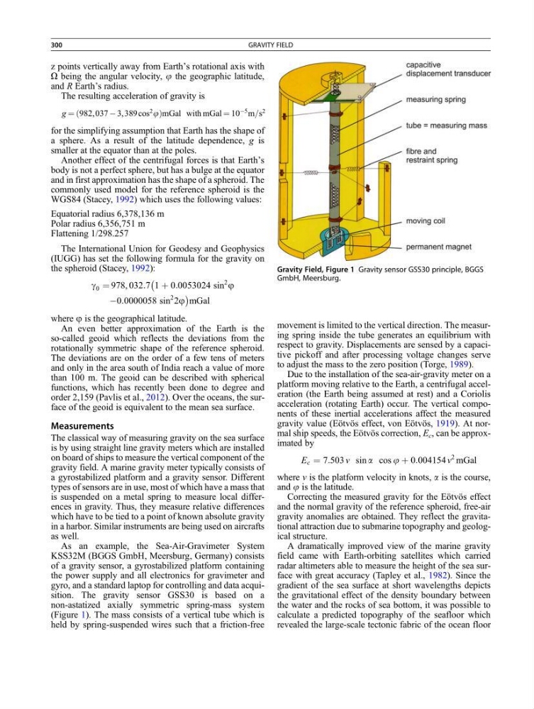
gyro, and a standard laptop for controlling and data acquisition. The gravity sensor GSS30 is based on a
non-astatized axially symmetric spring-mass system
(Figure 1). The mass consists of a vertical tube which is
held by spring-suspended wires such that a friction-free
movement is limited to the vertical direction. The measuring spring inside the tube generates an equilibrium with
respect to gravity. Displacements are sensed by a capacitive pickoff and after processing voltage changes serve
to adjust the mass to the zero position (Torge, 1989).
Due to the installation of the sea-air-gravity meter on a
platform moving relative to the Earth, a centrifugal acceleration (the Earth being assumed at rest) and a Coriolis
acceleration (rotating Earth) occur. The vertical components of these inertial accelerations affect the measured
gravity value (Eötvös effect, von Eötvös, 1919). At normal ship speeds, the Eötvös correction, E c , can be approximated by
E c ¼ 7:503 v sin a cos j þ 0:004154 v
2 mGal
where v is the platform velocity in knots, a is the course,
and j is the latitude.
Correcting the measured gravity for the Eötvös effect
and the normal gravity of the reference spheroid, free-air
gravity anomalies are obtained. They reflect the gravitational attraction due to submarine topography and geological structure.
A dramatically improved view of the marine gravity
field came with Earth-orbiting satellites which carried
radar altimeters able to measure the height of the sea surface with great accuracy (Tapley et al., 1982). Since the
gradient of the sea surface at short wavelengths depicts
the gravitational effect of the density boundary between
the water and the rocks of sea bottom, it was possible to
calculate a predicted topography of the seafloor which
revealed the large-scale tectonic fabric of the ocean floor
Gravity Field, Figure 1 Gravity sensor GSS30 principle, BGGS
GmbH, Meersburg.
300
GRAVITY FIELD
O being the angular velocity, j the geographic latitude,
and R Earth’s radius.
The resulting acceleration of gravity is
g ¼ 982,037 À 3,389cos
2
j
ð
Þ mGal with mGal ¼ 10
À5 m=s
2
for the simplifying assumption that Earth has the shape of
a sphere. As a result of the latitude dependence, g is
smaller at the equator than at the poles.
Another effect of the centrifugal forces is that Earth’s
body is not a perfect sphere, but has a bulge at the equator
and in first approximation has the shape of a spheroid. The
commonly used model for the reference spheroid is the
WGS84 (Stacey, 1992) which uses the following values:
Equatorial radius 6,378,136 m
Polar radius 6,356,751 m
Flattening 1/298.257
The International Union for Geodesy and Geophysics
(IUGG) has set the following formula for the gravity on
the spheroid (Stacey, 1992):
g 0 ¼ 978, 032:7 1 þ 0:0053024 sin
2 j
À
À0:0000058 sin
2 2j
Á
mGal
where j is the geographical latitude.
An even better approximation of the Earth is the
so-called geoid which reflects the deviations from the
rotationally symmetric shape of the reference spheroid.
The deviations are on the order of a few tens of meters
and only in the area south of India reach a value of more
than 100 m. The geoid can be described with spherical
functions, which has recently been done to degree and
order 2,159 (Pavlis et al., 2012). Over the oceans, the surface of the geoid is equivalent to the mean sea surface.
Measurements
The classical way of measuring gravity on the sea surface
is by using straight line gravity meters which are installed
on board of ships to measure the vertical component of the
gravity field. A marine gravity meter typically consists of
a gyrostabilized platform and a gravity sensor. Different
types of sensors are in use, most of which have a mass that
is suspended on a metal spring to measure local differences in gravity. Thus, they measure relative differences
which have to be tied to a point of known absolute gravity
in a harbor. Similar instruments are being used on aircrafts
as well.
As an example, the Sea-Air-Gravimeter System
KSS32M (BGGS GmbH, Meersburg, Germany) consists
of a gravity sensor, a gyrostabilized platform containing
the power supply and all electronics for gravimeter and
gyro, and a standard laptop for controlling and data acquisition. The gravity sensor GSS30 is based on a
non-astatized axially symmetric spring-mass system
(Figure 1). The mass consists of a vertical tube which is
held by spring-suspended wires such that a friction-free
movement is limited to the vertical direction. The measuring spring inside the tube generates an equilibrium with
respect to gravity. Displacements are sensed by a capacitive pickoff and after processing voltage changes serve
to adjust the mass to the zero position (Torge, 1989).
Due to the installation of the sea-air-gravity meter on a
platform moving relative to the Earth, a centrifugal acceleration (the Earth being assumed at rest) and a Coriolis
acceleration (rotating Earth) occur. The vertical components of these inertial accelerations affect the measured
gravity value (Eötvös effect, von Eötvös, 1919). At normal ship speeds, the Eötvös correction, E c , can be approximated by
E c ¼ 7:503 v sin a cos j þ 0:004154 v
2 mGal
where v is the platform velocity in knots, a is the course,
and j is the latitude.
Correcting the measured gravity for the Eötvös effect
and the normal gravity of the reference spheroid, free-air
gravity anomalies are obtained. They reflect the gravitational attraction due to submarine topography and geological structure.
A dramatically improved view of the marine gravity
field came with Earth-orbiting satellites which carried
radar altimeters able to measure the height of the sea surface with great accuracy (Tapley et al., 1982). Since the
gradient of the sea surface at short wavelengths depicts
the gravitational effect of the density boundary between
the water and the rocks of sea bottom, it was possible to
calculate a predicted topography of the seafloor which
revealed the large-scale tectonic fabric of the ocean floor
Gravity Field, Figure 1 Gravity sensor GSS30 principle, BGGS
GmbH, Meersburg.
300
GRAVITY FIELD