

18.6 kg m
À2 day
À1 (Trusel et al., 2010). Studies in
Billefjorden, a subpolar fjord in Svalbard, demonstrate
that vertical downward particulate matter fluxes can reach
up to several kg m
À2 d
À1 in subpolar non-glacier contact
and glacier contact setting during the short summer season
(Szczucinski and Zajaczkowski, 2012).
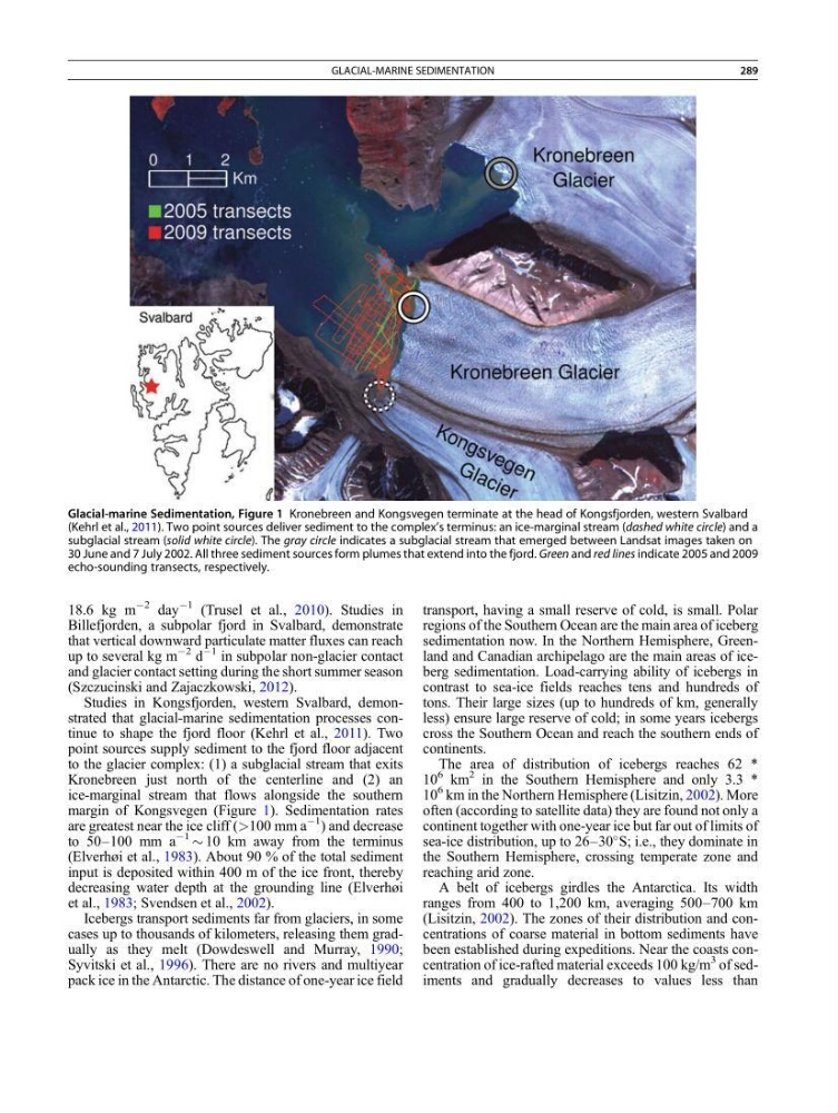
Studies in Kongsfjorden, western Svalbard, demonstrated that glacial-marine sedimentation processes continue to shape the fjord floor (Kehrl et al., 2011). Two
point sources supply sediment to the fjord floor adjacent
to the glacier complex: (1) a subglacial stream that exits
Kronebreen just north of the centerline and (2) an
ice-marginal stream that flows alongside the southern
margin of Kongsvegen (Figure 1). Sedimentation rates
are greatest near the ice cliff (>100 mm a
À1
) and decrease
to 50–100 mm a
À1
$ 10 km away from the terminus
(Elverhøi et al., 1983). About 90 % of the total sediment
input is deposited within 400 m of the ice front, thereby
decreasing water depth at the grounding line (Elverhøi
et al., 1983; Svendsen et al., 2002).
Icebergs transport sediments far from glaciers, in some
cases up to thousands of kilometers, releasing them gradually as they melt (Dowdeswell and Murray, 1990;
Syvitski et al., 1996). There are no rivers and multiyear
pack ice in the Antarctic. The distance of one-year ice field
transport, having a small reserve of cold, is small. Polar
regions of the Southern Ocean are the main area of iceberg
sedimentation now. In the Northern Hemisphere, Greenland and Canadian archipelago are the main areas of iceberg sedimentation. Load-carrying ability of icebergs in
contrast to sea-ice fields reaches tens and hundreds of
tons. Their large sizes (up to hundreds of km, generally
less) ensure large reserve of cold; in some years icebergs
cross the Southern Ocean and reach the southern ends of
continents.
The area of distribution of icebergs reaches 62 *
10
6 km
2 in the Southern Hemisphere and only 3.3 *
10
6 km in the Northern Hemisphere (Lisitzin, 2002). More
often (according to satellite data) they are found not only a
continent together with one-year ice but far out of limits of
sea-ice distribution, up to 26–30
S; i.e., they dominate in
the Southern Hemisphere, crossing temperate zone and
reaching arid zone.
A belt of icebergs girdles the Antarctica. Its width
ranges from 400 to 1,200 km, averaging 500–700 km
(Lisitzin, 2002). The zones of their distribution and concentrations of coarse material in bottom sediments have
been established during expeditions. Near the coasts concentration of ice-rafted material exceeds 100 kg/m
3 of sediments and gradually decreases to values less than
Glacial-marine Sedimentation, Figure 1 Kronebreen and Kongsvegen terminate at the head of Kongsfjorden, western Svalbard
(Kehrl et al., 2011). Two point sources deliver sediment to the complex’s terminus: an ice-marginal stream (dashed white circle) and a
subglacial stream (solid white circle). The gray circle indicates a subglacial stream that emerged between Landsat images taken on
30 June and 7 July 2002. All three sediment sources form plumes that extend into the fjord. Green and red lines indicate 2005 and 2009
echo-sounding transects, respectively.
GLACIAL-MARINE SEDIMENTATION
289
À2 day
À1 (Trusel et al., 2010). Studies in
Billefjorden, a subpolar fjord in Svalbard, demonstrate
that vertical downward particulate matter fluxes can reach
up to several kg m
À2 d
À1 in subpolar non-glacier contact
and glacier contact setting during the short summer season
(Szczucinski and Zajaczkowski, 2012).
Studies in Kongsfjorden, western Svalbard, demonstrated that glacial-marine sedimentation processes continue to shape the fjord floor (Kehrl et al., 2011). Two
point sources supply sediment to the fjord floor adjacent
to the glacier complex: (1) a subglacial stream that exits
Kronebreen just north of the centerline and (2) an
ice-marginal stream that flows alongside the southern
margin of Kongsvegen (Figure 1). Sedimentation rates
are greatest near the ice cliff (>100 mm a
À1
) and decrease
to 50–100 mm a
À1
$ 10 km away from the terminus
(Elverhøi et al., 1983). About 90 % of the total sediment
input is deposited within 400 m of the ice front, thereby
decreasing water depth at the grounding line (Elverhøi
et al., 1983; Svendsen et al., 2002).
Icebergs transport sediments far from glaciers, in some
cases up to thousands of kilometers, releasing them gradually as they melt (Dowdeswell and Murray, 1990;
Syvitski et al., 1996). There are no rivers and multiyear
pack ice in the Antarctic. The distance of one-year ice field
transport, having a small reserve of cold, is small. Polar
regions of the Southern Ocean are the main area of iceberg
sedimentation now. In the Northern Hemisphere, Greenland and Canadian archipelago are the main areas of iceberg sedimentation. Load-carrying ability of icebergs in
contrast to sea-ice fields reaches tens and hundreds of
tons. Their large sizes (up to hundreds of km, generally
less) ensure large reserve of cold; in some years icebergs
cross the Southern Ocean and reach the southern ends of
continents.
The area of distribution of icebergs reaches 62 *
10
6 km
2 in the Southern Hemisphere and only 3.3 *
10
6 km in the Northern Hemisphere (Lisitzin, 2002). More
often (according to satellite data) they are found not only a
continent together with one-year ice but far out of limits of
sea-ice distribution, up to 26–30
S; i.e., they dominate in
the Southern Hemisphere, crossing temperate zone and
reaching arid zone.
A belt of icebergs girdles the Antarctica. Its width
ranges from 400 to 1,200 km, averaging 500–700 km
(Lisitzin, 2002). The zones of their distribution and concentrations of coarse material in bottom sediments have
been established during expeditions. Near the coasts concentration of ice-rafted material exceeds 100 kg/m
3 of sediments and gradually decreases to values less than
Glacial-marine Sedimentation, Figure 1 Kronebreen and Kongsvegen terminate at the head of Kongsfjorden, western Svalbard
(Kehrl et al., 2011). Two point sources deliver sediment to the complex’s terminus: an ice-marginal stream (dashed white circle) and a
subglacial stream (solid white circle). The gray circle indicates a subglacial stream that emerged between Landsat images taken on
30 June and 7 July 2002. All three sediment sources form plumes that extend into the fjord. Green and red lines indicate 2005 and 2009
echo-sounding transects, respectively.
GLACIAL-MARINE SEDIMENTATION
289