

Tide-dominated deltas are shaped by onshore-offshore
sediment transport caused by reversing tidal currents.
They occur primarily in funnel-shaped, macro-tidal
embayments, such as the Kuskokwim Delta in the Alaskan
Bering Sea or the mouth of the Elbe River in the German
Bight. Fine-grained sediment that enters the embayment
is deposited offshore and along the borders of the estuary
forming broad tidal flats transitioning into wetland areas
(2–10s km wide) (Table 2). Riverine-derived coarse sediment is transported offshore, reworked by tidal currents,
and deposited as linear sand shoals, also called tidal
ridges. These features are usually subtidal with a relief of
several meters, greater than 0.5 km wide, and 5–20 km
in length. It appears that under very high sediment discharge conditions, such as at the mouth of the Fly River
in Papua New Guinea, elongated channel-parallel islands
have developed that are up to 60 km long and 5–10 km
wide (Canestrelli et al., 2010).
A fundamental sedimentologic difference between
wave- and tide-dominated deltas is that tide-dominated
systems formed sand bodies oriented shore normal,
whereas wave-dominated deltas contain sand bodies
trending parallel to shore. The bulk of sand contained
within river-dominated deltas is associated with distributary channels, and thus, these sand bodies are sinuous
and oriented normal to oblique to shore (Rich, 1923).
Modern deltas
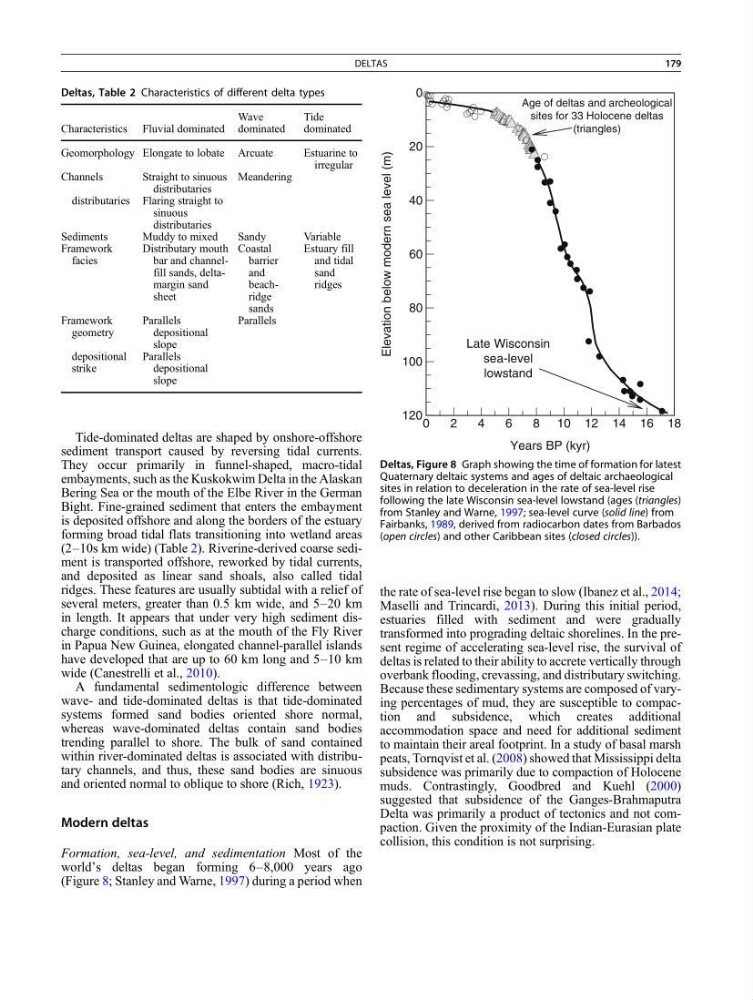
Formation, sea-level, and sedimentation Most of the
world’s deltas began forming 6–8,000 years ago
(Figure 8; Stanley and Warne, 1997) during a period when
the rate of sea-level rise began to slow (Ibanez et al., 2014;
Maselli and Trincardi, 2013). During this initial period,
estuaries filled with sediment and were gradually
transformed into prograding deltaic shorelines. In the present regime of accelerating sea-level rise, the survival of
deltas is related to their ability to accrete vertically through
overbank flooding, crevassing, and distributary switching.
Because these sedimentary systems are composed of varying percentages of mud, they are susceptible to compaction and subsidence, which creates additional
accommodation space and need for additional sediment
to maintain their areal footprint. In a study of basal marsh
peats, Tornqvist et al. (2008) showed that Mississippi delta
subsidence was primarily due to compaction of Holocene
muds. Contrastingly, Goodbred and Kuehl (2000)
suggested that subsidence of the Ganges-Brahmaputra
Delta was primarily a product of tectonics and not compaction. Given the proximity of the Indian-Eurasian plate
collision, this condition is not surprising.
Deltas, Table 2 Characteristics of different delta types
Characteristics Fluvial dominated
Wave
dominated
Tide
dominated
Geomorphology Elongate to lobate Arcuate
Estuarine to
irregular
Channels
Straight to sinuous
distributaries
Meandering
distributaries Flaring straight to
sinuous
distributaries
Sediments
Muddy to mixed
Sandy
Variable
Framework
facies
Distributary mouth
bar and channelfill sands, deltamargin sand
sheet
Coastal
barrier
and
beachridge
sands
Estuary fill
and tidal
sand
ridges
Framework
geometry
Parallels
depositional
slope
Parallels
depositional
strike
Parallels
depositional
slope
Years BP (kyr)
Elevation below modern sea level (m)
0
2
4
6
8 10 12 14 16 18
0
20
40
60
80
100
120
Age of deltas and archeological
sites for 33 Holocene deltas
(triangles)
Late Wisconsin
sea-level
lowstand
Deltas, Figure 8 Graph showing the time of formation for latest
Quaternary deltaic systems and ages of deltaic archaeological
sites in relation to deceleration in the rate of sea-level rise
following the late Wisconsin sea-level lowstand (ages (triangles)
from Stanley and Warne, 1997; sea-level curve (solid line) from
Fairbanks, 1989, derived from radiocarbon dates from Barbados
(open circles) and other Caribbean sites (closed circles)).
DELTAS
179
sediment transport caused by reversing tidal currents.
They occur primarily in funnel-shaped, macro-tidal
embayments, such as the Kuskokwim Delta in the Alaskan
Bering Sea or the mouth of the Elbe River in the German
Bight. Fine-grained sediment that enters the embayment
is deposited offshore and along the borders of the estuary
forming broad tidal flats transitioning into wetland areas
(2–10s km wide) (Table 2). Riverine-derived coarse sediment is transported offshore, reworked by tidal currents,
and deposited as linear sand shoals, also called tidal
ridges. These features are usually subtidal with a relief of
several meters, greater than 0.5 km wide, and 5–20 km
in length. It appears that under very high sediment discharge conditions, such as at the mouth of the Fly River
in Papua New Guinea, elongated channel-parallel islands
have developed that are up to 60 km long and 5–10 km
wide (Canestrelli et al., 2010).
A fundamental sedimentologic difference between
wave- and tide-dominated deltas is that tide-dominated
systems formed sand bodies oriented shore normal,
whereas wave-dominated deltas contain sand bodies
trending parallel to shore. The bulk of sand contained
within river-dominated deltas is associated with distributary channels, and thus, these sand bodies are sinuous
and oriented normal to oblique to shore (Rich, 1923).
Modern deltas
Formation, sea-level, and sedimentation Most of the
world’s deltas began forming 6–8,000 years ago
(Figure 8; Stanley and Warne, 1997) during a period when
the rate of sea-level rise began to slow (Ibanez et al., 2014;
Maselli and Trincardi, 2013). During this initial period,
estuaries filled with sediment and were gradually
transformed into prograding deltaic shorelines. In the present regime of accelerating sea-level rise, the survival of
deltas is related to their ability to accrete vertically through
overbank flooding, crevassing, and distributary switching.
Because these sedimentary systems are composed of varying percentages of mud, they are susceptible to compaction and subsidence, which creates additional
accommodation space and need for additional sediment
to maintain their areal footprint. In a study of basal marsh
peats, Tornqvist et al. (2008) showed that Mississippi delta
subsidence was primarily due to compaction of Holocene
muds. Contrastingly, Goodbred and Kuehl (2000)
suggested that subsidence of the Ganges-Brahmaputra
Delta was primarily a product of tectonics and not compaction. Given the proximity of the Indian-Eurasian plate
collision, this condition is not surprising.
Deltas, Table 2 Characteristics of different delta types
Characteristics Fluvial dominated
Wave
dominated
Tide
dominated
Geomorphology Elongate to lobate Arcuate
Estuarine to
irregular
Channels
Straight to sinuous
distributaries
Meandering
distributaries Flaring straight to
sinuous
distributaries
Sediments
Muddy to mixed
Sandy
Variable
Framework
facies
Distributary mouth
bar and channelfill sands, deltamargin sand
sheet
Coastal
barrier
and
beachridge
sands
Estuary fill
and tidal
sand
ridges
Framework
geometry
Parallels
depositional
slope
Parallels
depositional
strike
Parallels
depositional
slope
Years BP (kyr)
Elevation below modern sea level (m)
0
2
4
6
8 10 12 14 16 18
0
20
40
60
80
100
120
Age of deltas and archeological
sites for 33 Holocene deltas
(triangles)
Late Wisconsin
sea-level
lowstand
Deltas, Figure 8 Graph showing the time of formation for latest
Quaternary deltaic systems and ages of deltaic archaeological
sites in relation to deceleration in the rate of sea-level rise
following the late Wisconsin sea-level lowstand (ages (triangles)
from Stanley and Warne, 1997; sea-level curve (solid line) from
Fairbanks, 1989, derived from radiocarbon dates from Barbados
(open circles) and other Caribbean sites (closed circles)).
DELTAS
179