

along marginal-sea coasts, and 8.6 % on collision
(leading-edge) coasts.
Trailing-edge coasts provide a geologic setting favorable to delta development because of their tectonic stability and geologically old, low-relict terrains with extensive
river systems that provide an abundant supply of sediment. Moreover, trailing-edge coasts often border broad
continental shelves, which provide shallow-water platforms for the formation of deltas. Marginal-sea coasts typically provide relatively low-energy settings with many
trailing coast characteristics that are conducive to delta
development. Mountainous and immature drainage systems of tectonically active, leading-edge coasts (Pacific
coast of South America) with small catchment basins
and low sediment supply generally limit the likelihood
of extensive deltaic deposition. However, it is the mountains of tectonically active coastal margins (e.g., Andes)
or former coastal margins and present subduction zones
(Himalayas) that can supply vast amounts of sediment to
trailing-edge margin deltas (e.g., Amazon and GangesBrahmaputra, respectively). Figure 1 shows the locations
and Table 1 lists the sizes of the world’s 25 largest deltaic
systems, according to McKee (2005) and Meade (1996).
Delta types and formation
Previous summaries of the world’s deltas have focused
primarily on the major large deltas (e.g., Coleman and
Wright, 1975). A review of the recent literature on Late
Quaternary deltaic systems reveals that deltas can be classified into four basic types depending on sea-level position
(highstand or lowstand) and sediment supply (high or low)
(Kindinger, 1988; Boyd et al., 1989; Nichol et al., 1996).
The four basic types of deltas include: (1) lacustrine,
(2) bayhead (or lagoonal), (3) continental shelf, and
(4) continental margin. In a geomorphic and evolutionary
sense, these four types of deltas represent end members
and transitional forms describe many deltas. For example,
during a sufficiently long sea-level stillstand, a lacustrine
deltaic system having an adequate sediment supply and
wave and tidal setting could evolve into a continental shelf
margin deltaic system through progradation.
Lacustrine deltas
A lacustrine delta consists of sedimentary deposits located
landward of the coast or paralic zone within an inland lake
or small inland sea. In these cases, the environmental setting is typically a shallow-water basin with a low-energy
regime. Along the Gulf of Mexico, the best example of a
lacustrine delta is the Grand Lake delta within the Atchafalaya drainage basin of south-central Louisiana. At the
start of the nineteenth century, Grand Lake, within the
Atchafalaya basin, was a shallow, low-energy lake (Tye
and Coleman, 1989). However, by the 1950s a large lacustrine delta had filled this lake and started conveying its
sediment load into the Atchafalaya Bay. This rapid
infilling largely resulted from the progressively increasing
Mississippi River flow into the Atchafalaya basin (van
Heerden and Roberts, 1988). Historically, if left
uncontrolled, the Mississippi River would have avulsed
from its modern course into the Gulf of Mexico past
New Orleans to the Atchafalaya course located farther
west. Other lacustrine delta examples include deltas in
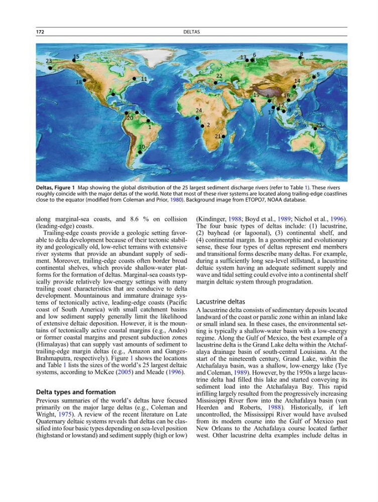
Deltas, Figure 1 Map showing the global distribution of the 25 largest sediment discharge rivers (refer to Table 1). These rivers
roughly coincide with the major deltas of the world. Note that most of these river systems are located along trailing-edge coastlines
close to the equator (modified from Coleman and Prior, 1980). Background image from ETOPO7, NOAA database.
172
DELTAS
(leading-edge) coasts.
Trailing-edge coasts provide a geologic setting favorable to delta development because of their tectonic stability and geologically old, low-relict terrains with extensive
river systems that provide an abundant supply of sediment. Moreover, trailing-edge coasts often border broad
continental shelves, which provide shallow-water platforms for the formation of deltas. Marginal-sea coasts typically provide relatively low-energy settings with many
trailing coast characteristics that are conducive to delta
development. Mountainous and immature drainage systems of tectonically active, leading-edge coasts (Pacific
coast of South America) with small catchment basins
and low sediment supply generally limit the likelihood
of extensive deltaic deposition. However, it is the mountains of tectonically active coastal margins (e.g., Andes)
or former coastal margins and present subduction zones
(Himalayas) that can supply vast amounts of sediment to
trailing-edge margin deltas (e.g., Amazon and GangesBrahmaputra, respectively). Figure 1 shows the locations
and Table 1 lists the sizes of the world’s 25 largest deltaic
systems, according to McKee (2005) and Meade (1996).
Delta types and formation
Previous summaries of the world’s deltas have focused
primarily on the major large deltas (e.g., Coleman and
Wright, 1975). A review of the recent literature on Late
Quaternary deltaic systems reveals that deltas can be classified into four basic types depending on sea-level position
(highstand or lowstand) and sediment supply (high or low)
(Kindinger, 1988; Boyd et al., 1989; Nichol et al., 1996).
The four basic types of deltas include: (1) lacustrine,
(2) bayhead (or lagoonal), (3) continental shelf, and
(4) continental margin. In a geomorphic and evolutionary
sense, these four types of deltas represent end members
and transitional forms describe many deltas. For example,
during a sufficiently long sea-level stillstand, a lacustrine
deltaic system having an adequate sediment supply and
wave and tidal setting could evolve into a continental shelf
margin deltaic system through progradation.
Lacustrine deltas
A lacustrine delta consists of sedimentary deposits located
landward of the coast or paralic zone within an inland lake
or small inland sea. In these cases, the environmental setting is typically a shallow-water basin with a low-energy
regime. Along the Gulf of Mexico, the best example of a
lacustrine delta is the Grand Lake delta within the Atchafalaya drainage basin of south-central Louisiana. At the
start of the nineteenth century, Grand Lake, within the
Atchafalaya basin, was a shallow, low-energy lake (Tye
and Coleman, 1989). However, by the 1950s a large lacustrine delta had filled this lake and started conveying its
sediment load into the Atchafalaya Bay. This rapid
infilling largely resulted from the progressively increasing
Mississippi River flow into the Atchafalaya basin (van
Heerden and Roberts, 1988). Historically, if left
uncontrolled, the Mississippi River would have avulsed
from its modern course into the Gulf of Mexico past
New Orleans to the Atchafalaya course located farther
west. Other lacustrine delta examples include deltas in
Deltas, Figure 1 Map showing the global distribution of the 25 largest sediment discharge rivers (refer to Table 1). These rivers
roughly coincide with the major deltas of the world. Note that most of these river systems are located along trailing-edge coastlines
close to the equator (modified from Coleman and Prior, 1980). Background image from ETOPO7, NOAA database.
172
DELTAS