

conditions, clay mineral data determined in marine sediment cores were used to reconstruct the paleoceanographic and paleoclimatic changes through time, as
shown in numerous studies from different parts of the
world ocean (e.g., Janecek and Rea, 1983; Stein and
Robert, 1985; Stein, 1985; Ehrmann et al., 1992; Robert
and Kennett, 1994; Stein, 2008).
In polar and subpolar regions, with predominantly cold
climate at least during Neogene and Quaternary times,
physical weathering processes dominate and chemical
and diagenetic alterations are negligible. Therefore, the
clay mineral association in marine sediments is a valuable
indicator to identify origin and transport pathways of terrigenous sediments, and clay mineral data were used to
distinguish among the shelf areas by the amounts of smectite, illite, and kaolinite in surface sediments (see Stein,
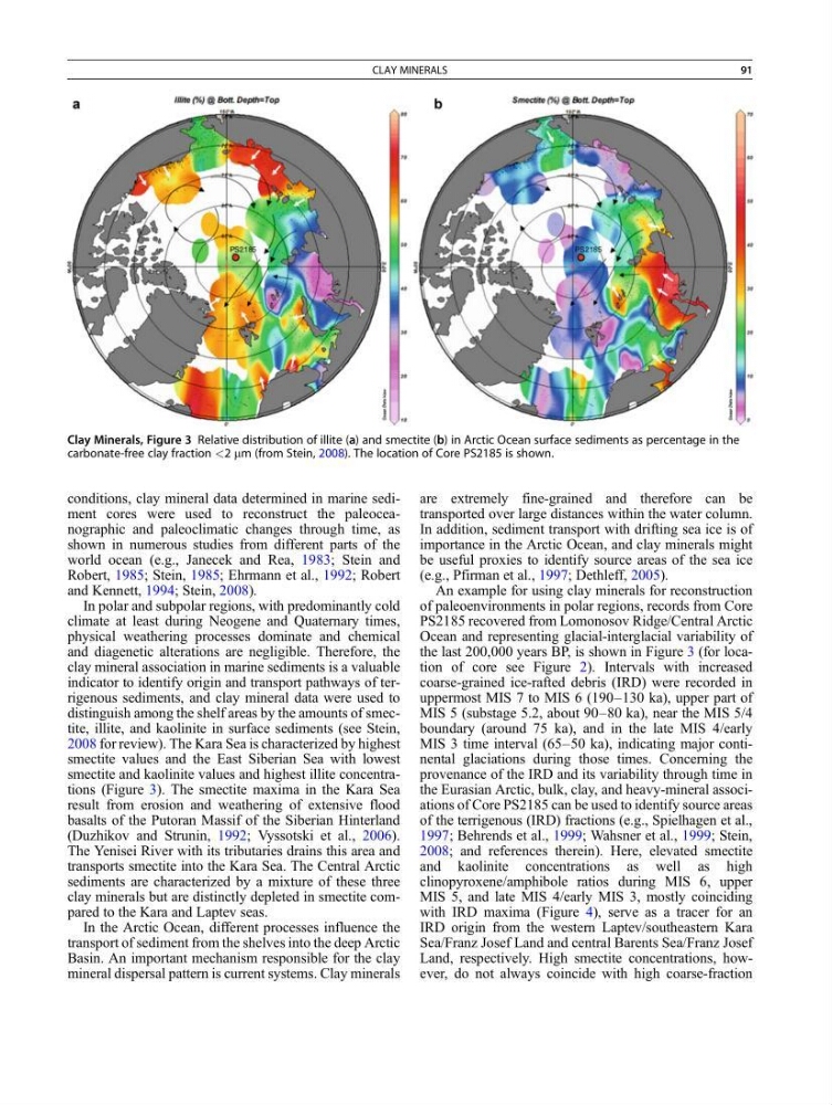
2008 for review). The Kara Sea is characterized by highest
smectite values and the East Siberian Sea with lowest
smectite and kaolinite values and highest illite concentrations (Figure 3). The smectite maxima in the Kara Sea
result from erosion and weathering of extensive flood
basalts of the Putoran Massif of the Siberian Hinterland
(Duzhikov and Strunin, 1992; Vyssotski et al., 2006).
The Yenisei River with its tributaries drains this area and
transports smectite into the Kara Sea. The Central Arctic
sediments are characterized by a mixture of these three
clay minerals but are distinctly depleted in smectite compared to the Kara and Laptev seas.
In the Arctic Ocean, different processes influence the
transport of sediment from the shelves into the deep Arctic
Basin. An important mechanism responsible for the clay
mineral dispersal pattern is current systems. Clay minerals
are extremely fine-grained and therefore can be
transported over large distances within the water column.
In addition, sediment transport with drifting sea ice is of
importance in the Arctic Ocean, and clay minerals might
be useful proxies to identify source areas of the sea ice
(e.g., Pfirman et al., 1997; Dethleff, 2005).
An example for using clay minerals for reconstruction
of paleoenvironments in polar regions, records from Core
PS2185 recovered from Lomonosov Ridge/Central Arctic
Ocean and representing glacial-interglacial variability of
the last 200,000 years BP, is shown in Figure 3 (for location of core see Figure 2). Intervals with increased
coarse-grained ice-rafted debris (IRD) were recorded in
uppermost MIS 7 to MIS 6 (190–130 ka), upper part of
MIS 5 (substage 5.2, about 90–80 ka), near the MIS 5/4
boundary (around 75 ka), and in the late MIS 4/early
MIS 3 time interval (65–50 ka), indicating major continental glaciations during those times. Concerning the
provenance of the IRD and its variability through time in
the Eurasian Arctic, bulk, clay, and heavy-mineral associations of Core PS2185 can be used to identify source areas
of the terrigenous (IRD) fractions (e.g., Spielhagen et al.,
1997; Behrends et al., 1999; Wahsner et al., 1999; Stein,
2008; and references therein). Here, elevated smectite
and kaolinite concentrations as well as high
clinopyroxene/amphibole ratios during MIS 6, upper
MIS 5, and late MIS 4/early MIS 3, mostly coinciding
with IRD maxima (Figure 4), serve as a tracer for an
IRD origin from the western Laptev/southeastern Kara
Sea/Franz Josef Land and central Barents Sea/Franz Josef
Land, respectively. High smectite concentrations, however, do not always coincide with high coarse-fraction
Clay Minerals, Figure 3 Relative distribution of illite (a) and smectite (b) in Arctic Ocean surface sediments as percentage in the
carbonate-free clay fraction <2 mm (from Stein, 2008). The location of Core PS2185 is shown.
CLAY MINERALS
91
shown in numerous studies from different parts of the
world ocean (e.g., Janecek and Rea, 1983; Stein and
Robert, 1985; Stein, 1985; Ehrmann et al., 1992; Robert
and Kennett, 1994; Stein, 2008).
In polar and subpolar regions, with predominantly cold
climate at least during Neogene and Quaternary times,
physical weathering processes dominate and chemical
and diagenetic alterations are negligible. Therefore, the
clay mineral association in marine sediments is a valuable
indicator to identify origin and transport pathways of terrigenous sediments, and clay mineral data were used to
distinguish among the shelf areas by the amounts of smectite, illite, and kaolinite in surface sediments (see Stein,
2008 for review). The Kara Sea is characterized by highest
smectite values and the East Siberian Sea with lowest
smectite and kaolinite values and highest illite concentrations (Figure 3). The smectite maxima in the Kara Sea
result from erosion and weathering of extensive flood
basalts of the Putoran Massif of the Siberian Hinterland
(Duzhikov and Strunin, 1992; Vyssotski et al., 2006).
The Yenisei River with its tributaries drains this area and
transports smectite into the Kara Sea. The Central Arctic
sediments are characterized by a mixture of these three
clay minerals but are distinctly depleted in smectite compared to the Kara and Laptev seas.
In the Arctic Ocean, different processes influence the
transport of sediment from the shelves into the deep Arctic
Basin. An important mechanism responsible for the clay
mineral dispersal pattern is current systems. Clay minerals
are extremely fine-grained and therefore can be
transported over large distances within the water column.
In addition, sediment transport with drifting sea ice is of
importance in the Arctic Ocean, and clay minerals might
be useful proxies to identify source areas of the sea ice
(e.g., Pfirman et al., 1997; Dethleff, 2005).
An example for using clay minerals for reconstruction
of paleoenvironments in polar regions, records from Core
PS2185 recovered from Lomonosov Ridge/Central Arctic
Ocean and representing glacial-interglacial variability of
the last 200,000 years BP, is shown in Figure 3 (for location of core see Figure 2). Intervals with increased
coarse-grained ice-rafted debris (IRD) were recorded in
uppermost MIS 7 to MIS 6 (190–130 ka), upper part of
MIS 5 (substage 5.2, about 90–80 ka), near the MIS 5/4
boundary (around 75 ka), and in the late MIS 4/early
MIS 3 time interval (65–50 ka), indicating major continental glaciations during those times. Concerning the
provenance of the IRD and its variability through time in
the Eurasian Arctic, bulk, clay, and heavy-mineral associations of Core PS2185 can be used to identify source areas
of the terrigenous (IRD) fractions (e.g., Spielhagen et al.,
1997; Behrends et al., 1999; Wahsner et al., 1999; Stein,
2008; and references therein). Here, elevated smectite
and kaolinite concentrations as well as high
clinopyroxene/amphibole ratios during MIS 6, upper
MIS 5, and late MIS 4/early MIS 3, mostly coinciding
with IRD maxima (Figure 4), serve as a tracer for an
IRD origin from the western Laptev/southeastern Kara
Sea/Franz Josef Land and central Barents Sea/Franz Josef
Land, respectively. High smectite concentrations, however, do not always coincide with high coarse-fraction
Clay Minerals, Figure 3 Relative distribution of illite (a) and smectite (b) in Arctic Ocean surface sediments as percentage in the
carbonate-free clay fraction <2 mm (from Stein, 2008). The location of Core PS2185 is shown.
CLAY MINERALS
91