

84
T. Torsvik
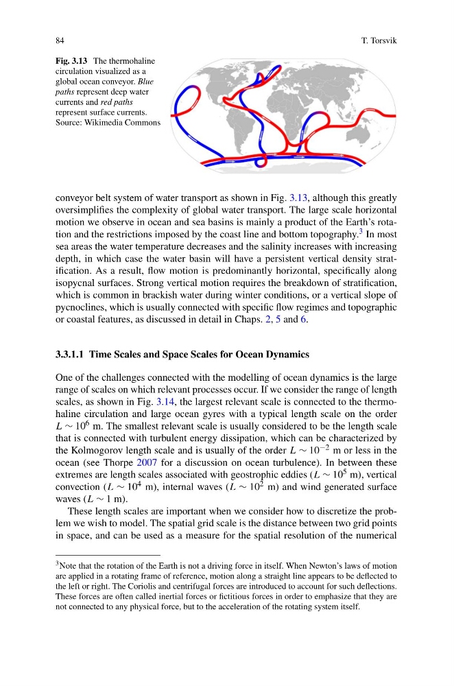
Fig. 3.13 The thermohaline
circulation visualized as a
global ocean conveyor. Blue
paths represent deep water
currents and red paths
represent surface currents.
Source: Wikimedia Commons
conveyor belt system of water transport as shown in Fig. 3.13, although this greatly
oversimplifies the complexity of global water transport. The large scale horizontal
motion we observe in ocean and sea basins is mainly a product of the Earth’s rotation and the restrictions imposed by the coast line and bottom topography. 3 In most
sea areas the water temperature decreases and the salinity increases with increasing
depth, in which case the water basin will have a persistent vertical density stratification. As a result, flow motion is predominantly horizontal, specifically along
isopycnal surfaces. Strong vertical motion requires the breakdown of stratification,
which is common in brackish water during winter conditions, or a vertical slope of
pycnoclines, which is usually connected with specific flow regimes and topographic
or coastal features, as discussed in detail in Chaps. 2, 5 and 6.
3.3.1.1 Time Scales and Space Scales for Ocean Dynamics
One of the challenges connected with the modelling of ocean dynamics is the large
range of scales on which relevant processes occur. If we consider the range of length
scales, as shown in Fig. 3.14, the largest relevant scale is connected to the thermohaline circulation and large ocean gyres with a typical length scale on the order
L ∼ 10 6 m. The smallest relevant scale is usually considered to be the length scale
that is connected with turbulent energy dissipation, which can be characterized by
the Kolmogorov length scale and is usually of the order L ∼ 10 −2 m or less in the
ocean (see Thorpe 2007 for a discussion on ocean turbulence). In between these
extremes are length scales associated with geostrophic eddies (L ∼ 10 5 m), vertical
convection (L ∼ 10 4 m), internal waves (L ∼ 10 2 m) and wind generated surface
waves (L ∼ 1 m).
These length scales are important when we consider how to discretize the problem we wish to model. The spatial grid scale is the distance between two grid points
in space, and can be used as a measure for the spatial resolution of the numerical
3 Note that the rotation of the Earth is not a driving force in itself. When Newton’s laws of motion
are applied in a rotating frame of reference, motion along a straight line appears to be deflected to
the left or right. The Coriolis and centrifugal forces are introduced to account for such deflections.
These forces are often called inertial forces or fictitious forces in order to emphasize that they are
not connected to any physical force, but to the acceleration of the rotating system itself.
T. Torsvik
Fig. 3.13 The thermohaline
circulation visualized as a
global ocean conveyor. Blue
paths represent deep water
currents and red paths
represent surface currents.
Source: Wikimedia Commons
conveyor belt system of water transport as shown in Fig. 3.13, although this greatly
oversimplifies the complexity of global water transport. The large scale horizontal
motion we observe in ocean and sea basins is mainly a product of the Earth’s rotation and the restrictions imposed by the coast line and bottom topography. 3 In most
sea areas the water temperature decreases and the salinity increases with increasing
depth, in which case the water basin will have a persistent vertical density stratification. As a result, flow motion is predominantly horizontal, specifically along
isopycnal surfaces. Strong vertical motion requires the breakdown of stratification,
which is common in brackish water during winter conditions, or a vertical slope of
pycnoclines, which is usually connected with specific flow regimes and topographic
or coastal features, as discussed in detail in Chaps. 2, 5 and 6.
3.3.1.1 Time Scales and Space Scales for Ocean Dynamics
One of the challenges connected with the modelling of ocean dynamics is the large
range of scales on which relevant processes occur. If we consider the range of length
scales, as shown in Fig. 3.14, the largest relevant scale is connected to the thermohaline circulation and large ocean gyres with a typical length scale on the order
L ∼ 10 6 m. The smallest relevant scale is usually considered to be the length scale
that is connected with turbulent energy dissipation, which can be characterized by
the Kolmogorov length scale and is usually of the order L ∼ 10 −2 m or less in the
ocean (see Thorpe 2007 for a discussion on ocean turbulence). In between these
extremes are length scales associated with geostrophic eddies (L ∼ 10 5 m), vertical
convection (L ∼ 10 4 m), internal waves (L ∼ 10 2 m) and wind generated surface
waves (L ∼ 1 m).
These length scales are important when we consider how to discretize the problem we wish to model. The spatial grid scale is the distance between two grid points
in space, and can be used as a measure for the spatial resolution of the numerical
3 Note that the rotation of the Earth is not a driving force in itself. When Newton’s laws of motion
are applied in a rotating frame of reference, motion along a straight line appears to be deflected to
the left or right. The Coriolis and centrifugal forces are introduced to account for such deflections.
These forces are often called inertial forces or fictitious forces in order to emphasize that they are
not connected to any physical force, but to the acceleration of the rotating system itself.