

32
K. Myrberg and A. Lehmann
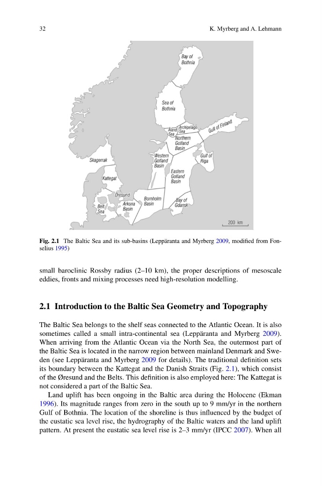
Fig. 2.1 The Baltic Sea and its sub-basins (Leppäranta and Myrberg 2009, modified from Fonselius 1995)
small baroclinic Rossby radius (2–10 km), the proper descriptions of mesoscale
eddies, fronts and mixing processes need high-resolution modelling.
2.1 Introduction to the Baltic Sea Geometry and Topography
The Baltic Sea belongs to the shelf seas connected to the Atlantic Ocean. It is also
sometimes called a small intra-continental sea (Leppäranta and Myrberg 2009).
When arriving from the Atlantic Ocean via the North Sea, the outermost part of
the Baltic Sea is located in the narrow region between mainland Denmark and Sweden (see Leppäranta and Myrberg 2009 for details). The traditional definition sets
its boundary between the Kattegat and the Danish Straits (Fig. 2.1), which consist
of the Øresund and the Belts. This definition is also employed here: The Kattegat is
not considered a part of the Baltic Sea.
Land uplift has been ongoing in the Baltic area during the Holocene (Ekman
1996). Its magnitude ranges from zero in the south up to 9 mm/yr in the northern
Gulf of Bothnia. The location of the shoreline is thus influenced by the budget of
the eustatic sea level rise, the hydrography of the Baltic waters and the land uplift
pattern. At present the eustatic sea level rise is 2–3 mm/yr (IPCC 2007). When all
K. Myrberg and A. Lehmann
Fig. 2.1 The Baltic Sea and its sub-basins (Leppäranta and Myrberg 2009, modified from Fonselius 1995)
small baroclinic Rossby radius (2–10 km), the proper descriptions of mesoscale
eddies, fronts and mixing processes need high-resolution modelling.
2.1 Introduction to the Baltic Sea Geometry and Topography
The Baltic Sea belongs to the shelf seas connected to the Atlantic Ocean. It is also
sometimes called a small intra-continental sea (Leppäranta and Myrberg 2009).
When arriving from the Atlantic Ocean via the North Sea, the outermost part of
the Baltic Sea is located in the narrow region between mainland Denmark and Sweden (see Leppäranta and Myrberg 2009 for details). The traditional definition sets
its boundary between the Kattegat and the Danish Straits (Fig. 2.1), which consist
of the Øresund and the Belts. This definition is also employed here: The Kattegat is
not considered a part of the Baltic Sea.
Land uplift has been ongoing in the Baltic area during the Holocene (Ekman
1996). Its magnitude ranges from zero in the south up to 9 mm/yr in the northern
Gulf of Bothnia. The location of the shoreline is thus influenced by the budget of
the eustatic sea level rise, the hydrography of the Baltic waters and the land uplift
pattern. At present the eustatic sea level rise is 2–3 mm/yr (IPCC 2007). When all