

10 Applications of the Inverse Problem of Pollution Propagation
355
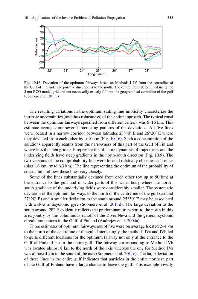
Fig. 10.16 Deviation of the optimum fairways based on Methods I–IV from the centreline of
the Gulf of Finland. The positive direction is to the north. The centreline is determined using the
2 nm RCO model grid and not necessarily exactly follows the geographical centreline of the gulf
(Soomere et al. 2011c)
The resulting variations in the optimum sailing line implicitly characterize the
intrinsic uncertainties (and thus robustness) of the entire approach. The typical rmsd
between the optimum fairways specified from different criteria was 6–16 km. This
estimate averages out several interesting patterns of the deviations. All five lines
were located in a narrow corridor between latitudes 23 ◦ 40 E and 26 ◦ 20 E where
they deviated from each other by <10 km (Fig. 10.16). Such a concentration of the
solutions apparently results from the narrowness of this part of the Gulf of Finland
where less than ten grid cells represent the offshore dynamics of trajectories and the
underlying fields have steep gradients in the north-south direction (Fig. 10.9). The
two versions of the equiprobability line were located relatively close to each other
(bias 1.6 km, rmsd 6.3 km). The line representing the optimum of the probability of
coastal hits follows these lines very closely.
Some of the lines substantially deviated from each other (by up to 50 km) at
the entrance to the gulf and in wider parts of this water body where the north–
south gradients of the underlying fields were considerably smaller. The systematic
deviation of the optimum fairways to the north of the centreline of the gulf (around
27 ◦ 20 E) and a smaller deviation to the south around 25 ◦ 30 E may be associated
with a slow anticyclonic gyre (Soomere et al. 2011d). The large deviation to the
south around 28 ◦ E evidently reflects the predominant transport to the north in this
area jointly by the voluminous runoff of the River Neva and the general cyclonic
circulation pattern in the Gulf of Finland (Andrejev et al. 2004a).
Three estimates of optimum fairways out of five were on average located 2–4 km
to the north of the centreline of the gulf. Interestingly, the methods IVa and IVb led
to quite different locations for the optimum fairway not only at the entrance to the
Gulf of Finland but in the entire gulf. The fairway corresponding to Method IVb
was located almost 8 km to the north of the axis whereas the one for Method IVa
was almost 4 km to the south of the axis (Soomere et al. 2011c). The large deviation
of these lines in the entire gulf indicates that particles in the entire northern part
of the Gulf of Finland have a large chance to leave the gulf. This example vividly
355
Fig. 10.16 Deviation of the optimum fairways based on Methods I–IV from the centreline of
the Gulf of Finland. The positive direction is to the north. The centreline is determined using the
2 nm RCO model grid and not necessarily exactly follows the geographical centreline of the gulf
(Soomere et al. 2011c)
The resulting variations in the optimum sailing line implicitly characterize the
intrinsic uncertainties (and thus robustness) of the entire approach. The typical rmsd
between the optimum fairways specified from different criteria was 6–16 km. This
estimate averages out several interesting patterns of the deviations. All five lines
were located in a narrow corridor between latitudes 23 ◦ 40 E and 26 ◦ 20 E where
they deviated from each other by <10 km (Fig. 10.16). Such a concentration of the
solutions apparently results from the narrowness of this part of the Gulf of Finland
where less than ten grid cells represent the offshore dynamics of trajectories and the
underlying fields have steep gradients in the north-south direction (Fig. 10.9). The
two versions of the equiprobability line were located relatively close to each other
(bias 1.6 km, rmsd 6.3 km). The line representing the optimum of the probability of
coastal hits follows these lines very closely.
Some of the lines substantially deviated from each other (by up to 50 km) at
the entrance to the gulf and in wider parts of this water body where the north–
south gradients of the underlying fields were considerably smaller. The systematic
deviation of the optimum fairways to the north of the centreline of the gulf (around
27 ◦ 20 E) and a smaller deviation to the south around 25 ◦ 30 E may be associated
with a slow anticyclonic gyre (Soomere et al. 2011d). The large deviation to the
south around 28 ◦ E evidently reflects the predominant transport to the north in this
area jointly by the voluminous runoff of the River Neva and the general cyclonic
circulation pattern in the Gulf of Finland (Andrejev et al. 2004a).
Three estimates of optimum fairways out of five were on average located 2–4 km
to the north of the centreline of the gulf. Interestingly, the methods IVa and IVb led
to quite different locations for the optimum fairway not only at the entrance to the
Gulf of Finland but in the entire gulf. The fairway corresponding to Method IVb
was located almost 8 km to the north of the axis whereas the one for Method IVa
was almost 4 km to the south of the axis (Soomere et al. 2011c). The large deviation
of these lines in the entire gulf indicates that particles in the entire northern part
of the Gulf of Finland have a large chance to leave the gulf. This example vividly