

254
J. Kjellsson et al.
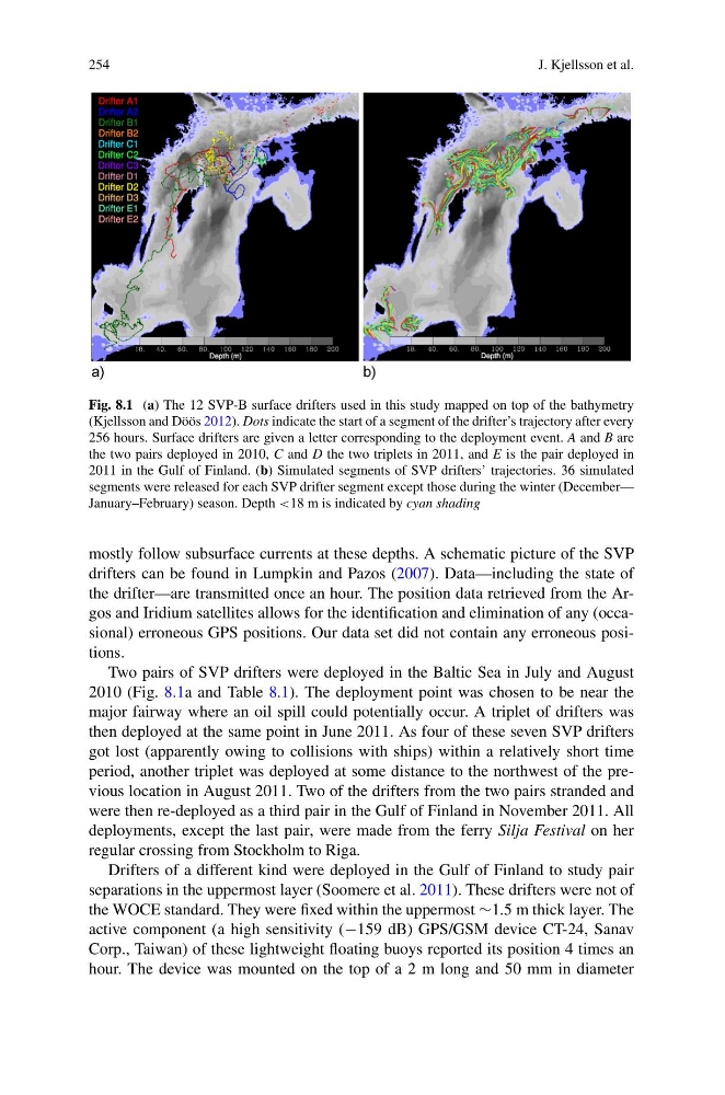
Fig. 8.1 (a) The 12 SVP-B surface drifters used in this study mapped on top of the bathymetry
(Kjellsson and Döös 2012). Dots indicate the start of a segment of the drifter’s trajectory after every
256 hours. Surface drifters are given a letter corresponding to the deployment event. A and B are
the two pairs deployed in 2010, C and D the two triplets in 2011, and E is the pair deployed in
2011 in the Gulf of Finland. (b) Simulated segments of SVP drifters’ trajectories. 36 simulated
segments were released for each SVP drifter segment except those during the winter (December—
January–February) season. Depth <18 m is indicated by cyan shading
mostly follow subsurface currents at these depths. A schematic picture of the SVP
drifters can be found in Lumpkin and Pazos (2007). Data—including the state of
the drifter—are transmitted once an hour. The position data retrieved from the Argos and Iridium satellites allows for the identification and elimination of any (occasional) erroneous GPS positions. Our data set did not contain any erroneous positions.
Two pairs of SVP drifters were deployed in the Baltic Sea in July and August
2010 (Fig. 8.1a and Table 8.1). The deployment point was chosen to be near the
major fairway where an oil spill could potentially occur. A triplet of drifters was
then deployed at the same point in June 2011. As four of these seven SVP drifters
got lost (apparently owing to collisions with ships) within a relatively short time
period, another triplet was deployed at some distance to the northwest of the previous location in August 2011. Two of the drifters from the two pairs stranded and
were then re-deployed as a third pair in the Gulf of Finland in November 2011. All
deployments, except the last pair, were made from the ferry Silja Festival on her
regular crossing from Stockholm to Riga.
Drifters of a different kind were deployed in the Gulf of Finland to study pair
separations in the uppermost layer (Soomere et al. 2011). These drifters were not of
the WOCE standard. They were fixed within the uppermost ∼1.5 m thick layer. The
active component (a high sensitivity (−159 dB) GPS/GSM device CT-24, Sanav
Corp., Taiwan) of these lightweight floating buoys reported its position 4 times an
hour. The device was mounted on the top of a 2 m long and 50 mm in diameter
J. Kjellsson et al.
Fig. 8.1 (a) The 12 SVP-B surface drifters used in this study mapped on top of the bathymetry
(Kjellsson and Döös 2012). Dots indicate the start of a segment of the drifter’s trajectory after every
256 hours. Surface drifters are given a letter corresponding to the deployment event. A and B are
the two pairs deployed in 2010, C and D the two triplets in 2011, and E is the pair deployed in
2011 in the Gulf of Finland. (b) Simulated segments of SVP drifters’ trajectories. 36 simulated
segments were released for each SVP drifter segment except those during the winter (December—
January–February) season. Depth <18 m is indicated by cyan shading
mostly follow subsurface currents at these depths. A schematic picture of the SVP
drifters can be found in Lumpkin and Pazos (2007). Data—including the state of
the drifter—are transmitted once an hour. The position data retrieved from the Argos and Iridium satellites allows for the identification and elimination of any (occasional) erroneous GPS positions. Our data set did not contain any erroneous positions.
Two pairs of SVP drifters were deployed in the Baltic Sea in July and August
2010 (Fig. 8.1a and Table 8.1). The deployment point was chosen to be near the
major fairway where an oil spill could potentially occur. A triplet of drifters was
then deployed at the same point in June 2011. As four of these seven SVP drifters
got lost (apparently owing to collisions with ships) within a relatively short time
period, another triplet was deployed at some distance to the northwest of the previous location in August 2011. Two of the drifters from the two pairs stranded and
were then re-deployed as a third pair in the Gulf of Finland in November 2011. All
deployments, except the last pair, were made from the ferry Silja Festival on her
regular crossing from Stockholm to Riga.
Drifters of a different kind were deployed in the Gulf of Finland to study pair
separations in the uppermost layer (Soomere et al. 2011). These drifters were not of
the WOCE standard. They were fixed within the uppermost ∼1.5 m thick layer. The
active component (a high sensitivity (−159 dB) GPS/GSM device CT-24, Sanav
Corp., Taiwan) of these lightweight floating buoys reported its position 4 times an
hour. The device was mounted on the top of a 2 m long and 50 mm in diameter