

6 The Gulf of Finland
209
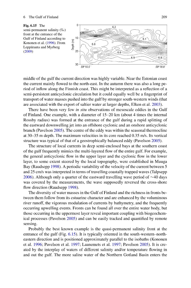
Fig. 6.15 The
semi-permanent salinity (‰)
front at the entrance of the
Gulf of Finland according to
Kononen et al. (1996). From
Leppäranta and Myrberg
(2009)
middle of the gulf the current direction was highly variable. Near the Estonian coast
the current mainly flowed to the north-east. In the autumn there was also a long period of inflow along the Finnish coast. This might be interpreted as a reflection of a
semi-persistent anticyclonic circulation but it could equally well be a fingerprint of
transport of water masses pushed into the gulf by stronger south-western winds (that
are associated with the export of saltier water at larger depths, Elken et al. 2003).
There have been very few in situ observations of mesoscale eddies in the Gulf
of Finland. One example, with a diameter of 15–20 km (about 4 times the internal
Rossby radius) was formed at the entrance of the gulf during a rapid splitting of
the eastward downwelling jet into an offshore cyclonic and an onshore anticyclonic
branch (Pavelson 2005). The centre of the eddy was within the seasonal thermocline
at 30–35 m depth. The maximum velocities in its core reached 0.35 m/s. Its vertical
structure was typical of that of a geostrophically balanced eddy (Pavelson 2005).
The structure of local currents in deep semi-enclosed bays at the southern coast
of the gulf frequently mimics the multi-layered flow of the entire gulf. For example,
the general anticyclonic flow in the upper layer and the cyclonic flow in the lower
layer, to some extent steered by the local topography, were established in Muuga
Bay (Raudsepp 1998). A periodic variability of the velocity of the current between 5
and 25 cm/s was interpreted in terms of travelling coastally trapped waves (Talpsepp
2006). Although only a quarter of the eastward travelling wave period of ∼40 days
was covered by the measurements, the wave supposedly reversed the cross-shore
flow direction (Raudsepp 1998).
The diversity of water masses in the Gulf of Finland and the richness in fronts between them follow from its estuarine character and are enhanced by the voluminous
river runoff, the vigorous modulation of currents by bathymetry, and the frequently
occurring upwelling events. Fronts can be found all over the entire water body, but
those occurring in the uppermost layer reveal important coupling with biogeochemical processes (Pavelson 2005) and can be easily tracked and quantified by remote
sensing.
Probably the best known example is the quasi-permanent salinity front at the
entrance of the gulf (Fig. 6.15). It is typically oriented in the south-western–northeastern direction and is positioned approximately parallel to the isobaths (Kononen
et al. 1996; Pavelson et al. 1997; Laanemets et al. 1997; Pavelson 2005). It is created by the interplay of waters of different salinity and/or temperature flowing in
and out the gulf. The more saline water of the Northern Gotland Basin enters the
209
Fig. 6.15 The
semi-permanent salinity (‰)
front at the entrance of the
Gulf of Finland according to
Kononen et al. (1996). From
Leppäranta and Myrberg
(2009)
middle of the gulf the current direction was highly variable. Near the Estonian coast
the current mainly flowed to the north-east. In the autumn there was also a long period of inflow along the Finnish coast. This might be interpreted as a reflection of a
semi-persistent anticyclonic circulation but it could equally well be a fingerprint of
transport of water masses pushed into the gulf by stronger south-western winds (that
are associated with the export of saltier water at larger depths, Elken et al. 2003).
There have been very few in situ observations of mesoscale eddies in the Gulf
of Finland. One example, with a diameter of 15–20 km (about 4 times the internal
Rossby radius) was formed at the entrance of the gulf during a rapid splitting of
the eastward downwelling jet into an offshore cyclonic and an onshore anticyclonic
branch (Pavelson 2005). The centre of the eddy was within the seasonal thermocline
at 30–35 m depth. The maximum velocities in its core reached 0.35 m/s. Its vertical
structure was typical of that of a geostrophically balanced eddy (Pavelson 2005).
The structure of local currents in deep semi-enclosed bays at the southern coast
of the gulf frequently mimics the multi-layered flow of the entire gulf. For example,
the general anticyclonic flow in the upper layer and the cyclonic flow in the lower
layer, to some extent steered by the local topography, were established in Muuga
Bay (Raudsepp 1998). A periodic variability of the velocity of the current between 5
and 25 cm/s was interpreted in terms of travelling coastally trapped waves (Talpsepp
2006). Although only a quarter of the eastward travelling wave period of ∼40 days
was covered by the measurements, the wave supposedly reversed the cross-shore
flow direction (Raudsepp 1998).
The diversity of water masses in the Gulf of Finland and the richness in fronts between them follow from its estuarine character and are enhanced by the voluminous
river runoff, the vigorous modulation of currents by bathymetry, and the frequently
occurring upwelling events. Fronts can be found all over the entire water body, but
those occurring in the uppermost layer reveal important coupling with biogeochemical processes (Pavelson 2005) and can be easily tracked and quantified by remote
sensing.
Probably the best known example is the quasi-permanent salinity front at the
entrance of the gulf (Fig. 6.15). It is typically oriented in the south-western–northeastern direction and is positioned approximately parallel to the isobaths (Kononen
et al. 1996; Pavelson et al. 1997; Laanemets et al. 1997; Pavelson 2005). It is created by the interplay of waters of different salinity and/or temperature flowing in
and out the gulf. The more saline water of the Northern Gotland Basin enters the