

186
K. Myrberg and T. Soomere
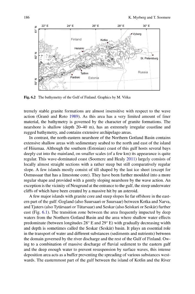
Fig. 6.2 The bathymetry of the Gulf of Finland. Graphics by M. Viška
tremely stable granite formations are almost insensitive with respect to the wave
action (Granö and Roto 1989). As this area has a very limited amount of finer
material, the bathymetry is governed by the character of granite formations. The
nearshore is shallow (depth 20–40 m), has an extremely irregular coastline and
rugged bathymetry, and contains extensive archipelago areas.
In contrast, the north-eastern nearshore of the Northern Gotland Basin contains
extensive shallow areas with sedimentary seabed to the north and east of the island
of Hiiumaa. Although the southern (Estonian) coast of this gulf hosts several bays
deeply cut into the mainland, on smaller scales (of a few km) its appearance is quite
regular. This wave-dominated coast (Soomere and Healy 2011) largely consists of
locally almost straight sections with a rather steep but still comparatively regular
slope. A few islands mostly consist of till shaped by the last ice sheet (except for
Osmussaar that has a limestone core). They have been further moulded into a more
regular shape and provided with a gently sloping nearshore by the wave action. An
exception is the vicinity of Neugrund at the entrance to the gulf, the steep underwater
cliffs of which have been created by a massive hit by an asteroid.
A few major islands with granite core and steep slopes lie far offshore in the eastern part of the gulf: Gogland (also Suursaari or Suursaar) between Kotka and Narva,
and Tjuters (also Tytärsaari or Tütarsaar) and Seskar (also Seiskari or Seskär) further
east (Fig. 6.1). The transition zone between the area frequently impacted by deep
waters from the Northern Gotland Basin and the area where shallow water effects
predominate (between longitudes 28° E and 29° E) with gradually decreasing width
and depth is sometimes called the Seskar (Seskär) basin. It plays an essential role
in the transport of water and different substances (sediments and nutrients) between
the domain governed by the river discharge and the rest of the Gulf of Finland. Owing to a combination of massive discharge of fluvial sediment to the eastern gulf
and the deep enough water to prevent resuspension by surface waves, this intense
deposition area acts as a buffer preventing the spreading of various substances westwards. The easternmost part of the gulf between the island of Kotlin and the River
K. Myrberg and T. Soomere
Fig. 6.2 The bathymetry of the Gulf of Finland. Graphics by M. Viška
tremely stable granite formations are almost insensitive with respect to the wave
action (Granö and Roto 1989). As this area has a very limited amount of finer
material, the bathymetry is governed by the character of granite formations. The
nearshore is shallow (depth 20–40 m), has an extremely irregular coastline and
rugged bathymetry, and contains extensive archipelago areas.
In contrast, the north-eastern nearshore of the Northern Gotland Basin contains
extensive shallow areas with sedimentary seabed to the north and east of the island
of Hiiumaa. Although the southern (Estonian) coast of this gulf hosts several bays
deeply cut into the mainland, on smaller scales (of a few km) its appearance is quite
regular. This wave-dominated coast (Soomere and Healy 2011) largely consists of
locally almost straight sections with a rather steep but still comparatively regular
slope. A few islands mostly consist of till shaped by the last ice sheet (except for
Osmussaar that has a limestone core). They have been further moulded into a more
regular shape and provided with a gently sloping nearshore by the wave action. An
exception is the vicinity of Neugrund at the entrance to the gulf, the steep underwater
cliffs of which have been created by a massive hit by an asteroid.
A few major islands with granite core and steep slopes lie far offshore in the eastern part of the gulf: Gogland (also Suursaari or Suursaar) between Kotka and Narva,
and Tjuters (also Tytärsaari or Tütarsaar) and Seskar (also Seiskari or Seskär) further
east (Fig. 6.1). The transition zone between the area frequently impacted by deep
waters from the Northern Gotland Basin and the area where shallow water effects
predominate (between longitudes 28° E and 29° E) with gradually decreasing width
and depth is sometimes called the Seskar (Seskär) basin. It plays an essential role
in the transport of water and different substances (sediments and nutrients) between
the domain governed by the river discharge and the rest of the Gulf of Finland. Owing to a combination of massive discharge of fluvial sediment to the eastern gulf
and the deep enough water to prevent resuspension by surface waves, this intense
deposition area acts as a buffer preventing the spreading of various substances westwards. The easternmost part of the gulf between the island of Kotlin and the River