

102
H.E.M. Meier and A. Höglund
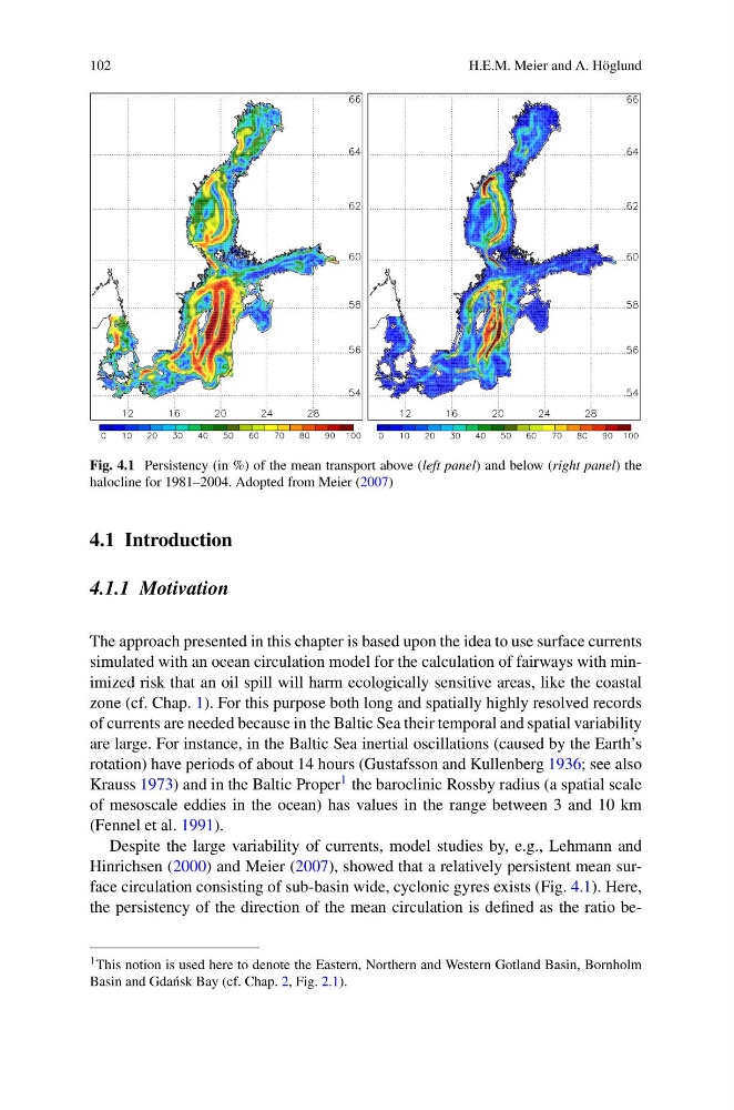
Fig. 4.1 Persistency (in %) of the mean transport above (left panel) and below (right panel) the
halocline for 1981–2004. Adopted from Meier (2007)
4.1 Introduction
4.1.1 Motivation
The approach presented in this chapter is based upon the idea to use surface currents
simulated with an ocean circulation model for the calculation of fairways with minimized risk that an oil spill will harm ecologically sensitive areas, like the coastal
zone (cf. Chap. 1). For this purpose both long and spatially highly resolved records
of currents are needed because in the Baltic Sea their temporal and spatial variability
are large. For instance, in the Baltic Sea inertial oscillations (caused by the Earth’s
rotation) have periods of about 14 hours (Gustafsson and Kullenberg 1936; see also
Krauss 1973) and in the Baltic Proper 1 the baroclinic Rossby radius (a spatial scale
of mesoscale eddies in the ocean) has values in the range between 3 and 10 km
(Fennel et al. 1991).
Despite the large variability of currents, model studies by, e.g., Lehmann and
Hinrichsen (2000) and Meier (2007), showed that a relatively persistent mean surface circulation consisting of sub-basin wide, cyclonic gyres exists (Fig. 4.1). Here,
the persistency of the direction of the mean circulation is defined as the ratio be1 This notion is used here to denote the Eastern, Northern and Western Gotland Basin, Bornholm
Basin and Gda´ nsk Bay (cf. Chap. 2, Fig. 2.1).
H.E.M. Meier and A. Höglund
Fig. 4.1 Persistency (in %) of the mean transport above (left panel) and below (right panel) the
halocline for 1981–2004. Adopted from Meier (2007)
4.1 Introduction
4.1.1 Motivation
The approach presented in this chapter is based upon the idea to use surface currents
simulated with an ocean circulation model for the calculation of fairways with minimized risk that an oil spill will harm ecologically sensitive areas, like the coastal
zone (cf. Chap. 1). For this purpose both long and spatially highly resolved records
of currents are needed because in the Baltic Sea their temporal and spatial variability
are large. For instance, in the Baltic Sea inertial oscillations (caused by the Earth’s
rotation) have periods of about 14 hours (Gustafsson and Kullenberg 1936; see also
Krauss 1973) and in the Baltic Proper 1 the baroclinic Rossby radius (a spatial scale
of mesoscale eddies in the ocean) has values in the range between 3 and 10 km
(Fennel et al. 1991).
Despite the large variability of currents, model studies by, e.g., Lehmann and
Hinrichsen (2000) and Meier (2007), showed that a relatively persistent mean surface circulation consisting of sub-basin wide, cyclonic gyres exists (Fig. 4.1). Here,
the persistency of the direction of the mean circulation is defined as the ratio be1 This notion is used here to denote the Eastern, Northern and Western Gotland Basin, Bornholm
Basin and Gda´ nsk Bay (cf. Chap. 2, Fig. 2.1).