

96
T. Torsvik
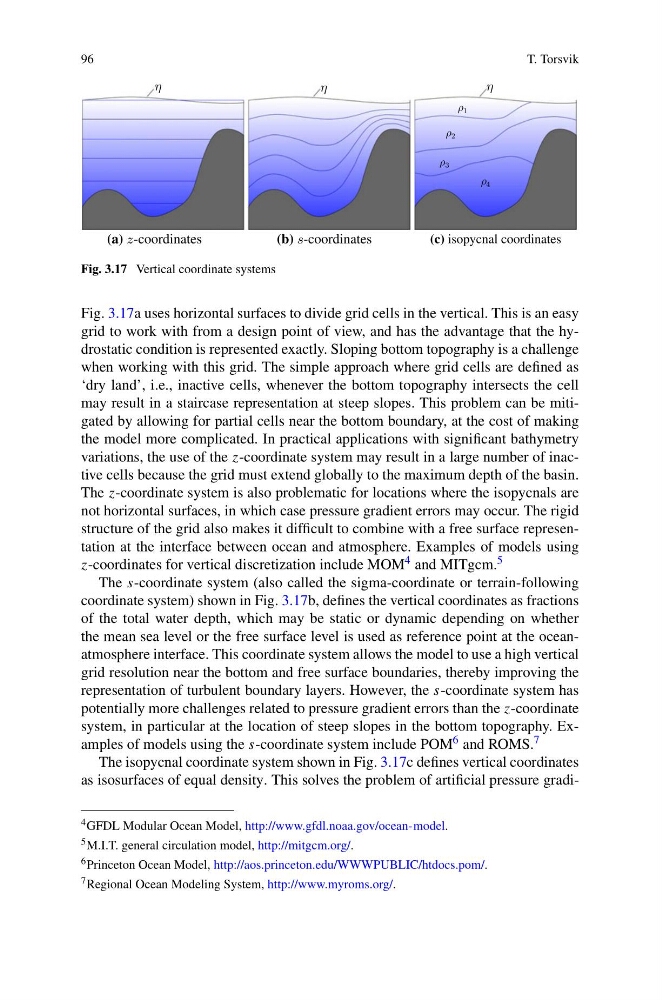
Fig. 3.17 Vertical coordinate systems
Fig. 3.17a uses horizontal surfaces to divide grid cells in the vertical. This is an easy
grid to work with from a design point of view, and has the advantage that the hydrostatic condition is represented exactly. Sloping bottom topography is a challenge
when working with this grid. The simple approach where grid cells are defined as
‘dry land’, i.e., inactive cells, whenever the bottom topography intersects the cell
may result in a staircase representation at steep slopes. This problem can be mitigated by allowing for partial cells near the bottom boundary, at the cost of making
the model more complicated. In practical applications with significant bathymetry
variations, the use of the z-coordinate system may result in a large number of inactive cells because the grid must extend globally to the maximum depth of the basin.
The z-coordinate system is also problematic for locations where the isopycnals are
not horizontal surfaces, in which case pressure gradient errors may occur. The rigid
structure of the grid also makes it difficult to combine with a free surface representation at the interface between ocean and atmosphere. Examples of models using
z-coordinates for vertical discretization include MOM 4 and MITgcm. 5
The s-coordinate system (also called the sigma-coordinate or terrain-following
coordinate system) shown in Fig. 3.17b, defines the vertical coordinates as fractions
of the total water depth, which may be static or dynamic depending on whether
the mean sea level or the free surface level is used as reference point at the oceanatmosphere interface. This coordinate system allows the model to use a high vertical
grid resolution near the bottom and free surface boundaries, thereby improving the
representation of turbulent boundary layers. However, the s-coordinate system has
potentially more challenges related to pressure gradient errors than the z-coordinate
system, in particular at the location of steep slopes in the bottom topography. Examples of models using the s-coordinate system include POM 6 and ROMS. 7
The isopycnal coordinate system shown in Fig. 3.17c defines vertical coordinates
as isosurfaces of equal density. This solves the problem of artificial pressure gradi4 GFDL Modular Ocean Model, http://www.gfdl.noaa.gov/ocean-model.
5 M.I.T. general circulation model, http://mitgcm.org/.
6 Princeton Ocean Model, http://aos.princeton.edu/WWWPUBLIC/htdocs.pom/.
7 Regional Ocean Modeling System, http://www.myroms.org/.
T. Torsvik
Fig. 3.17 Vertical coordinate systems
Fig. 3.17a uses horizontal surfaces to divide grid cells in the vertical. This is an easy
grid to work with from a design point of view, and has the advantage that the hydrostatic condition is represented exactly. Sloping bottom topography is a challenge
when working with this grid. The simple approach where grid cells are defined as
‘dry land’, i.e., inactive cells, whenever the bottom topography intersects the cell
may result in a staircase representation at steep slopes. This problem can be mitigated by allowing for partial cells near the bottom boundary, at the cost of making
the model more complicated. In practical applications with significant bathymetry
variations, the use of the z-coordinate system may result in a large number of inactive cells because the grid must extend globally to the maximum depth of the basin.
The z-coordinate system is also problematic for locations where the isopycnals are
not horizontal surfaces, in which case pressure gradient errors may occur. The rigid
structure of the grid also makes it difficult to combine with a free surface representation at the interface between ocean and atmosphere. Examples of models using
z-coordinates for vertical discretization include MOM 4 and MITgcm. 5
The s-coordinate system (also called the sigma-coordinate or terrain-following
coordinate system) shown in Fig. 3.17b, defines the vertical coordinates as fractions
of the total water depth, which may be static or dynamic depending on whether
the mean sea level or the free surface level is used as reference point at the oceanatmosphere interface. This coordinate system allows the model to use a high vertical
grid resolution near the bottom and free surface boundaries, thereby improving the
representation of turbulent boundary layers. However, the s-coordinate system has
potentially more challenges related to pressure gradient errors than the z-coordinate
system, in particular at the location of steep slopes in the bottom topography. Examples of models using the s-coordinate system include POM 6 and ROMS. 7
The isopycnal coordinate system shown in Fig. 3.17c defines vertical coordinates
as isosurfaces of equal density. This solves the problem of artificial pressure gradi4 GFDL Modular Ocean Model, http://www.gfdl.noaa.gov/ocean-model.
5 M.I.T. general circulation model, http://mitgcm.org/.
6 Princeton Ocean Model, http://aos.princeton.edu/WWWPUBLIC/htdocs.pom/.
7 Regional Ocean Modeling System, http://www.myroms.org/.