

objectives of restoring the dune to a more natural shape, and carrying out some
dune re-vegetation utilizing native species, along a 150-m length of the dune.
5.3.1 Foredune Reshaping
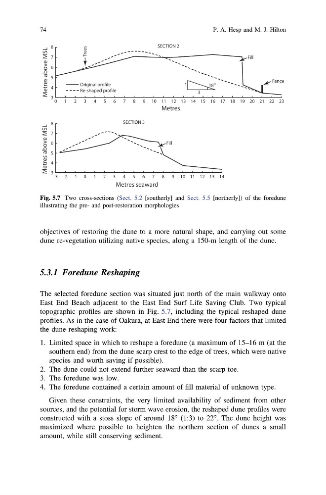
The selected foredune section was situated just north of the main walkway onto
East End Beach adjacent to the East End Surf Life Saving Club. Two typical
topographic profiles are shown in Fig. 5.7, including the typical reshaped dune
profiles. As in the case of Oakura, at East End there were four factors that limited
the dune reshaping work:
1. Limited space in which to reshape a foredune (a maximum of 15–16 m (at the
southern end) from the dune scarp crest to the edge of trees, which were native
species and worth saving if possible).
2. The dune could not extend further seaward than the scarp toe.
3. The foredune was low.
4. The foredune contained a certain amount of fill material of unknown type.
Given these constraints, the very limited availability of sediment from other
sources, and the potential for storm wave erosion, the reshaped dune profiles were
constructed with a stoss slope of around 18° (1:3) to 22°. The dune height was
maximized where possible to heighten the northern section of dunes a small
amount, while still conserving sediment.
Fig. 5.7 Two cross-sections (Sect. 5.2 [southerly] and Sect. 5.5 [northerly]) of the foredune
illustrating the pre- and post-restoration morphologies
74
P. A. Hesp and M. J. Hilton
dune re-vegetation utilizing native species, along a 150-m length of the dune.
5.3.1 Foredune Reshaping
The selected foredune section was situated just north of the main walkway onto
East End Beach adjacent to the East End Surf Life Saving Club. Two typical
topographic profiles are shown in Fig. 5.7, including the typical reshaped dune
profiles. As in the case of Oakura, at East End there were four factors that limited
the dune reshaping work:
1. Limited space in which to reshape a foredune (a maximum of 15–16 m (at the
southern end) from the dune scarp crest to the edge of trees, which were native
species and worth saving if possible).
2. The dune could not extend further seaward than the scarp toe.
3. The foredune was low.
4. The foredune contained a certain amount of fill material of unknown type.
Given these constraints, the very limited availability of sediment from other
sources, and the potential for storm wave erosion, the reshaped dune profiles were
constructed with a stoss slope of around 18° (1:3) to 22°. The dune height was
maximized where possible to heighten the northern section of dunes a small
amount, while still conserving sediment.
Fig. 5.7 Two cross-sections (Sect. 5.2 [southerly] and Sect. 5.5 [northerly]) of the foredune
illustrating the pre- and post-restoration morphologies
74
P. A. Hesp and M. J. Hilton