

5.2 Delineation of the Development in Northern Germany
75
Single Value
Procedure
Composion
Procedure
1 m
2 m
3 m
4 m
5 m
6 m
7 m
8 m
NN 0,00 m
Thw
MThw
HSp Thw (max)
HHThw
Design water level
Crest height
HHThw
Composion water
level
Crest height
a
b
c
d
e
a1
c
e
*
9 m
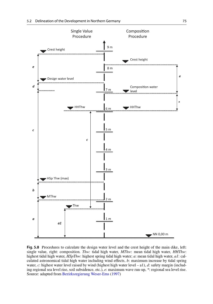
Fig. 5.8 Procedures to calculate the design water level and the crest height of the main dike, left:
single value, right: composition. Thw: tidal high water, MThw: mean tidal high water, HHThw:
highest tidal high water, HSpThw: highest spring tidal high water; a: mean tidal high water, a1: calculated astronomical tidal high water including wind effects, b: maximum increase by tidal spring
water, c: highest water level raised by wind (highest high water level – a1), d: safety margin (including regional sea level rise, soil subsidence, etc.), e: maximum wave run-up, *: regional sea level rise.
Source: adapted from Bezirksregierung Weser-Ems (1997)
75
Single Value
Procedure
Composion
Procedure
1 m
2 m
3 m
4 m
5 m
6 m
7 m
8 m
NN 0,00 m
Thw
MThw
HSp Thw (max)
HHThw
Design water level
Crest height
HHThw
Composion water
level
Crest height
a
b
c
d
e
a1
c
e
*
9 m
Fig. 5.8 Procedures to calculate the design water level and the crest height of the main dike, left:
single value, right: composition. Thw: tidal high water, MThw: mean tidal high water, HHThw:
highest tidal high water, HSpThw: highest spring tidal high water; a: mean tidal high water, a1: calculated astronomical tidal high water including wind effects, b: maximum increase by tidal spring
water, c: highest water level raised by wind (highest high water level – a1), d: safety margin (including regional sea level rise, soil subsidence, etc.), e: maximum wave run-up, *: regional sea level rise.
Source: adapted from Bezirksregierung Weser-Ems (1997)