

5.1 Coastal Protection Management
67
Denmark
Germany
Netherlands
Belgium
United
Kingdom
Round off
totals
Total coastline
length a
Developed 1 km
coastal strip
b
Area below +5
m sea level
c
Populaon
below mean
sea level
d
4,605 km
9%
1,500 km 2
< 5,000
3,524 km
11%
9,000 km 2
1,800,000
1,276 km
12%
19,000 km 2
9,000,000
98 km
48%
2,500 km 2
380,000
17,381 km
-
6,500 km 2
2,500,000
~27,000 km
-
~38,000 km 2
~14 Million
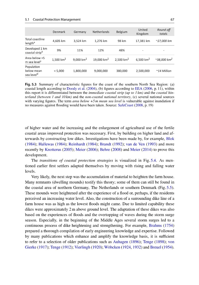
Fig. 5.3 Summary of characteristic figures for the coast of the southern North Sea Region: (a)
coastal length according to Doody et al. (2004), (b) figures according to EEA (2006, p. 11), within
this report it is differentiated between the immediate coastal strip (up to 1 km) and the coastal hinterland (between 1 and 10 km) and the non-coastal national territory, (c) several national sources
with varying figures. The term area below +5 m mean sea level is vulnerable against inundation if
no measures against flooding would have been taken. Source: SafeCoast (2008, p. 19)
of higher water and the increasing and the enlargement of agricultural use of the fertile
coastal areas improved protection was necessary. First, by building on higher land and afterwards by constructing low dikes. Investigations have been made by, for example, Blok
(1984); Hallewas (1984); Reinhardt (1984); Brandt (1992); van de Ven (1993) and more
recently by Knotterus (2005); Meier (2006); Behre (2008) and Meier (2014) to prove this
development.
The transitions of coastal protection strategies is visualized in Fig. 5.4. As mentioned earlier first settlers adapted themselves by moving with rising and falling water
levels.
Very likely, the next step was the accumulation of material to heighten the farm house.
Many remnants (dwelling mounds) testify this theory; some of them can still be found in
the coastal area of northern Germany, The Netherlands or southern Denmark (Fig. 5.5).
These mounds were heightened after the experience of a flood or, perhaps, if the residents
perceived an increasing water level. Also, the construction of a surrounding dike line of a
farm house was as high as the lowest floods might came. Due to limited capability these
dikes were approximately 2 m above ground level. The adaptation of these dikes was also
based on the experiences of floods and the overtopping of waves during the storm surge
season. Especially, in the beginning of the Middle Ages several storm surges led to a
continuous process of dike heightening and strengthening. For example, Brahms (1754)
prepared a thorough compilation of early engineering knowledge and expertise. Followed
by many publications which enhance and amplify the knowledge basis, it is sufficient
to refer to a selection of older publications such as Auhagen (1896); Tenge (1898); von
Gierke (1917); Tenge (1912); Vierlingh (1920); Wöbcken (1924, 1932) and Breuel (1954).
67
Denmark
Germany
Netherlands
Belgium
United
Kingdom
Round off
totals
Total coastline
length a
Developed 1 km
coastal strip
b
Area below +5
m sea level
c
Populaon
below mean
sea level
d
4,605 km
9%
1,500 km 2
< 5,000
3,524 km
11%
9,000 km 2
1,800,000
1,276 km
12%
19,000 km 2
9,000,000
98 km
48%
2,500 km 2
380,000
17,381 km
-
6,500 km 2
2,500,000
~27,000 km
-
~38,000 km 2
~14 Million
Fig. 5.3 Summary of characteristic figures for the coast of the southern North Sea Region: (a)
coastal length according to Doody et al. (2004), (b) figures according to EEA (2006, p. 11), within
this report it is differentiated between the immediate coastal strip (up to 1 km) and the coastal hinterland (between 1 and 10 km) and the non-coastal national territory, (c) several national sources
with varying figures. The term area below +5 m mean sea level is vulnerable against inundation if
no measures against flooding would have been taken. Source: SafeCoast (2008, p. 19)
of higher water and the increasing and the enlargement of agricultural use of the fertile
coastal areas improved protection was necessary. First, by building on higher land and afterwards by constructing low dikes. Investigations have been made by, for example, Blok
(1984); Hallewas (1984); Reinhardt (1984); Brandt (1992); van de Ven (1993) and more
recently by Knotterus (2005); Meier (2006); Behre (2008) and Meier (2014) to prove this
development.
The transitions of coastal protection strategies is visualized in Fig. 5.4. As mentioned earlier first settlers adapted themselves by moving with rising and falling water
levels.
Very likely, the next step was the accumulation of material to heighten the farm house.
Many remnants (dwelling mounds) testify this theory; some of them can still be found in
the coastal area of northern Germany, The Netherlands or southern Denmark (Fig. 5.5).
These mounds were heightened after the experience of a flood or, perhaps, if the residents
perceived an increasing water level. Also, the construction of a surrounding dike line of a
farm house was as high as the lowest floods might came. Due to limited capability these
dikes were approximately 2 m above ground level. The adaptation of these dikes was also
based on the experiences of floods and the overtopping of waves during the storm surge
season. Especially, in the beginning of the Middle Ages several storm surges led to a
continuous process of dike heightening and strengthening. For example, Brahms (1754)
prepared a thorough compilation of early engineering knowledge and expertise. Followed
by many publications which enhance and amplify the knowledge basis, it is sufficient
to refer to a selection of older publications such as Auhagen (1896); Tenge (1898); von
Gierke (1917); Tenge (1912); Vierlingh (1920); Wöbcken (1924, 1932) and Breuel (1954).