

5.4 Estuaries in the Southern North Sea Region
105
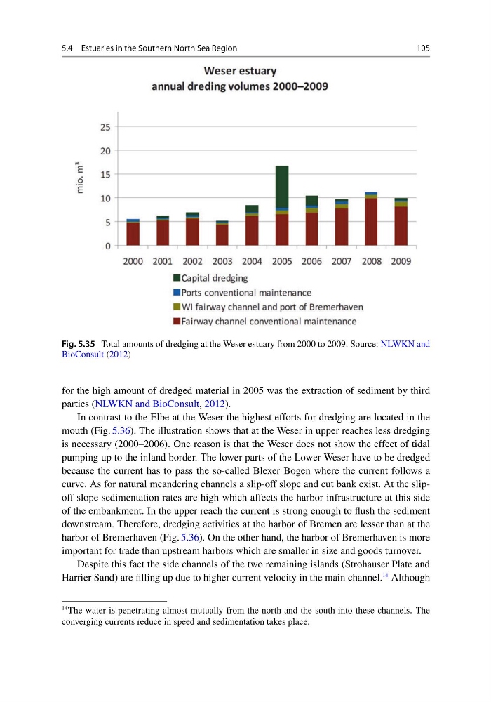
Fig. 5.35 Total amounts of dredging at the Weser estuary from 2000 to 2009. Source: NLWKN and
BioConsult (2012)
for the high amount of dredged material in 2005 was the extraction of sediment by third
parties (NLWKN and BioConsult, 2012).
In contrast to the Elbe at the Weser the highest efforts for dredging are located in the
mouth (Fig. 5.36). The illustration shows that at the Weser in upper reaches less dredging
is necessary (2000–2006). One reason is that the Weser does not show the effect of tidal
pumping up to the inland border. The lower parts of the Lower Weser have to be dredged
because the current has to pass the so-called Blexer Bogen where the current follows a
curve. As for natural meandering channels a slip-off slope and cut bank exist. At the slipoff slope sedimentation rates are high which affects the harbor infrastructure at this side
of the embankment. In the upper reach the current is strong enough to flush the sediment
downstream. Therefore, dredging activities at the harbor of Bremen are lesser than at the
harbor of Bremerhaven (Fig. 5.36). On the other hand, the harbor of Bremerhaven is more
important for trade than upstream harbors which are smaller in size and goods turnover.
Despite this fact the side channels of the two remaining islands (Strohauser Plate and
Harrier Sand) are filling up due to higher current velocity in the main channel.
14 Although
14 The water is penetrating almost mutually from the north and the south into these channels. The
converging currents reduce in speed and sedimentation takes place.
105
Fig. 5.35 Total amounts of dredging at the Weser estuary from 2000 to 2009. Source: NLWKN and
BioConsult (2012)
for the high amount of dredged material in 2005 was the extraction of sediment by third
parties (NLWKN and BioConsult, 2012).
In contrast to the Elbe at the Weser the highest efforts for dredging are located in the
mouth (Fig. 5.36). The illustration shows that at the Weser in upper reaches less dredging
is necessary (2000–2006). One reason is that the Weser does not show the effect of tidal
pumping up to the inland border. The lower parts of the Lower Weser have to be dredged
because the current has to pass the so-called Blexer Bogen where the current follows a
curve. As for natural meandering channels a slip-off slope and cut bank exist. At the slipoff slope sedimentation rates are high which affects the harbor infrastructure at this side
of the embankment. In the upper reach the current is strong enough to flush the sediment
downstream. Therefore, dredging activities at the harbor of Bremen are lesser than at the
harbor of Bremerhaven (Fig. 5.36). On the other hand, the harbor of Bremerhaven is more
important for trade than upstream harbors which are smaller in size and goods turnover.
Despite this fact the side channels of the two remaining islands (Strohauser Plate and
Harrier Sand) are filling up due to higher current velocity in the main channel.
14 Although
14 The water is penetrating almost mutually from the north and the south into these channels. The
converging currents reduce in speed and sedimentation takes place.