

98
5 Challenges: Sectoral Descriptions
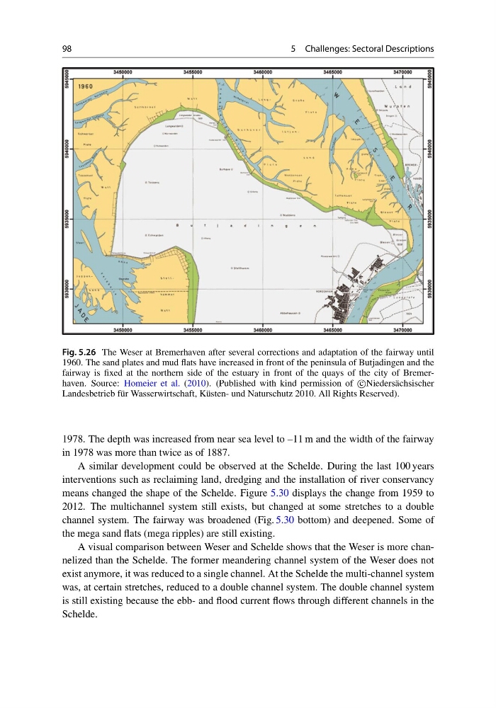
Fig. 5.26 The Weser at Bremerhaven after several corrections and adaptation of the fairway until
1960. The sand plates and mud flats have increased in front of the peninsula of Butjadingen and the
fairway is fixed at the northern side of the estuary in front of the quays of the city of Bremerhaven. Source: Homeier et al. (2010). (Published with kind permission of c
Niedersächsischer
Landesbetrieb für Wasserwirtschaft, Küsten- und Naturschutz 2010. All Rights Reserved).
1978. The depth was increased from near sea level to –11 m and the width of the fairway
in 1978 was more than twice as of 1887.
A similar development could be observed at the Schelde. During the last 100 years
interventions such as reclaiming land, dredging and the installation of river conservancy
means changed the shape of the Schelde. Figure 5.30 displays the change from 1959 to
2012. The multichannel system still exists, but changed at some stretches to a double
channel system. The fairway was broadened (Fig. 5.30 bottom) and deepened. Some of
the mega sand flats (mega ripples) are still existing.
A visual comparison between Weser and Schelde shows that the Weser is more channelized than the Schelde. The former meandering channel system of the Weser does not
exist anymore, it was reduced to a single channel. At the Schelde the multi-channel system
was, at certain stretches, reduced to a double channel system. The double channel system
is still existing because the ebb- and flood current flows through different channels in the
Schelde.
5 Challenges: Sectoral Descriptions
Fig. 5.26 The Weser at Bremerhaven after several corrections and adaptation of the fairway until
1960. The sand plates and mud flats have increased in front of the peninsula of Butjadingen and the
fairway is fixed at the northern side of the estuary in front of the quays of the city of Bremerhaven. Source: Homeier et al. (2010). (Published with kind permission of c
Niedersächsischer
Landesbetrieb für Wasserwirtschaft, Küsten- und Naturschutz 2010. All Rights Reserved).
1978. The depth was increased from near sea level to –11 m and the width of the fairway
in 1978 was more than twice as of 1887.
A similar development could be observed at the Schelde. During the last 100 years
interventions such as reclaiming land, dredging and the installation of river conservancy
means changed the shape of the Schelde. Figure 5.30 displays the change from 1959 to
2012. The multichannel system still exists, but changed at some stretches to a double
channel system. The fairway was broadened (Fig. 5.30 bottom) and deepened. Some of
the mega sand flats (mega ripples) are still existing.
A visual comparison between Weser and Schelde shows that the Weser is more channelized than the Schelde. The former meandering channel system of the Weser does not
exist anymore, it was reduced to a single channel. At the Schelde the multi-channel system
was, at certain stretches, reduced to a double channel system. The double channel system
is still existing because the ebb- and flood current flows through different channels in the
Schelde.