

4 Integration of Remotely Sensed Data into Geographical Information Systems
69
256 classes because classification algorithms operate with a cost proportional to n 2
where n are the number of classes. Second, GIS class labels may not correspond to
detectable remote sensing classes, which would need remotely sensed data of finer
resolution and incorporation of contextual knowledge into a classification algorithm. Conversely, some classes easily identified by remote sensing may not correspond to classes desired by a hydrologist, which may have to be grouped into
similar and fewer classes.
Ehlers et al. (1989) discuss strategies for efficient integration of Remotely
Sensed Data Processing System (RSDPS) with a GIS, and classify these strategies
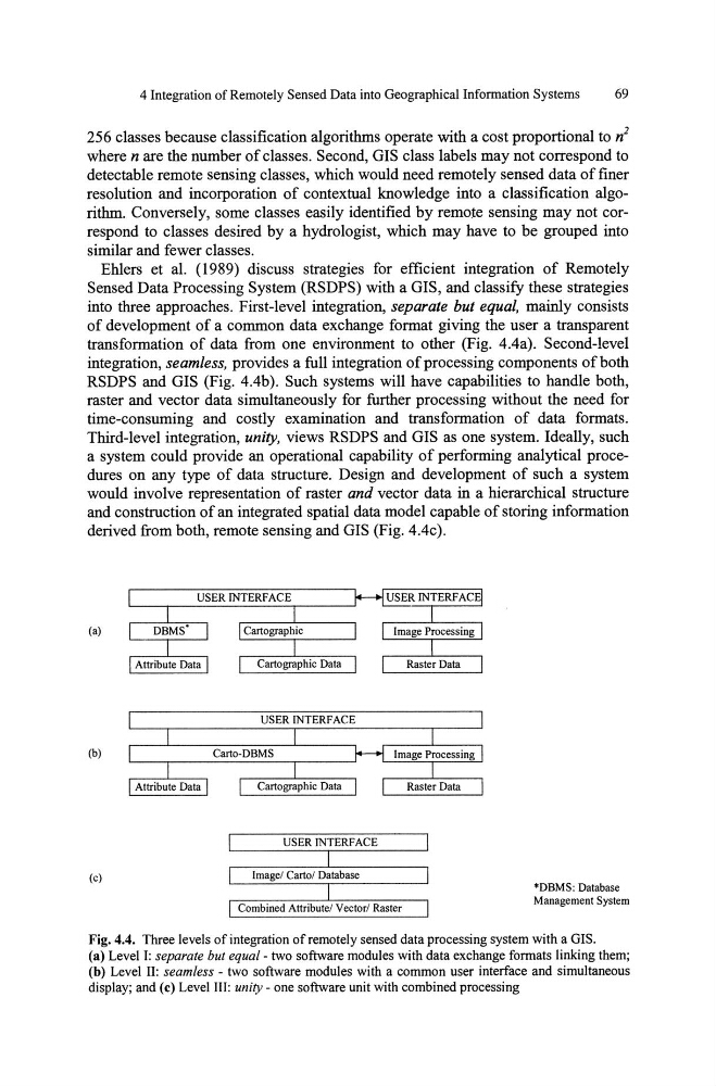
into three approaches. First-level integration, separate but equal, mainly consists
of development of a common data exchange format giving the user a transparent
transformation of data from one environment to other (Fig. 4.4a). Second-level
integration, seamless, provides a full integration of processing components of both
RSDPS and GIS (Fig. 4.4b). Such systems will have capabilities to handle both,
raster and vector data simultaneously for further processing without the need for
time-consuming and costly examination and transformation of data formats.
Third-level integration, unity, views RSDPS and GIS as one system. Ideally, such
a system could provide an operational capability of performing analytical procedures on any type of data structure. Design and development of such a system
would involve representation of raster and vector data in a hierarchical structure
and construction of an integrated spatial data model capable of storing information
derived from both, remote sensing and GIS (Fig. 4.4c).
(a)
(b)
(c)
USER INTERFACE
Image! Carta! Database
Combined Attribute! Vector! Raster
*DBMS; Database
Management System
Fig. 4.4. Three levels of integration of remotely sensed data processing system with a GIS.
(a) Level I: separate but equal- two software modules with data exchange formats linking them;
(b) Level II: seamless - two software modules with a common user interface and simultaneous
display; and (c) Level III: unity - one software unit with combined processing
69
256 classes because classification algorithms operate with a cost proportional to n 2
where n are the number of classes. Second, GIS class labels may not correspond to
detectable remote sensing classes, which would need remotely sensed data of finer
resolution and incorporation of contextual knowledge into a classification algorithm. Conversely, some classes easily identified by remote sensing may not correspond to classes desired by a hydrologist, which may have to be grouped into
similar and fewer classes.
Ehlers et al. (1989) discuss strategies for efficient integration of Remotely
Sensed Data Processing System (RSDPS) with a GIS, and classify these strategies
into three approaches. First-level integration, separate but equal, mainly consists
of development of a common data exchange format giving the user a transparent
transformation of data from one environment to other (Fig. 4.4a). Second-level
integration, seamless, provides a full integration of processing components of both
RSDPS and GIS (Fig. 4.4b). Such systems will have capabilities to handle both,
raster and vector data simultaneously for further processing without the need for
time-consuming and costly examination and transformation of data formats.
Third-level integration, unity, views RSDPS and GIS as one system. Ideally, such
a system could provide an operational capability of performing analytical procedures on any type of data structure. Design and development of such a system
would involve representation of raster and vector data in a hierarchical structure
and construction of an integrated spatial data model capable of storing information
derived from both, remote sensing and GIS (Fig. 4.4c).
(a)
(b)
(c)
USER INTERFACE
Image! Carta! Database
Combined Attribute! Vector! Raster
*DBMS; Database
Management System
Fig. 4.4. Three levels of integration of remotely sensed data processing system with a GIS.
(a) Level I: separate but equal- two software modules with data exchange formats linking them;
(b) Level II: seamless - two software modules with a common user interface and simultaneous
display; and (c) Level III: unity - one software unit with combined processing