

4 Integration of Remotely Sensed Data into Geographical Information Systems
67
Verification
Aeri.1
Photographs
lntermediate Files
Existing Data
(Maps, Repons)
Relations
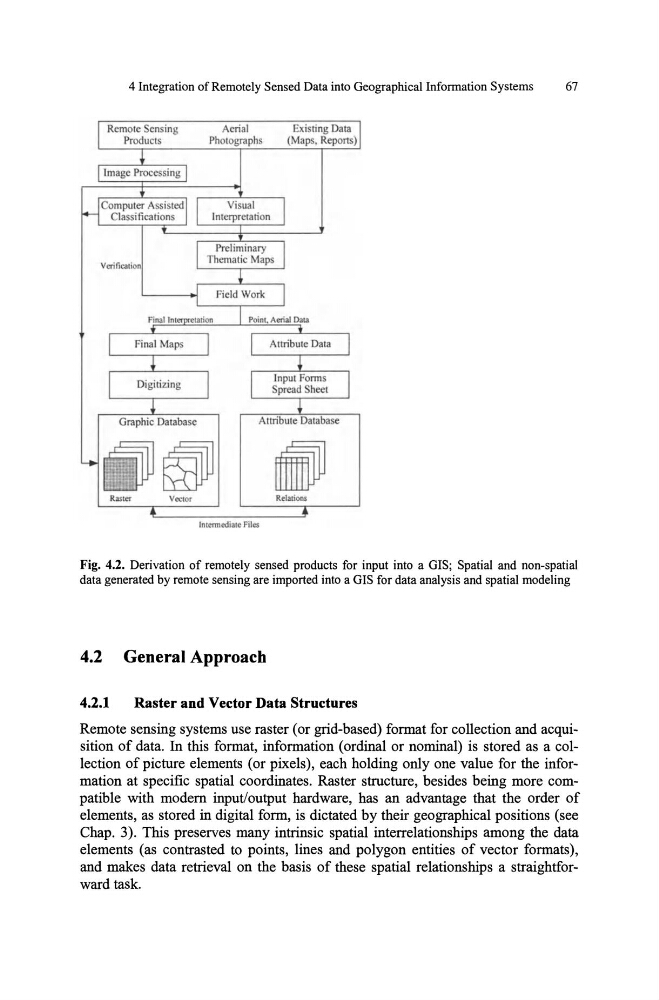
Fig. 4.2. Derivation of remotely sensed products for input into a GIS; Spatial and non-spatial
data generated by remote sensing are imported into a GIS for data analysis and spatial modeling
4.2 General Approach
4.2.1
Raster and Vector Data Structures
Remote sensing systems use raster (or grid-based) format for collection and acquisition of data. In this format, information (ordinal or nominal) is stored as a collection of picture elements (or pixels), each holding only one value for the information at specific spatial coordinates. Raster structure, besides being more compatible with modem input/output hardware, has an advantage that the order of
elements, as stored in digital form, is dictated by their geographical positions (see
Chap. 3). This preserves many intrinsic spatial interrelationships among the data
elements (as contrasted to points, lines and polygon entities of vector formats),
and makes data retrieval on the basis of these spatial relationships a straightforward task.
67
Verification
Aeri.1
Photographs
lntermediate Files
Existing Data
(Maps, Repons)
Relations
Fig. 4.2. Derivation of remotely sensed products for input into a GIS; Spatial and non-spatial
data generated by remote sensing are imported into a GIS for data analysis and spatial modeling
4.2 General Approach
4.2.1
Raster and Vector Data Structures
Remote sensing systems use raster (or grid-based) format for collection and acquisition of data. In this format, information (ordinal or nominal) is stored as a collection of picture elements (or pixels), each holding only one value for the information at specific spatial coordinates. Raster structure, besides being more compatible with modem input/output hardware, has an advantage that the order of
elements, as stored in digital form, is dictated by their geographical positions (see
Chap. 3). This preserves many intrinsic spatial interrelationships among the data
elements (as contrasted to points, lines and polygon entities of vector formats),
and makes data retrieval on the basis of these spatial relationships a straightforward task.