

66
N.M. Mattikalli and E.T. Engman
Input
Digitization
Geo-coding
Image
~
Processing
Entity
Transformation
& Formatting
Storage
Raw Data
~
Topology
Database
Managemen
Chronology
- ' c~~
In
•
Retrieval
& Analysis
Retrieval
Statistical
Analysis
Spatial
Modeling
• ~ Ai""
Geographic Database
Output
Report
Generation
Mapping
H
Graphic
Display
Data Export
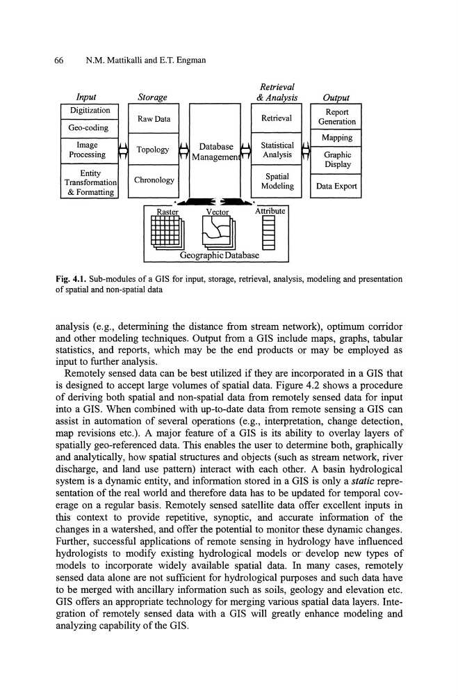
Fig. 4.1. Sub-modules of a GIS for input, storage, retrieval, analysis, modeling and presentation
of spatial and non-spatial data
analysis (e.g., detennining the distance from stream network), optimum corridor
and other modeling techniques. Output from a GIS include maps, graphs, tabular
statistics, and reports, which may be the end products or may be employed as
input to further analysis.
Remotely sensed data can be best utilized if they are incorporated in a GIS that
is designed to accept large volumes of spatial data. Figure 4.2 shows a procedure
of deriving both spatial and non-spatial data from remotely sensed data for input
into a GIS. When combined with up-to-date data from remote sensing a GIS can
assist in automation of several operations (e.g., interpretation, change detection,
map revisions etc.). A major feature of a GIS is its ability to overlay layers of
spatially geo-referenced data. This enables the user to determine both, graphically
and analytically, how spatial structures and objects (such as stream network, river
discharge, and land use pattern) interact with each other. A basin hydrological
system is a dynamic entity, and infonnation stored in a GIS is only a static representation of the real world and therefore data has to be updated for temporal coverage on a regular basis. Remotely sensed satellite data offer excellent inputs in
this context to provide repetitive, synoptic, and accurate infonnation of the
changes in a watershed, and offer the potential to monitor these dynamic changes.
Further, successful applications of remote sensing in hydrology have influenced
hydrologists to modify existing hydrological models or develop new types of
models to incorporate widely available spatial data. In many cases, remotely
sensed data alone are not sufficient for hydrological purposes and such data have
to be merged with ancillary infonnation such as soils, geology and elevation etc.
GIS offers an appropriate technology for merging various spatial data layers. Integration of remotely sensed data with a GIS will greatly enhance modeling and
analyzing capability of the GIS.
N.M. Mattikalli and E.T. Engman
Input
Digitization
Geo-coding
Image
~
Processing
Entity
Transformation
& Formatting
Storage
Raw Data
~
Topology
Database
Managemen
Chronology
- ' c~~
In
•
Retrieval
& Analysis
Retrieval
Statistical
Analysis
Spatial
Modeling
• ~ Ai""
Geographic Database
Output
Report
Generation
Mapping
H
Graphic
Display
Data Export
Fig. 4.1. Sub-modules of a GIS for input, storage, retrieval, analysis, modeling and presentation
of spatial and non-spatial data
analysis (e.g., detennining the distance from stream network), optimum corridor
and other modeling techniques. Output from a GIS include maps, graphs, tabular
statistics, and reports, which may be the end products or may be employed as
input to further analysis.
Remotely sensed data can be best utilized if they are incorporated in a GIS that
is designed to accept large volumes of spatial data. Figure 4.2 shows a procedure
of deriving both spatial and non-spatial data from remotely sensed data for input
into a GIS. When combined with up-to-date data from remote sensing a GIS can
assist in automation of several operations (e.g., interpretation, change detection,
map revisions etc.). A major feature of a GIS is its ability to overlay layers of
spatially geo-referenced data. This enables the user to determine both, graphically
and analytically, how spatial structures and objects (such as stream network, river
discharge, and land use pattern) interact with each other. A basin hydrological
system is a dynamic entity, and infonnation stored in a GIS is only a static representation of the real world and therefore data has to be updated for temporal coverage on a regular basis. Remotely sensed satellite data offer excellent inputs in
this context to provide repetitive, synoptic, and accurate infonnation of the
changes in a watershed, and offer the potential to monitor these dynamic changes.
Further, successful applications of remote sensing in hydrology have influenced
hydrologists to modify existing hydrological models or develop new types of
models to incorporate widely available spatial data. In many cases, remotely
sensed data alone are not sufficient for hydrological purposes and such data have
to be merged with ancillary infonnation such as soils, geology and elevation etc.
GIS offers an appropriate technology for merging various spatial data layers. Integration of remotely sensed data with a GIS will greatly enhance modeling and
analyzing capability of the GIS.