

34
H. Rott
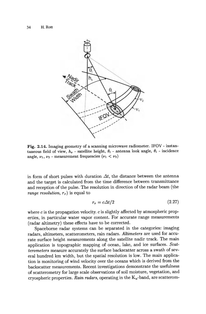
Fig. 2.14. Imaging geometry of a scanning microwave radiometer. IFOV - instantaneous field of view, hs - satellite height, Oz - antenna look angle, Oi - incidence
angle, Ill, 112 - measurement frequencies (Ill < 112)
in form of short pulses with duration .1t, the distance between the antenna
and the target is calculated from the time difference between transmittance
and reception of the pulse. The resolution in direction of the radar beam (the
range resolution, r r) is equal to
rr = c.1t/2
(2.27)
where c is the propagation velocity. c is slightly affected by atmospheric properties, in particular water vapor content. For accurate range measurements
(radar altimetry) these effects have to be corrected.
Space borne radar systems can be separated in the categories: imaging
radars, altimeters, scatterometers, rain radars. Altimeters are used for accurate surface height measurements along the satellite nadir track. The main
application is topographic mapping of ocean, lake, and ice surfaces. Scatterometers measure accurately the surface backscatter across a swath of sever,al hundred km width, but the spatial resolution is low. The main application is monitoring of wind velocity over the oceans which is derived from the
backscatter measurements. Recent investigations demonstrate the usefulness
of scatterometry for large scale observations of soil moisture, vegetation, and
cryospheric properties. Rain radars, operating in the Ku-band, are scatterom-
H. Rott
Fig. 2.14. Imaging geometry of a scanning microwave radiometer. IFOV - instantaneous field of view, hs - satellite height, Oz - antenna look angle, Oi - incidence
angle, Ill, 112 - measurement frequencies (Ill < 112)
in form of short pulses with duration .1t, the distance between the antenna
and the target is calculated from the time difference between transmittance
and reception of the pulse. The resolution in direction of the radar beam (the
range resolution, r r) is equal to
rr = c.1t/2
(2.27)
where c is the propagation velocity. c is slightly affected by atmospheric properties, in particular water vapor content. For accurate range measurements
(radar altimetry) these effects have to be corrected.
Space borne radar systems can be separated in the categories: imaging
radars, altimeters, scatterometers, rain radars. Altimeters are used for accurate surface height measurements along the satellite nadir track. The main
application is topographic mapping of ocean, lake, and ice surfaces. Scatterometers measure accurately the surface backscatter across a swath of sever,al hundred km width, but the spatial resolution is low. The main application is monitoring of wind velocity over the oceans which is derived from the
backscatter measurements. Recent investigations demonstrate the usefulness
of scatterometry for large scale observations of soil moisture, vegetation, and
cryospheric properties. Rain radars, operating in the Ku-band, are scatterom-