

452
E.T. Engman and G.A. Schultz
20.5 Intensive Field Campaigns
In many ways the conduct of several of the existing and planned intensive field
campaigns may provide the best combinations of remote sensing and traditional
hydrologic data for model development and validation. The intensive field campaigns provide an opportunity to plan and carry out a data collection program that
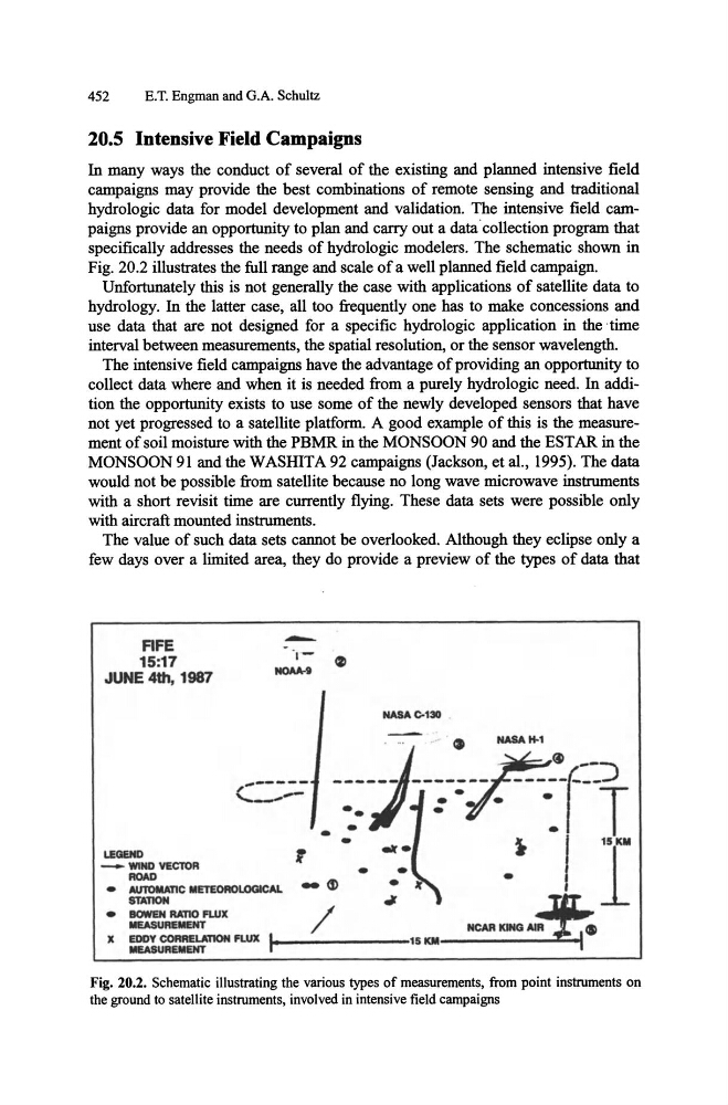
specifically addresses the needs of hydrologic modelers. The schematic shown in
Fig. 20.2 illustrates the full range and scale of a well planned field campaign.
Unfortunately this is not generally the case with applications of satellite data to
hydrology. In the latter case, all too frequently one has to make concessions and
use data that are not designed for a specific hydrologic application in the -time
interval between measurements, the spatial resolution, or the sensor wavelength.
The intensive field campaigns have the advantage of providing an opportunity to
collect data where and when it is needed from a purely hydrologic need. In addition the opportunity exists to use some of the newly developed sensors that have
not yet progressed to a satellite platform. A good example of this is the measurement of soil moisture with the PBMR in the MONSOON 90 and the EST AR in the
MONSOON 91 and the WASHITA 92 campaigns (Jackson, et al., 1995). The data
would not be possible from satellite because no long wave microwave instruments
with a short revisit time are currently flying. These data sets were possible only
with aircraft mounted instruments.
The value of such data sets cannot be overlooked. Although they eclipse only a
few days over a limited area, they do provide a preview of the types of data that
FIFE
15:17
JUNE 4th, 1987
LEGEND
_
WIND YEClOA
ROAD
•
AUTOMAnC METEOROLOGICAL
STAllON
•
IIOWEH RAno FWX
MEASUREMENT
-
NASAC-130 .
•
,
• •
- 6 )
/
X EDDY CORAEUmON FLUX
MEASUREMENT
.... _ _ _ _ _ _ _ 15 KM------~-I
Fig. 20.2. Schematic illustrating the various types of measurements, from point instruments on
the ground to satellite instruments, involved in intensive field campaigns
E.T. Engman and G.A. Schultz
20.5 Intensive Field Campaigns
In many ways the conduct of several of the existing and planned intensive field
campaigns may provide the best combinations of remote sensing and traditional
hydrologic data for model development and validation. The intensive field campaigns provide an opportunity to plan and carry out a data collection program that
specifically addresses the needs of hydrologic modelers. The schematic shown in
Fig. 20.2 illustrates the full range and scale of a well planned field campaign.
Unfortunately this is not generally the case with applications of satellite data to
hydrology. In the latter case, all too frequently one has to make concessions and
use data that are not designed for a specific hydrologic application in the -time
interval between measurements, the spatial resolution, or the sensor wavelength.
The intensive field campaigns have the advantage of providing an opportunity to
collect data where and when it is needed from a purely hydrologic need. In addition the opportunity exists to use some of the newly developed sensors that have
not yet progressed to a satellite platform. A good example of this is the measurement of soil moisture with the PBMR in the MONSOON 90 and the EST AR in the
MONSOON 91 and the WASHITA 92 campaigns (Jackson, et al., 1995). The data
would not be possible from satellite because no long wave microwave instruments
with a short revisit time are currently flying. These data sets were possible only
with aircraft mounted instruments.
The value of such data sets cannot be overlooked. Although they eclipse only a
few days over a limited area, they do provide a preview of the types of data that
FIFE
15:17
JUNE 4th, 1987
LEGEND
_
WIND YEClOA
ROAD
•
AUTOMAnC METEOROLOGICAL
STAllON
•
IIOWEH RAno FWX
MEASUREMENT
-
NASAC-130 .
•
,
• •
- 6 )
/
X EDDY CORAEUmON FLUX
MEASUREMENT
.... _ _ _ _ _ _ _ 15 KM------~-I
Fig. 20.2. Schematic illustrating the various types of measurements, from point instruments on
the ground to satellite instruments, involved in intensive field campaigns